Trail Walking Unknown - ACTIVE LOG083432 - Photo
 Alizée.pee
Alizée.pee

User GUIDE

© OpenStreetMap contributors
Length
Length
22 km
Max alt
Max alt
1281 m
Uphill gradient
Uphill gradient
1083 m
Km-Effort
Km-Effort  
36 km
Min alt
Min alt
553 m
Downhill gradient
Downhill gradient
1085 m
Boucle
Boucle
Yes
Creation date :
2019-09-04 12:08:08.684
Updated on :
2019-09-04 12:09:32.61

(1 Reviews)

Walking
Walking
7h23
Difficulty : Difficult

Scan this QR Code to open this trail in the SityTrail application

FREE GPS app for hiking

Logo SityTrail SityTrail

IGN / Geographical institutes

Download SityTrail from the App Store Download SityTrail from Google Play

Logo SityTrail SityTrail World

The world is yours!

Download SityTrail from the App Store Download SityTrail from Google Play Download SityTrail on Huawei AppGallery

About

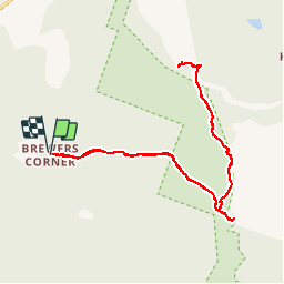
Trail Walking of 22 km to be discovered at Vermont, Rutland County, Unknown. This trail is proposed by Alizée.pee.

Description

Le mont Killington est la deuxième montagne la plus haute eu Vermont. Elle offre un panorama et une très belle vue sur presque 360 degrés. Cette randonnée passe par le sentier « Bucklin Trail » qui vous fera passer par le sommet du Mont Killington ainsi que le Pico Peak. Le début du sentier est assez plat et rapide, jusqu’au moment où l’ascension commence. La montée pour arriver au sommet du Mont Killington  est assez abrupte et vous demandera a plusieurs reprises d’utiliser vos mains afin de franchir le sentier rocheux, qui est assez court mais pas des plus évident. Arrivé au sommet du mont Killington, votre randonnée continue pour rejoindre le Pico Peak. Finalement, une fois celui-ci atteint, il vous faudra reprendre le sentier en sens inverse pour rejoindre le départ de la randonnée.

Elevation profile

Points of interest

Point of interest Unknown - Stationnement - Photo
Alizée.pee
UNKNOWN 
Point of interest Unknown - Sommet - Pico Peak - Photo
Alizée.pee
Point of interest Unknown - Sommet - Killington - Photo
Alizée.pee
Point of interest Unknown - Pico Camp - Photo
Alizée.pee
UNKNOWN 
Point of interest Unknown - Intersection 2 - Photo
Alizée.pee
Point of interest Unknown - Intersection 1 - Photo
Alizée.pee
Point of interest Unknown - Cooper Lodge - Photo
Alizée.pee
UNKNOWN 

Positioning

Country:
United States
Region :
Vermont
Department/Province :
Rutland County
Municipality :
Unknown
Location:
Mendon
Start:(UTM)
671333 ; 4831809 (18T) N.

Comments

Please log in to post a review or rate the element


Merci pour ce partage !


Trails nearby

Trail Walking Unknown - 2015-01-04 12:26:37 - Photo
Walking
GUIDE
Alizée.pee

Walking

Difficult
(1)
Unknown, Vermont, Rutland County, United States
11.5 km | 21 km-effort
4h 16min
Yes


Close
My subscriptions