Trail Walking Unknown - 18-JAN-13 - Photo
 Alizée.pee
Alizée.pee

User GUIDE

© OpenStreetMap contributors
Length
Length
12.4 km
Max alt
Max alt
1329 m
Uphill gradient
Uphill gradient
916 m
Km-Effort
Km-Effort  
25 km
Min alt
Min alt
412 m
Downhill gradient
Downhill gradient
914 m
Boucle
Boucle
Yes
Creation date :
2019-09-04 11:36:14.464
Updated on :
2019-09-04 11:37:44.963

(1 Reviews)

Walking
Walking
4h53
Difficulty : Medium

Scan this QR Code to open this trail in the SityTrail application

FREE GPS app for hiking

Logo SityTrail SityTrail

IGN / Geographical institutes

Download SityTrail from the App Store Download SityTrail from Google Play

Logo SityTrail SityTrail World

The world is yours!

Download SityTrail from the App Store Download SityTrail from Google Play Download SityTrail on Huawei AppGallery

About

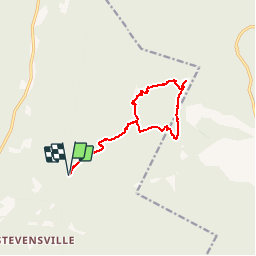
Trail Walking of 12.4 km to be discovered at Vermont, Chittenden County, Unknown. This trail is proposed by Alizée.pee.

Description

Le mont Mansfield est la plus haute montagne du Vermont. Elle possède de nombreux sommets qui ressemblent à la tête d’un homme. Les six sommets qui la composent possèdent donc tous des noms représentant une partie de la tête (chin, nose, upper lip, …). Cette randonnée, de niveau de difficulté moyen, monte jusqu’au sommet « Chin ». Le sentier emprunter se nomme le « Sunset Ridge Trail » qui est l’un des plus beaux sentiers qu’offre cette montagne. Du sommet, vous pourrez admirer un des plus beaux panoramas de tout le Vermont.

Elevation profile

Points of interest

Point of interest Unknown - Sunset Ridge Trail - Photo
Alizée.pee
Point of interest Unknown - Stationnement d'été - Photo
Alizée.pee
Point of interest Unknown - Stationnement d'hiver - Photo
Alizée.pee
Point of interest Unknown - Sommet - Mansfield - Photo
Alizée.pee
Point of interest Unknown - Intersection 3 - Photo
Alizée.pee
Point of interest Unknown - Intersection 2 - Photo
Alizée.pee
Point of interest Unknown - Intersection 1 - Photo
Alizée.pee
Point of interest Unknown - Halfway House Trail - Photo
Alizée.pee

Positioning

Country:
United States
Region :
Vermont
Department/Province :
Chittenden County
Municipality :
Unknown
Location:
Underhill
Start:(UTM)
670510 ; 4931982 (18T) N.

Comments

Please log in to post a review or rate the element


Merci pour ce partage !


Trails nearby

Trail Walking Unknown - 07-JUL-12 - Photo
Walking
GUIDE
Alizée.pee

Walking

Difficult
(1)
Unknown, Vermont, Lamoille County, United States
7.8 km | 18.9 km-effort
3h 39min
Yes
Trail Walking Unknown - Vermont  - Photo
Walking
jib971

Walking

Medium
Unknown, Vermont, Lamoille County, United States
5.1 km | 9.7 km-effort
3h 23min
Yes


Close
My subscriptions