![](/images/other/stat-length.png)
![Trail On foot Nantes - Parcours de l'Erdre - Photo](https://media.geolcdn.com/t/1900/400/ext.pjpeg?maxdim=2&url=https%3A%2F%2Fstatic1.geolcdn.com%2Fsiteimages%2Fupload%2Ffiles%2F1545311037marcheuse_200dpi.jpg)
Parcours de l'Erdre
popajoel
User
![Length](/images/other/stat-length.png)
Length
46 km
![Max alt](https://static1.geolcdn.com/siteimages/upload/files/1508320355ic_sort_altitude_max_24dp.png)
Max alt
33 m
![Uphill gradient](https://static1.geolcdn.com/siteimages/upload/files/1508320355ic_sort_den_pos_24dp.png)
Uphill gradient
485 m
![Km-Effort](/images/other/stat-length.png)
Km-Effort
52 km
![Min alt](https://static1.geolcdn.com/siteimages/upload/files/1508320355ic_sort_altitude_min_24dp.png)
Min alt
2 m
![Downhill gradient](https://static1.geolcdn.com/siteimages/upload/files/1508320355ic_sort_den_neg_24dp.png)
Downhill gradient
486 m
![Boucle](https://static1.geolcdn.com/siteimages/upload/files/16400158638029165_repeat_loop_refresh_sync_direction_icon.png)
Boucle
Yes
Creation date :
2019-09-03 17:11:58.779
Updated on :
2019-09-03 17:15:05.572
![On foot](https://static1.geolcdn.com/sitytour/trail-icons/100.png)
--
Difficulty : Very easy
![Cycle](https://static1.geolcdn.com/sitytour/trail-icons/200.png)
--
Difficulty : Very easy
![Scan this QR Code to open this trail in the SityTrail application](https://capi.geolives.com/qq0zvz2zws4bq2lad0pu/sitytour/trails/2190882/qr.png?size=200)
FREE GPS app for hiking
About
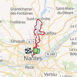
Trail On foot of 46 km to be discovered at Pays de la Loire, Loire-Atlantique, Nantes. This trail is proposed by popajoel.
Description
Initialement prévu pour les rendez vous de l'Erdre, concerts Jazz et Blues sur le parcours fin Aout.
A faire a pied pour les plus courageux ou à vélo.
Rendez vous annuel.
Points of interest
Positioning
Country:
France
Region :
Pays de la Loire
Department/Province :
Loire-Atlantique
Municipality :
Nantes
Location:
Unknown
Start:(Dec)
Start:(UTM)
609432 ; 5230655 (30T) N.
Comments
Trails nearby
![Trail Walking Nantes - Bords de Sevre nantaise - Photo](https://media.geolcdn.com/t/375/260/ext.jpg?maxdim=2&url=https%3A%2F%2Fstatic1.geolcdn.com%2Fsiteimages%2Fupload%2Ffiles%2F1553511878bg_sport_marche.png)
![Walking Walking](https://static1.geolcdn.com/sitytour/trail-icons/101.png)
Bords de Sevre nantaise
Walking
Very easy
(1)
Nantes,
Pays de la Loire,
Loire-Atlantique,
France
![](/images/other/stat-length.png)
13.7 km | 14.8 km-effort
2h 41min
![](https://static1.geolcdn.com/siteimages/upload/files/16400158638029165_repeat_loop_refresh_sync_direction_icon.png)
Yes
![Trail Walking Rezé - Rezé - nord - Photo](https://media.geolcdn.com/t/375/260/ext.jpg?maxdim=2&url=https%3A%2F%2Fstatic1.geolcdn.com%2Fsiteimages%2Fupload%2Ffiles%2F1553511878bg_sport_marche.png)
![Walking Walking](https://static1.geolcdn.com/sitytour/trail-icons/101.png)
Rezé - nord
Walking
Easy
(1)
Rezé,
Pays de la Loire,
Loire-Atlantique,
France
![](/images/other/stat-length.png)
9.5 km | 10.4 km-effort
2h 17min
![](https://static1.geolcdn.com/siteimages/upload/files/16400158638029165_repeat_loop_refresh_sync_direction_icon.png)
Yes
![Trail Walking Nantes - Nantes chezine-chantenay - Photo](https://media.geolcdn.com/t/375/260/ext.jpg?maxdim=2&url=https%3A%2F%2Fstatic1.geolcdn.com%2Fsiteimages%2Fupload%2Ffiles%2F1553511878bg_sport_marche.png)
![Walking Walking](https://static1.geolcdn.com/sitytour/trail-icons/101.png)
Nantes chezine-chantenay
Walking
Very easy
(1)
Nantes,
Pays de la Loire,
Loire-Atlantique,
France
![](/images/other/stat-length.png)
9.5 km | 11.1 km-effort
2h 26min
![](https://static1.geolcdn.com/siteimages/upload/files/16400158638029165_repeat_loop_refresh_sync_direction_icon.png)
Yes
![Trail Cycle Nantes - Nantes San Francisco à Mauves - Photo](https://media.geolcdn.com/t/375/260/ext.jpg?maxdim=2&url=https%3A%2F%2Fstatic1.geolcdn.com%2Fsiteimages%2Fupload%2Ffiles%2F1524743154velo.jpg)
![Cycle Cycle](https://static1.geolcdn.com/sitytour/trail-icons/200.png)
Nantes San Francisco à Mauves
Cycle
Easy
(2)
Nantes,
Pays de la Loire,
Loire-Atlantique,
France
![](/images/other/stat-length.png)
33 km | 36 km-effort
2h 6min
![](https://static1.geolcdn.com/siteimages/upload/files/16400158638029165_repeat_loop_refresh_sync_direction_icon.png)
Yes
![Trail Mountain bike Nantes - Nantes - Photo](https://media.geolcdn.com/t/375/260/ext.jpg?maxdim=2&url=https%3A%2F%2Fstatic1.geolcdn.com%2Fsiteimages%2Fupload%2Ffiles%2F1524743154velo.jpg)
![Mountain bike Mountain bike](https://static1.geolcdn.com/sitytour/trail-icons/202.png)
Nantes
Mountain bike
Medium
(1)
Nantes,
Pays de la Loire,
Loire-Atlantique,
France
![](/images/other/stat-length.png)
32 km | 38 km-effort
2h 6min
![](https://static1.geolcdn.com/siteimages/upload/files/16400158638029165_repeat_loop_refresh_sync_direction_icon.png)
Yes
![Trail Walking Bouguenais - Sèvre et Jaguère - Photo](https://media.geolcdn.com/t/375/260/ext.jpg?maxdim=2&url=https%3A%2F%2Fstatic1.geolcdn.com%2Fsiteimages%2Fupload%2Ffiles%2F1553511878bg_sport_marche.png)
![Walking Walking](https://static1.geolcdn.com/sitytour/trail-icons/101.png)
Sèvre et Jaguère
Walking
Very easy
(1)
Bouguenais,
Pays de la Loire,
Loire-Atlantique,
France
![](/images/other/stat-length.png)
13.3 km | 14.6 km-effort
Unknown
![](https://static1.geolcdn.com/siteimages/upload/files/16400158638029165_repeat_loop_refresh_sync_direction_icon.png)
Yes
![Trail Walking Saint-Sébastien-sur-Loire - Saint Sébastien-sur-Loire, départ stade René Massé - Photo](https://media.geolcdn.com/t/375/260/ext.jpg?maxdim=2&url=https%3A%2F%2Fstatic1.geolcdn.com%2Fsiteimages%2Fupload%2Ffiles%2F1553511878bg_sport_marche.png)
![Walking Walking](https://static1.geolcdn.com/sitytour/trail-icons/101.png)
Saint Sébastien-sur-Loire, départ stade René Massé
Walking
Easy
(1)
Saint-Sébastien-sur-Loire,
Pays de la Loire,
Loire-Atlantique,
France
![](/images/other/stat-length.png)
8.2 km | 9 km-effort
2h 23min
![](https://static1.geolcdn.com/siteimages/upload/files/16400158638029165_repeat_loop_refresh_sync_direction_icon.png)
Yes
![Trail Walking Saint-Sébastien-sur-Loire - Saint Sébastien-sur-Loire, départ stade René Massé - Photo](https://media.geolcdn.com/t/375/260/ext.jpg?maxdim=2&url=https%3A%2F%2Fstatic1.geolcdn.com%2Fsiteimages%2Fupload%2Ffiles%2F1553511878bg_sport_marche.png)
![Walking Walking](https://static1.geolcdn.com/sitytour/trail-icons/101.png)
Saint Sébastien-sur-Loire, départ stade René Massé
Walking
Easy
(1)
Saint-Sébastien-sur-Loire,
Pays de la Loire,
Loire-Atlantique,
France
![](/images/other/stat-length.png)
11.1 km | 12.3 km-effort
2h 23min
![](https://static1.geolcdn.com/siteimages/upload/files/16400158638029165_repeat_loop_refresh_sync_direction_icon.png)
Yes
![Trail On foot Rezé - Le Bord de la Loire - Photo](https://media.geolcdn.com/t/375/260/8c5a9e37-2f90-448b-89b3-97584c002767.jpeg&format=jpg&maxdim=2)
![On foot On foot](https://static1.geolcdn.com/sitytour/trail-icons/100.png)
Le Bord de la Loire
On foot
Easy
Rezé,
Pays de la Loire,
Loire-Atlantique,
France
![](/images/other/stat-length.png)
8 km | 8.6 km-effort
1h 57min
![](https://static1.geolcdn.com/siteimages/upload/files/16400158638029165_repeat_loop_refresh_sync_direction_icon.png)
Yes