Trail Walking Couffé - ballade de la Lhorie - Photo
 popajoel
popajoel

User

© OpenStreetMap contributors
Length
Length
6.2 km
Max alt
Max alt
63 m
Uphill gradient
Uphill gradient
95 m
Km-Effort
Km-Effort  
7.5 km
Min alt
Min alt
10 m
Downhill gradient
Downhill gradient
95 m
Boucle
Boucle
Yes
Creation date :
2019-09-03 17:03:31.467
Updated on :
2019-09-03 17:07:58.531

(0 Reviews)

Walking
Walking
1h37
Difficulty : Medium

Scan this QR Code to open this trail in the SityTrail application

FREE GPS app for hiking

Logo SityTrail SityTrail

IGN / Geographical institutes

Download SityTrail from the App Store Download SityTrail from Google Play

Logo SityTrail SityTrail World

The world is yours!

Download SityTrail from the App Store Download SityTrail from Google Play Download SityTrail on Huawei AppGallery

About

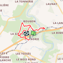
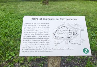
Trail Walking of 6.2 km to be discovered at Pays de la Loire, Loire-Atlantique, Couffé. This trail is proposed by popajoel.

Description

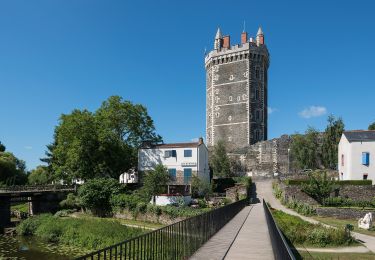
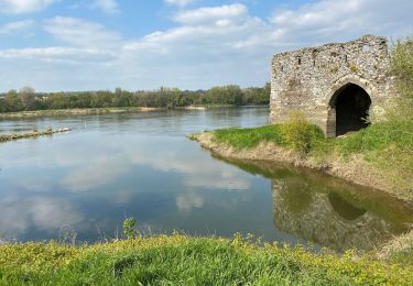
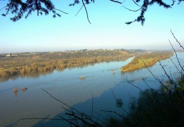
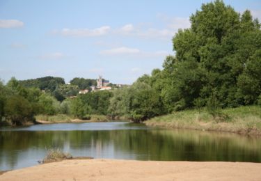
ballade très agréable a faire les jours de grande chaleur, accés très large avec passage sur passerelles au dessus de ruisseau et arrivée au "Havre"qui se deverse dans la loire au petit port d'Oudon.
possibilité de rallonger ce charmant parcours.

Elevation profile

Positioning

Country:
France
Region :
Pays de la Loire
Department/Province :
Loire-Atlantique
Municipality :
Couffé
Location:
Unknown
Start:(UTM)
628182 ; 5247255 (30T) N.

Trails nearby

Trail On foot Oudon - PR la vallée du Havre - Photo
On foot
GUIDE+

On foot

Easy
Oudon, Pays de la Loire, Loire-Atlantique, France
6 km | 6.9 km-effort
1h 33min
Yes
Trail Walking Orée-d'Anjou - Le prieuré Champtoceaux  - Photo
Walking
Poulpy77

Walking

Medium
Orée-d'Anjou, Pays de la Loire, Maine-et-Loire, France
6.3 km | 7.9 km-effort
2h 45min
Yes
Trail Walking Orée-d'Anjou - Parcours médiéval  - Champtoceaux - Photo
Walking
tracegps

Walking

Easy
Orée-d'Anjou, Pays de la Loire, Maine-et-Loire, France
3.3 km | 4.6 km-effort
1h 0min
Yes
Trail Walking Oudon - Les bords de Loire entre Oudon et Ancenis - Photo
Walking
tracegps

Walking

Medium
Oudon, Pays de la Loire, Loire-Atlantique, France
22 km | 24 km-effort
5h 0min
Yes
Trail Walking Orée-d'Anjou - Champtoceaux  - Photo
Walking
TonioNantes

Walking

Very easy
Orée-d'Anjou, Pays de la Loire, Maine-et-Loire, France
14.2 km | 17.4 km-effort
2h 36min
Yes
Trail Walking Orée-d'Anjou - CHAMPTOCEAUX Parmi les vignes - Photo
Walking
Poulpy77

Walking

Easy
(1)
Orée-d'Anjou, Pays de la Loire, Maine-et-Loire, France
4.8 km | 6 km-effort
1h 2min
Yes
Trail Walking Orée-d'Anjou - Sentier contes et légendes - Champtoceaux  - Photo
Walking
tracegps

Walking

Medium
(1)
Orée-d'Anjou, Pays de la Loire, Maine-et-Loire, France
3 km | 4 km-effort
1h 0min
Yes
Trail Mountain bike Oudon - Oudon - Launay - Mauves - Photo
Mountain bike
tracegps

Mountain bike

Medium
(1)
Oudon, Pays de la Loire, Loire-Atlantique, France
34 km | 39 km-effort
2h 0min
Yes
Trail Walking Oudon - Oudon - Launay - Mauves - Photo
Walking
tracegps

Walking

Difficult
Oudon, Pays de la Loire, Loire-Atlantique, France
34 km | 39 km-effort
7h 0min
Yes


Close
My subscriptions