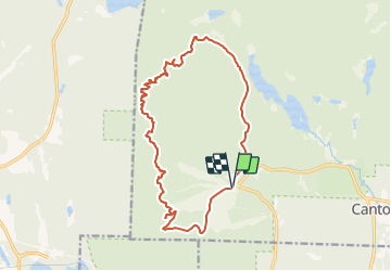
![](/images/other/stat-length.png)
![Trail Walking Orford - 14-JUL-13 - Photo](https://media.geolcdn.com/t/1900/400/ext.pjpeg?maxdim=2&url=https%3A%2F%2Fstatic1.geolcdn.com%2Fsiteimages%2Fupload%2Ffiles%2F1553511878bg_sport_marche.png)
14-JUL-13
Alizée.pee
User GUIDE
![Length](/images/other/stat-length.png)
![Max alt](https://static1.geolcdn.com/siteimages/upload/files/1508320355ic_sort_altitude_max_24dp.png)
![Uphill gradient](https://static1.geolcdn.com/siteimages/upload/files/1508320355ic_sort_den_pos_24dp.png)
![Km-Effort](/images/other/stat-length.png)
![Min alt](https://static1.geolcdn.com/siteimages/upload/files/1508320355ic_sort_altitude_min_24dp.png)
![Downhill gradient](https://static1.geolcdn.com/siteimages/upload/files/1508320355ic_sort_den_neg_24dp.png)
![Boucle](https://static1.geolcdn.com/siteimages/upload/files/16400158638029165_repeat_loop_refresh_sync_direction_icon.png)
![Walking](https://static1.geolcdn.com/sitytour/trail-icons/101.png)
6h00
Difficulty : Very difficult
![Scan this QR Code to open this trail in the SityTrail application](https://capi.geolives.com/qq0zvz2zws4bq2lad0pu/sitytour/trails/2190485/qr.png?size=200)
FREE GPS app for hiking
About
Trail Walking of 17 km to be discovered at Quebec, Memphrémagog, Orford. This trail is proposed by Alizée.pee.
Description
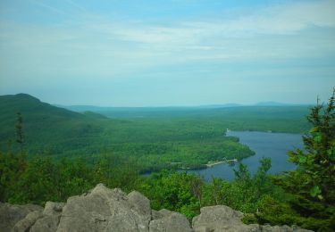
Cette randonnée se situe dans le Parc National du Mont-Orford. Ce sentier est l’un de ceux qui offre les plus belles vues de la grande région de Montréal. Le sentier commence par suivre une piste cyclable jusqu’au moment où ça commence à être un peu plus abrupte. L’ascension débute avec un sentier bien balisé et facile à suivre avec plusieurs possibilités de points de vue (sur le Mont Chauve notamment). Ensuite, le sentier se poursuit jusqu’au Pic de la Roche Fendue qui offre une vue splendide sur le Lac Stukely. Finalement, la montée finale vous amène jusqu’au sommet rocheux du Pic de l’Ours. Attention, vos mollets risquent de chauffer un peu. Cette randonnée comporte deux alternatives pour le retour : Soit vous suivez le sentier en sens inverse pour retrouver le point de départ, ou vous faites une boucle jusqu’au Mont Orford qui vous offre de magnifiques panoramas. Voici la randonnée jusqu’au Mont Orford.
Points of interest
Positioning
Comments
Trails nearby
![On foot On foot](https://static1.geolcdn.com/sitytour/trail-icons/100.png)
On foot
![](/images/other/stat-length.png)
![](https://static1.geolcdn.com/siteimages/upload/files/16400158638029165_repeat_loop_refresh_sync_direction_icon.png)
![Trail Walking Orford - Z - Photo](https://media.geolcdn.com/t/375/260/ext.jpg?maxdim=2&url=https%3A%2F%2Fstatic1.geolcdn.com%2Fsiteimages%2Fupload%2Ffiles%2F1553511878bg_sport_marche.png)
![Walking Walking](https://static1.geolcdn.com/sitytour/trail-icons/101.png)
![Trail Trail Orford - avec zac - Photo](https://media.geolcdn.com/t/375/260/ext.jpg?maxdim=2&url=https%3A%2F%2Fstatic1.geolcdn.com%2Fsiteimages%2Fupload%2Ffiles%2F1524743154running.jpg)
![Trail Trail](https://static1.geolcdn.com/sitytour/trail-icons/104.png)
![Trail Walking Orford - mont orford - Photo](https://media.geolcdn.com/t/375/260/ext.jpg?maxdim=2&url=https%3A%2F%2Fstatic1.geolcdn.com%2Fsiteimages%2Fupload%2Ffiles%2F1553511878bg_sport_marche.png)
![Walking Walking](https://static1.geolcdn.com/sitytour/trail-icons/101.png)