Trail Walking Notre-Dame-des-Bois - 2014-07-06 16:25:48 - Photo
 Alizée.pee
Alizée.pee

User GUIDE

© OpenStreetMap contributors
Length
Length
16.5 km
Max alt
Max alt
1107 m
Uphill gradient
Uphill gradient
786 m
Km-Effort
Km-Effort  
27 km
Min alt
Min alt
584 m
Downhill gradient
Downhill gradient
786 m
Boucle
Boucle
Yes
Creation date :
2019-09-03 12:35:05.783
Updated on :
2019-09-03 12:36:29.052

(0 Reviews)

Walking
Walking
7h00
Difficulty : Very difficult

Scan this QR Code to open this trail in the SityTrail application

FREE GPS app for hiking

Logo SityTrail SityTrail

IGN / Geographical institutes

Download SityTrail from the App Store Download SityTrail from Google Play

Logo SityTrail SityTrail World

The world is yours!

Download SityTrail from the App Store Download SityTrail from Google Play Download SityTrail on Huawei AppGallery

About

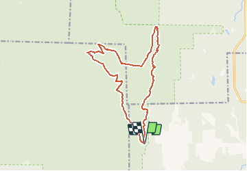
Trail Walking of 16.5 km to be discovered at Quebec, Le Granit, Notre-Dame-des-Bois. This trail is proposed by Alizée.pee.

Description

Le sentier commence tout d’abord par l’ascension vers le mont Saint-Joseph qui vous amène vers une petite chapelle très mignonne. Ensuite, vous allez rejoindre le mont Victoria par le Sentier des Crêtes (avec un dénivelé assez faible). Le sommet du Mont Victoria est assez boisé. Ensuite, le sentier continue vers le sommet du Mont Mégantic sur lequel se trouve l’Observatoire astronomique, à visiter ! Lorsque le temps est de la partie, il est possible d’observer depuis le sommet du Mont Mégantic, le Mont Orford. Après une petite pause pour observer la magnifique vue qui s’offre à vous, il vous suffit de redescendre vers le point d’arrivée en suivant les indications.

Elevation profile

Points of interest

Point of interest Notre-Dame-des-Bois - Stationnement - Photo
Alizée.pee
NOTRE-DAME-DES-BOIS 
Point of interest La Patrie - Refuge du Col-des-Trois-Sommets - Photo
Alizée.pee
Point of interest Val-Racine - Refuge des Pèlerins - Photo
Alizée.pee
Point of interest La Patrie - Observatoire populaire - Photo
Alizée.pee
Point of interest La Patrie - Observatoire astronomique - Photo
Alizée.pee
Point of interest Val-Racine - Mont Victoria - Photo
Alizée.pee
VAL-RACINE 
Point of interest Val-Racine - Mont Saint-Joseph - Photo
Alizée.pee
VAL-RACINE 
Point of interest Notre-Dame-des-Bois - Début du sentier - Photo
Alizée.pee
NOTRE-DAME-DES-BOIS 
Point of interest Val-Racine - Belvédère des crêtes - Photo
Alizée.pee

Positioning

Country:
Canada
Region :
Quebec
Department/Province :
Le Granit
Municipality :
Notre-Dame-des-Bois
Location:
Unknown
Start:(UTM)
333819 ; 5032206 (19T) N.

Trails nearby

Trail Walking Notre-Dame-des-Bois - Wikiloc - Cantons-de-l’Est - Parc national du Mont-Mégantic - Sentier du Mont-Saint-Joseph - Rando-Québec - Photo
Walking
GUIDE
Alizée.pee

Walking

Medium
Notre-Dame-des-Bois, Quebec, Le Granit, Canada
6.6 km | 12.9 km-effort
2h 34min
Yes
Trail Walking Notre-Dame-des-Bois - Wikiloc - mont Saint-Joseph - Photo
Walking
GUIDE
Alizée.pee

Walking

Difficult
Notre-Dame-des-Bois, Quebec, Le Granit, Canada
9.7 km | 16.3 km-effort
3h 19min
Yes
Trail Trail Notre-Dame-des-Bois - mont saint Joseph - Photo
Trail
Phil Paquet

Trail

Difficult
Notre-Dame-des-Bois, Quebec, Le Granit, Canada
7.3 km | 13.4 km-effort
3h 23min
Yes


Close
My subscriptions