Trail Walking Lac-Pikauba - 2014-10-11 13:54:29 - Photo

2014-10-11 13:54:29

 Alizée.pee
Alizée.pee

User GUIDE

© OpenStreetMap contributors
Length
Length
7.7 km
Max alt
Max alt
933 m
Uphill gradient
Uphill gradient
403 m
Km-Effort
Km-Effort  
13.1 km
Min alt
Min alt
603 m
Downhill gradient
Downhill gradient
402 m
Boucle
Boucle
Yes
Creation date :
2019-09-03 12:08:54.152
Updated on :
2019-09-03 12:10:47.394

(0 Reviews)

Walking
Walking
3h30
Difficulty : Easy

Scan this QR Code to open this trail in the SityTrail application

FREE GPS app for hiking

Logo SityTrail SityTrail

IGN / Geographical institutes

Download SityTrail from the App Store Download SityTrail from Google Play

Logo SityTrail SityTrail World

The world is yours!

Download SityTrail from the App Store Download SityTrail from Google Play Download SityTrail on Huawei AppGallery

About

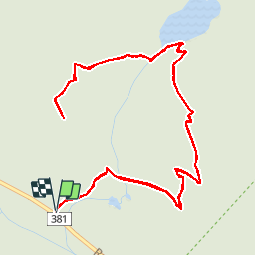
Trail Walking of 7.7 km to be discovered at Quebec, Charlevoix, Lac-Pikauba. This trail is proposed by Alizée.pee.

Description

Ce sentier permet de gravir un sommet d’où l’on peut admirer une magnifique vue vers la vallée du gouffre jusqu’au fleuve Saint-Laurent. Le sommet du Dôme offre une vue impressionnante sur la vallée des Grands-Jardins. Tout au long de la randonnée, de magnifiques paysages sont présents ainsi que de splendides points de vue sur les horizons. La randonnée est assez facile et très agréable grâce à la quiétude du lieu !

Elevation profile

Points of interest

Point of interest Lac-Pikauba - Stationnement - Photo
Alizée.pee
LAC-PIKAUBA 
Point of interest Lac-Pikauba - Sommet - Mont du Dôme - Photo
Alizée.pee
Point of interest Lac-Pikauba - Intersection 3 - Photo
Alizée.pee
LAC-PIKAUBA 
Point of interest Lac-Pikauba - Intersection 2 - Photo
Alizée.pee
LAC-PIKAUBA 
Point of interest Lac-Pikauba - Intersection 1 - Photo
Alizée.pee
LAC-PIKAUBA 

Positioning

Country:
Canada
Region :
Quebec
Department/Province :
Charlevoix
Municipality :
Lac-Pikauba
Location:
Unknown
Start:(UTM)
376809 ; 5282196 (19T) N.

Trails nearby

Trail Walking Lac-Pikauba - Trail Planner Map - Photo
Walking
GUIDE
Alizée.pee

Walking

Easy
Lac-Pikauba, Quebec, Charlevoix, Canada
4.7 km | 7.6 km-effort
1h 33min
Yes
Trail Cycle Lac-Pikauba - Mont du lac a L'Empeche - Photo
Cycle
GUIDE
Alizée.pee

Cycle

Medium
Lac-Pikauba, Quebec, Charlevoix, Canada
13.1 km | 21 km-effort
2h 0min
Yes
Trail Walking Lac-Pikauba - 10-AUG-13 - Photo
Walking
GUIDE
Alizée.pee

Walking

Medium
(1)
Lac-Pikauba, Quebec, Charlevoix, Canada
13.5 km | 22 km-effort
6h 0min
Yes
Trail Walking Lac-Pikauba - 12-AUG-13 - Photo
Walking
GUIDE
Alizée.pee

Walking

Medium
Lac-Pikauba, Quebec, Charlevoix, Canada
11.4 km | 19.4 km-effort
5h 0min
Yes
Trail Walking Lac-Pikauba - Wikiloc - Sentier la Chouenne - Parc national des grands jardins - Photo
Walking
GUIDE
Alizée.pee

Walking

Medium
(1)
Lac-Pikauba, Quebec, Charlevoix, Canada
4.6 km | 7.5 km-effort
1h 32min
Yes
Trail Walking Lac-Pikauba - Wikiloc - Parc National des Grands-Jardins - Sentier Le Pioui. - Photo
Walking
GUIDE
Alizée.pee

Walking

Difficult
Lac-Pikauba, Quebec, Charlevoix, Canada
10.8 km | 18.7 km-effort
3h 48min
Yes
Trail Walking Lac-Pikauba - Le mont du lac des cygnes - Photo
Walking
Tournan

Walking

Medium
Lac-Pikauba, Quebec, Charlevoix, Canada
4 km | 8.2 km-effort
1h 55min
No
Trail Walking Lac-Pikauba - mont du lac des cygnes - Photo
Walking
aldaus

Walking

Medium
Lac-Pikauba, Quebec, Charlevoix, Canada
12.1 km | 20 km-effort
5h 8min
Yes


Close
My subscriptions