Trail Walking Saint-Christophe-sur-Dolaison - Tallode St. Privat Allier - Photo
© OpenStreetMap contributors
Length
Length
14.5 km
Max alt
Max alt
1214 m
Uphill gradient
Uphill gradient
311 m
Km-Effort
Km-Effort  
18.9 km
Min alt
Min alt
872 m
Downhill gradient
Downhill gradient
364 m
Boucle
Boucle
No
Creation date :
2014-12-10 00:00:00.0
Updated on :
2014-12-10 00:00:00.0

(0 Reviews)

Walking
Walking
2h33
Difficulty : Medium

Scan this QR Code to open this trail in the SityTrail application

FREE GPS app for hiking

Logo SityTrail SityTrail

IGN / Geographical institutes

Download SityTrail from the App Store Download SityTrail from Google Play

Logo SityTrail SityTrail World

The world is yours!

Download SityTrail from the App Store Download SityTrail from Google Play Download SityTrail on Huawei AppGallery

About

Trail Walking of 14.5 km to be discovered at Auvergne-Rhône-Alpes, Haute-Loire, Saint-Christophe-sur-Dolaison. This trail is proposed by Kirikou92.

Description

Parti à 7 arrivée 9.30 et hop

Elevation profile

Positioning

Country:
France
Region :
Auvergne-Rhône-Alpes
Department/Province :
Haute-Loire
Municipality :
Saint-Christophe-sur-Dolaison
Location:
Unknown
Start:(UTM)
564024 ; 4982686 (31T) N.

Trails nearby

Trail Electric bike Vals-près-le-Puy - LP / Lac du Bouchet  - Photo
Electric bike
ricou1964

Electric bike

Medium
Vals-près-le-Puy, Auvergne-Rhône-Alpes, Haute-Loire, France
52 km | 64 km-effort
3h 55min
No
Trail Walking Cussac-sur-Loire - voie verte malpas  costaros - Photo
Walking
dudu42

Walking

Easy
Cussac-sur-Loire, Auvergne-Rhône-Alpes, Haute-Loire, France
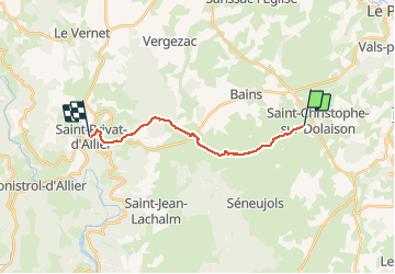
22 km | 28 km-effort
4h 35min
Yes
Trail Walking Vals-près-le-Puy - copostelle 07/08 - Photo
Walking
chantalwaltzer

Walking

Vals-près-le-Puy, Auvergne-Rhône-Alpes, Haute-Loire, France
28 km | 34 km-effort
6h 19min
No
Trail Coupling Bains - Bains matinée  - Photo
Coupling
BONDETTI

Coupling

Easy
Bains, Auvergne-Rhône-Alpes, Haute-Loire, France
15.8 km | 19.4 km-effort
2h 32min
No
Trail Mountain bike Solignac-sur-Loire - cascade de la vrai ma par voie verte - Photo
Mountain bike
sdy

Mountain bike

Easy
Solignac-sur-Loire, Auvergne-Rhône-Alpes, Haute-Loire, France
14.9 km | 17.9 km-effort
2h 2min
Yes
Trail Walking Espaly-Saint-Marcel - Puy en Velay - Fay - Photo
Walking
christian1957

Walking

Difficult
Espaly-Saint-Marcel, Auvergne-Rhône-Alpes, Haute-Loire, France
17.5 km | 22 km-effort
5h 57min
No
Trail Walking Saint-Christophe-sur-Dolaison - Le Puy-St. Privat - Photo
Walking
parrotdad

Walking

Medium
Saint-Christophe-sur-Dolaison, Auvergne-Rhône-Alpes, Haute-Loire, France
21 km | 27 km-effort
7h 3min
No
Trail Walking Vals-près-le-Puy - Trail vals - Photo
Walking
nanard223

Walking

Difficult
Vals-près-le-Puy, Auvergne-Rhône-Alpes, Haute-Loire, France
13 km | 18.2 km-effort
3h 32min
No
Trail Walking Bains - St Jacques J2 - Photo
Walking
madrepore

Walking

Very difficult
Bains, Auvergne-Rhône-Alpes, Haute-Loire, France
17.1 km | 23 km-effort
5h 52min
No


Close
My subscriptions