Trail Walking Saint-Philémon - Wikiloc - Chaudière-Appalaches - Parc régional du Massif du Sud - Sent... - Photo

Wikiloc - Chaudière-Appalaches - Parc régional du Massif du Sud - Sent...

 Alizée.pee
Alizée.pee

User GUIDE

© OpenStreetMap contributors
Length
Length
7.4 km
Max alt
Max alt
715 m
Uphill gradient
Uphill gradient
288 m
Km-Effort
Km-Effort  
11.3 km
Min alt
Min alt
441 m
Downhill gradient
Downhill gradient
289 m
Boucle
Boucle
Yes
Creation date :
2019-09-02 11:23:35.707
Updated on :
2019-09-02 11:24:32.006

(0 Reviews)

Walking
Walking
2h20
Difficulty : Medium

Scan this QR Code to open this trail in the SityTrail application

FREE GPS app for hiking

Logo SityTrail SityTrail

IGN / Geographical institutes

Download SityTrail from the App Store Download SityTrail from Google Play

Logo SityTrail SityTrail World

The world is yours!

Download SityTrail from the App Store Download SityTrail from Google Play Download SityTrail on Huawei AppGallery

About

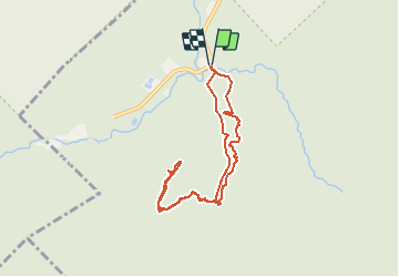
Trail Walking of 7.4 km to be discovered at Quebec, Bellechasse, Saint-Philémon. This trail is proposed by Alizée.pee.

Description

Sentier qui mène au sommet du Mont Chocolat. Il offre une boucle panoramique avec une vue imprenable sur la vallée du Milieu et les montagnes environnantes. Passage par des rivières, par le sentier du Milieu ainsi que le sentier de la Passerelle. Cette randonnée offre de splendides paysages.

Elevation profile

Positioning

Country:
Canada
Region :
Quebec
Department/Province :
Bellechasse
Municipality :
Saint-Philémon
Location:
Unknown
Start:(UTM)
387768 ; 5164994 (19T) N.

Trails nearby

Trail Walking Saint-Philémon - Gates of Hell Trail  - Photo
Walking
GUIDE
Alizée.pee

Walking

Difficult
Saint-Philémon, Quebec, Bellechasse, Canada
15.5 km | 25 km-effort
5h 7min
Yes


Close
My subscriptions