![](/images/other/stat-length.png)
![Trail Walking Gaspé - Wikiloc - Parc national du Canada-Forillon, parte sur - Photo](https://media.geolcdn.com/t/1900/400/ext.pjpeg?maxdim=2&url=https%3A%2F%2Fstatic1.geolcdn.com%2Fsiteimages%2Fupload%2Ffiles%2F1553511878bg_sport_marche.png)
Wikiloc - Parc national du Canada-Forillon, parte sur
Alizée.pee
User GUIDE
![Length](/images/other/stat-length.png)
Length
7.6 km
![Max alt](https://static1.geolcdn.com/siteimages/upload/files/1508320355ic_sort_altitude_max_24dp.png)
Max alt
100 m
![Uphill gradient](https://static1.geolcdn.com/siteimages/upload/files/1508320355ic_sort_den_pos_24dp.png)
Uphill gradient
217 m
![Km-Effort](/images/other/stat-length.png)
Km-Effort
10.5 km
![Min alt](https://static1.geolcdn.com/siteimages/upload/files/1508320355ic_sort_altitude_min_24dp.png)
Min alt
2 m
![Downhill gradient](https://static1.geolcdn.com/siteimages/upload/files/1508320355ic_sort_den_neg_24dp.png)
Downhill gradient
217 m
![Boucle](https://static1.geolcdn.com/siteimages/upload/files/16400158638029165_repeat_loop_refresh_sync_direction_icon.png)
Boucle
Yes
Creation date :
2019-09-02 11:20:27.264
Updated on :
2019-09-02 11:21:36.161
![Walking](https://static1.geolcdn.com/sitytour/trail-icons/101.png)
2h13
Difficulty : Medium
![Scan this QR Code to open this trail in the SityTrail application](https://capi.geolives.com/qq0zvz2zws4bq2lad0pu/sitytour/trails/2189365/qr.png?size=200)
FREE GPS app for hiking
About
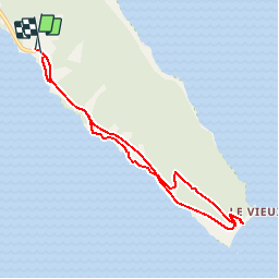
Trail Walking of 7.6 km to be discovered at Quebec, La Côte-de-Gaspé, Gaspé. This trail is proposed by Alizée.pee.
Description
Ce sentier mène au phare situé à l’extrémité du parc et offre un point de vue extraordinaire sur le golfe à partir duquel on peut contempler des baleines ainsi que certains phoques. C'est une très belle randonnée avec de très jolis paysages.
Positioning
Country:
Canada
Region :
Quebec
Department/Province :
La Côte-de-Gaspé
Municipality :
Gaspé
Location:
Unknown
Start:(Dec)
Start:(UTM)
412266 ; 5402495 (20U) N.
Comments
Trails nearby
![Trail Walking Gaspé - Sommet Mont Alban - Photo](https://media.geolcdn.com/t/375/260/ext.jpg?maxdim=2&url=https%3A%2F%2Fstatic1.geolcdn.com%2Fsiteimages%2Fupload%2Ffiles%2F1553511878bg_sport_marche.png)
![Walking Walking](https://static1.geolcdn.com/sitytour/trail-icons/101.png)
Sommet Mont Alban
Walking
Difficult
Gaspé,
Quebec,
La Côte-de-Gaspé,
Canada
![](/images/other/stat-length.png)
8.3 km | 13.8 km-effort
2h 49min
![](https://static1.geolcdn.com/siteimages/upload/files/16400158638029165_repeat_loop_refresh_sync_direction_icon.png)
Yes
![Trail Walking Gaspé - Wikiloc - Mont St-Alban, parc Forillon, Gaspésie - Photo](https://media.geolcdn.com/t/375/260/ext.jpg?maxdim=2&url=https%3A%2F%2Fstatic1.geolcdn.com%2Fsiteimages%2Fupload%2Ffiles%2F1553511878bg_sport_marche.png)
![Walking Walking](https://static1.geolcdn.com/sitytour/trail-icons/101.png)
Wikiloc - Mont St-Alban, parc Forillon, Gaspésie
Walking
Difficult
Gaspé,
Quebec,
La Côte-de-Gaspé,
Canada
![](/images/other/stat-length.png)
8.9 km | 15.3 km-effort
3h 6min
![](https://static1.geolcdn.com/siteimages/upload/files/16400158638029165_repeat_loop_refresh_sync_direction_icon.png)
Yes
![Trail Walking Gaspé - Forillon - Photo](https://media.geolcdn.com/t/375/260/ext.jpg?maxdim=2&url=https%3A%2F%2Fstatic1.geolcdn.com%2Fsiteimages%2Fupload%2Ffiles%2F1553511878bg_sport_marche.png)
![Walking Walking](https://static1.geolcdn.com/sitytour/trail-icons/101.png)
Forillon
Walking
Very easy
Gaspé,
Quebec,
La Côte-de-Gaspé,
Canada
![](/images/other/stat-length.png)
8.3 km | 13.6 km-effort
Unknown
![](https://static1.geolcdn.com/siteimages/upload/files/16400158638029165_repeat_loop_refresh_sync_direction_icon.png)
Yes
![Trail Walking Gaspé - Tour du Mont-Alban - Gaspésie - Photo](https://media.geolcdn.com/t/375/260/ext.jpg?maxdim=2&url=https%3A%2F%2Fstatic1.geolcdn.com%2Fsiteimages%2Fupload%2Ffiles%2F1553511878bg_sport_marche.png)
![Walking Walking](https://static1.geolcdn.com/sitytour/trail-icons/101.png)
Tour du Mont-Alban - Gaspésie
Walking
Medium
Gaspé,
Quebec,
La Côte-de-Gaspé,
Canada
![](/images/other/stat-length.png)
7.1 km | 11.6 km-effort
2h 5min
![](https://static1.geolcdn.com/siteimages/upload/files/16400158638029165_repeat_loop_refresh_sync_direction_icon.png)
Yes
![Trail Walking Gaspé - cap Gaspé - Photo](https://media.geolcdn.com/t/375/260/ext.jpg?maxdim=2&url=https%3A%2F%2Fstatic1.geolcdn.com%2Fsiteimages%2Fupload%2Ffiles%2F1553511878bg_sport_marche.png)
![Walking Walking](https://static1.geolcdn.com/sitytour/trail-icons/101.png)
cap Gaspé
Walking
Medium
Gaspé,
Quebec,
La Côte-de-Gaspé,
Canada
![](/images/other/stat-length.png)
7.8 km | 10.3 km-effort
2h 23min
![](https://static1.geolcdn.com/siteimages/upload/files/16400158638029165_repeat_loop_refresh_sync_direction_icon.png)
Yes
![Trail Walking Gaspé - Mont Saint Alban depuis la grande grave - Photo](https://media.geolcdn.com/t/375/260/ext.jpg?maxdim=2&url=https%3A%2F%2Fstatic1.geolcdn.com%2Fsiteimages%2Fupload%2Ffiles%2F1553511878bg_sport_marche.png)
![Walking Walking](https://static1.geolcdn.com/sitytour/trail-icons/101.png)
Mont Saint Alban depuis la grande grave
Walking
Medium
Gaspé,
Quebec,
La Côte-de-Gaspé,
Canada
![](/images/other/stat-length.png)
7.7 km | 12.2 km-effort
2h 13min
![](https://static1.geolcdn.com/siteimages/upload/files/16400158638029165_repeat_loop_refresh_sync_direction_icon.png)
Yes
![Trail Walking Gaspé - Gaspé Tour du Mt Alban - Photo](https://media.geolcdn.com/t/375/260/ext.jpg?maxdim=2&url=https%3A%2F%2Fstatic1.geolcdn.com%2Fsiteimages%2Fupload%2Ffiles%2F1553511878bg_sport_marche.png)
![Walking Walking](https://static1.geolcdn.com/sitytour/trail-icons/101.png)
Gaspé Tour du Mt Alban
Walking
Easy
Gaspé,
Quebec,
La Côte-de-Gaspé,
Canada
![](/images/other/stat-length.png)
8.2 km | 12.9 km-effort
2h 39min
![](https://static1.geolcdn.com/siteimages/upload/files/16400158638029165_repeat_loop_refresh_sync_direction_icon.png)
Yes