


Tuc Tuc Lac Toba

Sigmut
User
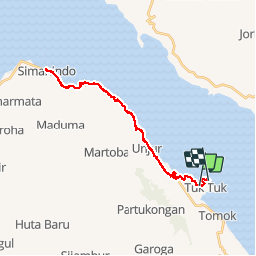

Length
45 km

Max alt
963 m

Uphill gradient
493 m
Km-Effort
52 km

Min alt
905 m

Downhill gradient
501 m
Boucle
No
Creation date :
2014-12-11 00:00:00.0
Updated on :
2014-12-11 00:00:00.0
7h34
Difficulty : Medium

FREE GPS app for hiking
 SityTrail
IGN / Geographical institutes
SityTrail World
The world is yours!
About
Trail Cycle of 45 km to be discovered at North Sumatra. This trail is proposed by Sigmut.
Photos

Positioning
Country:
Indonesia
Region :
North Sumatra
Department/Province :
Unknown
Municipality :
Unknown
Location:
Unknown
Start:(Dec)
Start:(UTM)
483216 ; 295474 (47N) N.
Comments
Trails nearby