Trail Cycle Bondoufle - PERSO. LA RONDE DES CHATEAUX EN CENTRE ESSONNE - Photo

PERSO. LA RONDE DES CHATEAUX EN CENTRE ESSONNE

© OpenStreetMap contributors
Length
Length
151 km
Max alt
Max alt
169 m
Uphill gradient
Uphill gradient
1486 m
Km-Effort
Km-Effort  
171 km
Min alt
Min alt
47 m
Downhill gradient
Downhill gradient
1486 m
Boucle
Boucle
Yes
Creation date :
2019-08-31 18:03:45.88
Updated on :
2019-08-31 18:05:34.869

(0 Reviews)

Cycle
Cycle
--
Difficulty : Difficult

Scan this QR Code to open this trail in the SityTrail application

FREE GPS app for hiking

Logo SityTrail SityTrail

IGN / Geographical institutes

Download SityTrail from the App Store Download SityTrail from Google Play

Logo SityTrail SityTrail World

The world is yours!

Download SityTrail from the App Store Download SityTrail from Google Play Download SityTrail on Huawei AppGallery

About

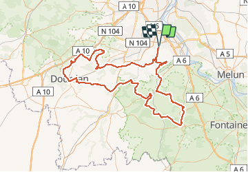
Trail Cycle of 151 km to be discovered at Ile-de-France, Essonne, Bondoufle. This trail is proposed by Lucquiaud.

Description

randonnée permanente de Bondoufle ( corrigée après Dourdan )

Elevation profile

Positioning

Country:
France
Region :
Ile-de-France
Department/Province :
Essonne
Municipality :
Bondoufle
Location:
Unknown
Start:(UTM)
454090 ; 5384745 (31U) N.

Trails nearby

Trail Walking Écharcon - Autour de Vert le Petit - Photo
Walking
tracegps

Walking

Medium
(1)
Écharcon, Ile-de-France, Essonne, France
16 km | 17.9 km-effort
4h 0min
Yes
Trail Mountain bike Bondoufle - rando
Mountain bike
marsupio

Mountain bike

Easy
(1)
Bondoufle, Ile-de-France, Essonne, France
56 km | 63 km-effort
8min
Yes
Trail Mountain bike Bondoufle - Senart - Photo
Mountain bike
godmer

Mountain bike

Very difficult
(1)
Bondoufle, Ile-de-France, Essonne, France
46 km | 52 km-effort
3h 30min
Yes
Trail Mountain bike Bondoufle - Sortie club du 29/09/2019 - Photo
Mountain bike
godmer

Mountain bike

Difficult
(1)
Bondoufle, Ile-de-France, Essonne, France
32 km | 36 km-effort
2h 25min
Yes
Trail Walking Fleury-Mérogis - Fleury-Méfrogis - Forêt Régionale de Saint-Eutrope - Photo
Walking
guydu41

Walking

Easy
Fleury-Mérogis, Ile-de-France, Essonne, France
6.3 km | 7 km-effort
1h 35min
Yes
Trail On foot Soisy-sur-Seine - Boucle Soisy / Seine / Sénart  - Photo
On foot
GUIDE
chessyca

On foot

Very easy
Soisy-sur-Seine, Ile-de-France, Essonne, France
18.6 km | 21 km-effort
4h 49min
Yes
Trail sport Mennecy - De Mennecy à Corbeil-Essonnes par le Parc de Robinson - Photo
sport
Annie Leduc

sport

Very easy
(1)
Mennecy, Ile-de-France, Essonne, France
13.1 km | 14.6 km-effort
Unknown
No
Trail Mountain bike Bondoufle - Autodrome - Photo
Mountain bike
mamath1491

Mountain bike

Very difficult
(1)
Bondoufle, Ile-de-France, Essonne, France
48 km | 54 km-effort
3h 44min
Yes
Trail Mountain bike Bondoufle - Bondoufle -Baulne  58KM - Photo
Mountain bike
godmer

Mountain bike

Easy
(1)
Bondoufle, Ile-de-France, Essonne, France
58 km | 66 km-effort
4h 34min
No


Close
My subscriptions