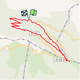
Trail Walking Noyers-sur-Jabron - Boucle versant nord de Lure - Photo
 HSB-GLC
HSB-GLC

User

© OpenStreetMap contributors
Length
Length
9.8 km
Max alt
Max alt
1598 m
Uphill gradient
Uphill gradient
466 m
Km-Effort
Km-Effort  
16 km
Min alt
Min alt
1208 m
Downhill gradient
Downhill gradient
460 m
Boucle
Boucle
Yes
Creation date :
2019-08-29 07:57:52.0
Updated on :
2019-08-30 11:11:22.903

(0 Reviews)

Walking
Walking
5h35
Difficulty : Unknown

Scan this QR Code to open this trail in the SityTrail application

FREE GPS app for hiking

Logo SityTrail SityTrail

IGN / Geographical institutes

Download SityTrail from the App Store Download SityTrail from Google Play

Logo SityTrail SityTrail World

The world is yours!

Download SityTrail from the App Store Download SityTrail from Google Play Download SityTrail on Huawei AppGallery

About

Trail Walking of 9.8 km to be discovered at Provence-Alpes-Côte d'Azur, Alpes-de-Haute-Provence, Noyers-sur-Jabron. This trail is proposed by HSB-GLC.

Description

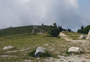
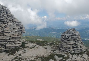
Le dernier raidillon pour arriver au col de la Graille est vraiment très raide !

Elevation profile

Positioning

Country:
France
Region :
Provence-Alpes-Côte d'Azur
Department/Province :
Alpes-de-Haute-Provence
Municipality :
Noyers-sur-Jabron
Location:
Unknown
Start:(UTM)
724970 ; 4890309 (31T) N.

Trails nearby

Trail Walking Valbelle - chapelle saint Pont et montagne Sumiou - Photo
Walking
GUIDE
nadd73

Walking

Difficult
Valbelle, Provence-Alpes-Côte d'Azur, Alpes-de-Haute-Provence, France
21 km | 34 km-effort
5h 11min
Yes
Trail On foot Noyers-sur-Jabron - Montagne de Sumiou - Grotte des Peyrouets_19_01_2024 - Photo
On foot
GUIDE
R@ph

On foot

Medium
Noyers-sur-Jabron, Provence-Alpes-Côte d'Azur, Alpes-de-Haute-Provence, France
16 km | 24 km-effort
5h 32min
Yes
Trail On foot Valbelle - Montagne de Lure - Photo
On foot
GUIDE
Marco05

On foot

Difficult
Valbelle, Provence-Alpes-Côte d'Azur, Alpes-de-Haute-Provence, France
20 km | 35 km-effort
7h 54min
Yes
Trail Walking Saint-Étienne-les-Orgues - LURE .Montagne de Lure . Crêtes de LURE. Pas de  la Graille. Cairn  2000 .Co  o  mbe de la Sapee - Photo
Walking
RobinMicheline

Walking

Medium
(3)
Saint-Étienne-les-Orgues, Provence-Alpes-Côte d'Azur, Alpes-de-Haute-Provence, France
16.3 km | 26 km-effort
5h 41min
Yes
Trail Walking Noyers-sur-Jabron - Montagne de Lure (boucle) - Photo
Walking
neitag61

Walking

Difficult
(2)
Noyers-sur-Jabron, Provence-Alpes-Côte d'Azur, Alpes-de-Haute-Provence, France
12.6 km | 21 km-effort
4h 0min
Yes
Trail Walking Cruis - Essai 3 - Photo
Walking
patrickbeyrath

Walking

Medium
(1)
Cruis, Provence-Alpes-Côte d'Azur, Alpes-de-Haute-Provence, France
4.1 km | 7.2 km-effort
1h 37min
No
Trail Walking Saint-Étienne-les-Orgues - Montagne de Lure, le Cairn 2000. - Photo
Walking
liocol

Walking

Medium
Saint-Étienne-les-Orgues, Provence-Alpes-Côte d'Azur, Alpes-de-Haute-Provence, France
6 km | 8.7 km-effort
2h 46min
No
Trail Walking Saint-Étienne-les-Orgues -  Lure 15kms 830m - Photo
Walking
GUIDE
Danielba

Walking

Easy
Saint-Étienne-les-Orgues, Provence-Alpes-Côte d'Azur, Alpes-de-Haute-Provence, France
14.8 km | 25 km-effort
6h 55min
Yes
Trail Walking Noyers-sur-Jabron - Pas du long Rocher - Montagne de Pélegrine - Pas des portes 18/02/24 - Photo
Walking
GUIDE
R@ph

Walking

Very difficult
Noyers-sur-Jabron, Provence-Alpes-Côte d'Azur, Alpes-de-Haute-Provence, France
19.3 km | 32 km-effort
7h 15min
Yes


Close
My subscriptions