


clearwater lake

Bertrand Simon
User
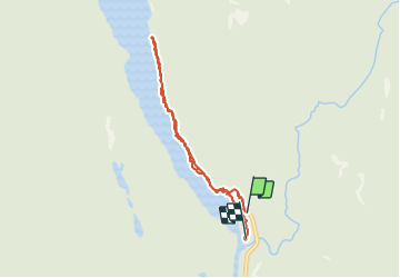

Length
6.2 km

Max alt
717 m

Uphill gradient
118 m
Km-Effort
7.8 km

Min alt
680 m

Downhill gradient
124 m
Boucle
No
Creation date :
2019-08-26 16:56:44.846
Updated on :
2019-08-27 23:08:55.383
2h53
Difficulty : Very easy

FREE GPS app for hiking
 SityTrail
IGN / Geographical institutes
SityTrail World
The world is yours!
About
Trail Walking of 6.2 km to be discovered at British Columbia, Thompson-Nicola Regional District, Area A (Wells Gray Country). This trail is proposed by Bertrand Simon.
Positioning
Country:
Canada
Region :
British Columbia
Department/Province :
Thompson-Nicola Regional District
Municipality :
Area A (Wells Gray Country)
Location:
Unknown
Start:(Dec)
Start:(UTM)
692250 ; 5780385 (10U) N.
Comments
Trails nearby