Trail Walking Aucun - pic de Bazes  - Photo
 pffrench
pffrench

User

© OpenStreetMap contributors
Length
Length
7.2 km
Max alt
Max alt
1774 m
Uphill gradient
Uphill gradient
381 m
Km-Effort
Km-Effort  
12.6 km
Min alt
Min alt
1363 m
Downhill gradient
Downhill gradient
480 m
Boucle
Boucle
No
Creation date :
2019-08-26 09:03:15.66
Updated on :
2019-08-29 17:43:09.864

(0 Reviews)

Walking
Walking
5h19
Difficulty : Medium

Scan this QR Code to open this trail in the SityTrail application

FREE GPS app for hiking

Logo SityTrail SityTrail

IGN / Geographical institutes

Download SityTrail from the App Store Download SityTrail from Google Play

Logo SityTrail SityTrail World

The world is yours!

Download SityTrail from the App Store Download SityTrail from Google Play Download SityTrail on Huawei AppGallery

About

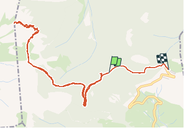
Trail Walking of 7.2 km to be discovered at Occitania, Hautespyrenees, Aucun. This trail is proposed by pffrench.

Description

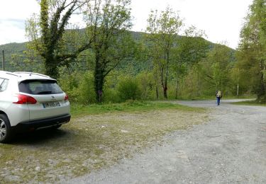
Le trajet est légèrement plus long, car l'enregistrement a été commencé après 2 km de marche environ ; pour cette raison, le dénivelé positif est en fait égal au dénivelé négatif. Nous avons emprunté le trajet balisé qui monte et descend abruptement. Pas de difficultés techniques, même s'il faut mettre les mains en arrivant au sommet, mais il faut avoir le pied sûr.
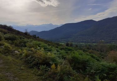
Au sommet, vue panoramique, sur les sommets,  sur le val d'Azun , et sur la vallée de Ferrière.

Elevation profile

Photos

Positioning

Country:
France
Region :
Occitania
Department/Province :
Hautespyrenees
Municipality :
Aucun
Location:
Unknown
Start:(UTM)
727250 ; 4763500 (30T) N.

Trails nearby

Trail Walking Arcizans-Dessus - la fontaine de Nabias - Photo
Walking
bernardbelmas

Walking

Very easy
(1)
Arcizans-Dessus, Occitania, Hautespyrenees, France
4.2 km | 6.8 km-effort
1h 40min
Yes
Trail Snowshoes Aucun - Le Soum de Berducou - Photo
Snowshoes
tracegps

Snowshoes

Medium
(1)
Aucun, Occitania, Hautespyrenees, France
5.3 km | 9.6 km-effort
3h 15min
Yes
Trail Walking Gaillagos - GAILLAGOS / Couret / Couraduque en boucle reco G3 - Photo
Walking
GUIDE
marmotte65

Walking

Difficult
Gaillagos, Occitania, Hautespyrenees, France
8.4 km | 14.3 km-effort
2h 30min
Yes
Trail Walking Salles - SALLES Le col d'Andorre avec nos voisins pierrefittois - Photo
Walking
GUIDE
marmotte65

Walking

Difficult
Salles, Occitania, Hautespyrenees, France
7.5 km | 13.2 km-effort
2h 52min
Yes
Trail Walking Arrens-Marsous - ARRENS MARSOUS Le Turon des aulhes    2906361 - Photo
Walking
GUIDE
marmotte65

Walking

Medium
(1)
Arrens-Marsous, Occitania, Hautespyrenees, France
9.5 km | 16.4 km-effort
5h 55min
Yes
Trail On foot Salles - SALLES-ARGELES col d'Andorre et soum de Leiz (ou pas)  2796042 - Photo
On foot
GUIDE
marmotte65

On foot

Easy
Salles, Occitania, Hautespyrenees, France
8.2 km | 14 km-effort
3h 10min
Yes
Trail Winter sports Aucun - couraduc soulor - Photo
Winter sports
ehresmann

Winter sports

Difficult
(1)
Aucun, Occitania, Hautespyrenees, France
34 km | 45 km-effort
2h 31min
Yes
Trail Winter sports Aucun - Bazes soulor - Photo
Winter sports
ehresmann

Winter sports

Medium
(1)
Aucun, Occitania, Hautespyrenees, France
25 km | 34 km-effort
2h 4min
Yes
Trail Walking Arrens-Marsous - col de soulor, lac de soum, col de bazes, col de soulor  - Photo
Walking
fbienmuller

Walking

Medium
Arrens-Marsous, Occitania, Hautespyrenees, France
16.4 km | 23 km-effort
5h 20min
Yes


Close
My subscriptions