Trail Walking Unknown - Wikiloc - CAN 15-Lago Maligno y Bald Hills // Maligne Lake and Bald Hi... - Photo

Wikiloc - CAN 15-Lago Maligno y Bald Hills // Maligne Lake and Bald Hi...

 Alizée.pee
Alizée.pee

User GUIDE

© OpenStreetMap contributors
Length
Length
11.9 km
Max alt
Max alt
2318 m
Uphill gradient
Uphill gradient
633 m
Km-Effort
Km-Effort  
20 km
Min alt
Min alt
1687 m
Downhill gradient
Downhill gradient
633 m
Boucle
Boucle
Yes
Creation date :
2019-08-26 13:29:59.914
Updated on :
2019-08-26 13:33:58.88

(0 Reviews)

Walking
Walking
4h08
Difficulty : Medium

Scan this QR Code to open this trail in the SityTrail application

FREE GPS app for hiking

Logo SityTrail SityTrail

IGN / Geographical institutes

Download SityTrail from the App Store Download SityTrail from Google Play

Logo SityTrail SityTrail World

The world is yours!

Download SityTrail from the App Store Download SityTrail from Google Play Download SityTrail on Huawei AppGallery

About

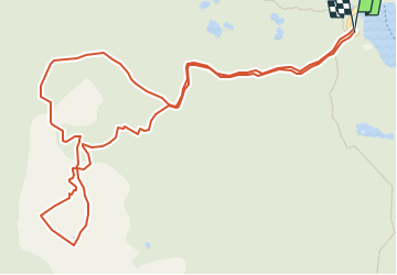
Trail Walking of 11.9 km to be discovered at Alberta, Improvement District No. 12. This trail is proposed by Alizée.pee.

Description

La randonnée commence par le Lac Maligne. Ensuite, l'ascension commence. Néanmoins, elle parait plus compliquée que ce qu'elle n'est en réalité. C'est un sentier assez facile et avec une splendide végétation. Vous aurez peut être la chance de voir des ours !
Une fois en haut, vous avez la vue sur le Lac Maligne mais également la vue sur tous les alentours qui en valent la peine !

Elevation profile

Positioning

Country:
Canada
Region :
Alberta
Department/Province :
Improvement District No. 12
Municipality :
Unknown
Location:
Unknown
Start:(UTM)
456459 ; 5842023 (11U) N.

Trails nearby

Trail Trail  - Lac Maligne - Photo
Trail
Bertrand Simon

Trail

Very easy
, Alberta, Improvement District No. 12, Canada
16.3 km | 0 m-effort
3h 9min
No


Close
My subscriptions