


Wikiloc - Haggertys Cove

Alizée.pee
User GUIDE
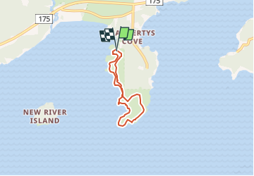

Length
4.7 km

Max alt
22 m

Uphill gradient
60 m
Km-Effort
5.5 km

Min alt
-1 m

Downhill gradient
53 m
Boucle
Yes
Creation date :
2019-08-26 13:03:10.558
Updated on :
2019-08-26 13:05:45.806
1h12
Difficulty : Easy

FREE GPS app for hiking
 SityTrail
IGN / Geographical institutes
SityTrail World
The world is yours!
About
Trail Walking of 4.7 km to be discovered at New Brunswick, Lepreau Parish. This trail is proposed by Alizée.pee.
Description
Une jolie et agréable randonnée avec une belle vue sur l'océan et des forêts. Il y a également une grande variété de fleur. C'est une randonnée qui en vaut la peine !
Positioning
Country:
Canada
Region :
New Brunswick
Department/Province :
Lepreau Parish
Municipality :
Carrying Cove
Location:
Unknown
Start:(Dec)
Start:(UTM)
694601 ; 5000456 (19T) N.
Comments
Trails nearby