![](/images/other/stat-length.png)
![Trail Walking Unknown - Wikiloc - CAN 17-Los cinco lagos // The Five Lakes - Photo](https://media.geolcdn.com/t/1900/400/ext.pjpeg?maxdim=2&url=https%3A%2F%2Fstatic1.geolcdn.com%2Fsiteimages%2Fupload%2Ffiles%2F1553511878bg_sport_marche.png)
Wikiloc - CAN 17-Los cinco lagos // The Five Lakes
Alizée.pee
User GUIDE
![Length](/images/other/stat-length.png)
Length
8.3 km
![Max alt](https://static1.geolcdn.com/siteimages/upload/files/1508320355ic_sort_altitude_max_24dp.png)
Max alt
1166 m
![Uphill gradient](https://static1.geolcdn.com/siteimages/upload/files/1508320355ic_sort_den_pos_24dp.png)
Uphill gradient
197 m
![Km-Effort](/images/other/stat-length.png)
Km-Effort
10.9 km
![Min alt](https://static1.geolcdn.com/siteimages/upload/files/1508320355ic_sort_altitude_min_24dp.png)
Min alt
1079 m
![Downhill gradient](https://static1.geolcdn.com/siteimages/upload/files/1508320355ic_sort_den_neg_24dp.png)
Downhill gradient
197 m
![Boucle](https://static1.geolcdn.com/siteimages/upload/files/16400158638029165_repeat_loop_refresh_sync_direction_icon.png)
Boucle
Yes
Creation date :
2019-08-26 12:47:34.085
Updated on :
2019-08-26 12:49:59.044
![Walking](https://static1.geolcdn.com/sitytour/trail-icons/101.png)
2h19
Difficulty : Medium
![Scan this QR Code to open this trail in the SityTrail application](https://capi.geolives.com/qq0zvz2zws4bq2lad0pu/sitytour/trails/2183578/qr.png?size=200)
FREE GPS app for hiking
About
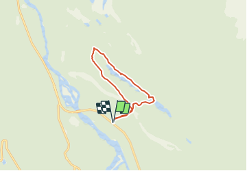
Trail Walking of 8.3 km to be discovered at Alberta, Municipality of Jasper. This trail is proposed by Alizée.pee.
Description
Sentier assez simple qui offre de belles vues. C'est un parc magnifique qui permet de se détendre. Les lacs sont superbes avec de l'eau claire. Randonnée familiale, malgré quelques montées, elle reste simple !
Positioning
Country:
Canada
Region :
Alberta
Department/Province :
Municipality of Jasper
Municipality :
Unknown
Location:
Unknown
Start:(Dec)
Start:(UTM)
431014 ; 5851458 (11U) N.
Comments
Trails nearby
![Trail Walking - Wikiloc - Pyramid island. Jasper National Park. - Photo](https://media.geolcdn.com/t/375/260/ext.jpg?maxdim=2&url=https%3A%2F%2Fstatic1.geolcdn.com%2Fsiteimages%2Fupload%2Ffiles%2F1553511878bg_sport_marche.png)
![Walking Walking](https://static1.geolcdn.com/sitytour/trail-icons/101.png)
Wikiloc - Pyramid island. Jasper National Park.
Walking
Easy
,
Alberta,
Municipality of Jasper,
Canada
![](/images/other/stat-length.png)
676 m | 756 m-effort
10min
![](https://static1.geolcdn.com/siteimages/upload/files/16400158638029165_repeat_loop_refresh_sync_direction_icon.png)
Yes