![Trail Walking Macamic - Wikiloc - Sentiers de la montagne à Fred - Photo](https://media.geolcdn.com/t/1900/400/ext.pjpeg?maxdim=2&url=https%3A%2F%2Fstatic1.geolcdn.com%2Fsiteimages%2Fupload%2Ffiles%2F1553511878bg_sport_marche.png)
Wikiloc - Sentiers de la montagne à Fred
Alizée.pee
User GUIDE
![Length](/images/other/stat-length.png)
Length
5.1 km
![Max alt](https://static1.geolcdn.com/siteimages/upload/files/1508320355ic_sort_altitude_max_24dp.png)
Max alt
356 m
![Uphill gradient](https://static1.geolcdn.com/siteimages/upload/files/1508320355ic_sort_den_pos_24dp.png)
Uphill gradient
108 m
![Km-Effort](/images/other/stat-length.png)
Km-Effort
6.5 km
![Min alt](https://static1.geolcdn.com/siteimages/upload/files/1508320355ic_sort_altitude_min_24dp.png)
Min alt
288 m
![Downhill gradient](https://static1.geolcdn.com/siteimages/upload/files/1508320355ic_sort_den_neg_24dp.png)
Downhill gradient
111 m
![Boucle](https://static1.geolcdn.com/siteimages/upload/files/16400158638029165_repeat_loop_refresh_sync_direction_icon.png)
Boucle
Yes
Creation date :
2019-08-26 12:37:47.664
Updated on :
2019-08-26 12:39:51.288
![Walking](https://static1.geolcdn.com/sitytour/trail-icons/101.png)
1h23
Difficulty : Medium
![Scan this QR Code to open this trail in the SityTrail application](https://capi.geolives.com/qq0zvz2zws4bq2lad0pu/sitytour/trails/2183565/qr.png?size=200)
FREE GPS app for hiking
About
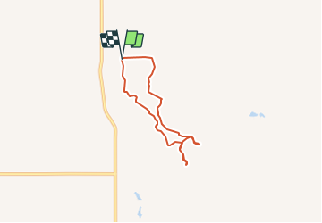
Trail Walking of 5.1 km to be discovered at Quebec, Abitibi-Ouest, Macamic. This trail is proposed by Alizée.pee.
Description
Ce sentier est très caillouteux et est accompagné d'une végétation incroyable. A certains moments, il vous faudra passer sur des petits pontons en bois, c'est un moment sympathique. Le dénivelé est assez faible.
Positioning
Country:
Canada
Region :
Quebec
Department/Province :
Abitibi-Ouest
Municipality :
Macamic
Location:
Unknown
Start:(Dec)
Start:(UTM)
636867 ; 5399583 (17U) N.
Comments
Trails nearby