


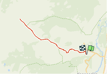
Wikiloc - Centenial Trail: Mount Allan

Alizée.pee
User GUIDE


6h34
Difficulty : Very difficult

FREE GPS app for hiking
 SityTrail
IGN / Geographical institutes
SityTrail World
The world is yours!
About
Trail Walking of 14.8 km to be discovered at Alberta, Kananaskis Improvement District. This trail is proposed by Alizée.pee.
Description
Cette randonnée demande beaucoup d'effort en raison de ses kilomètres ainsi que le dénivelé. Une fois arrivé au sommet du Mont Allan, vous avez une vue panoramique qui s'offre à vous ! Vous aurez aussi la possibilité de voir des cols de montagnes avec de gros rochers ressemblant à de gros dinausores, connu sous le nom de "Rock Garden".
Positioning
Comments
Trails nearby