![](/images/other/stat-length.png)
![Trail Walking Rouyn-Noranda - Wikiloc - Sentiers des collines Kékéko - Photo](https://media.geolcdn.com/t/1900/400/ext.pjpeg?maxdim=2&url=https%3A%2F%2Fstatic1.geolcdn.com%2Fsiteimages%2Fupload%2Ffiles%2F1553511878bg_sport_marche.png)
Wikiloc - Sentiers des collines Kékéko
Alizée.pee
User GUIDE
![Length](/images/other/stat-length.png)
Length
16.9 km
![Max alt](https://static1.geolcdn.com/siteimages/upload/files/1508320355ic_sort_altitude_max_24dp.png)
Max alt
481 m
![Uphill gradient](https://static1.geolcdn.com/siteimages/upload/files/1508320355ic_sort_den_pos_24dp.png)
Uphill gradient
599 m
![Km-Effort](/images/other/stat-length.png)
Km-Effort
25 km
![Min alt](https://static1.geolcdn.com/siteimages/upload/files/1508320355ic_sort_altitude_min_24dp.png)
Min alt
276 m
![Downhill gradient](https://static1.geolcdn.com/siteimages/upload/files/1508320355ic_sort_den_neg_24dp.png)
Downhill gradient
597 m
![Boucle](https://static1.geolcdn.com/siteimages/upload/files/16400158638029165_repeat_loop_refresh_sync_direction_icon.png)
Boucle
Yes
Creation date :
2019-08-26 10:42:42.795
Updated on :
2019-08-26 10:46:09.226
![Walking](https://static1.geolcdn.com/sitytour/trail-icons/101.png)
5h12
Difficulty : Very difficult
![Scan this QR Code to open this trail in the SityTrail application](https://capi.geolives.com/qq0zvz2zws4bq2lad0pu/sitytour/trails/2183457/qr.png?size=200)
FREE GPS app for hiking
About
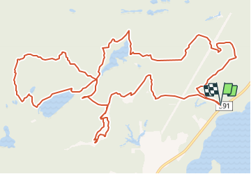
Trail Walking of 16.9 km to be discovered at Quebec, Unknown, Rouyn-Noranda. This trail is proposed by Alizée.pee.
Description
Cette randonnée passe par de nombreux endroits aussi jolis les uns que les autres. Cette randonnée passe par de nombreux sentiers connus tels que le sentier des remparts ou encore celui de la falaise. IL offre de magnifiques panorama du lac Hector et du lac Despérier. Longue randonnée mais qui en vaut le coup d'oeil.
Positioning
Country:
Canada
Region :
Quebec
Department/Province :
Unknown
Municipality :
Rouyn-Noranda
Location:
Unknown
Start:(Dec)
Start:(UTM)
638679 ; 5337727 (17U) N.
Comments
Trails nearby
![Trail Snowshoes Rouyn-Noranda - Seul - Photo](https://media.geolcdn.com/t/375/260/ext.jpg?maxdim=2&url=https%3A%2F%2Fstatic1.geolcdn.com%2Fsiteimages%2Fupload%2Ffiles%2F1524743153raquette.jpg)
![Snowshoes Snowshoes](https://static1.geolcdn.com/sitytour/trail-icons/504.png)
![Trail Snowshoes Rouyn-Noranda - Randonnée avec Louise et Claire - Photo](https://media.geolcdn.com/t/375/260/ext.jpg?maxdim=2&url=https%3A%2F%2Fstatic1.geolcdn.com%2Fsiteimages%2Fupload%2Ffiles%2F1524743153raquette.jpg)
![Snowshoes Snowshoes](https://static1.geolcdn.com/sitytour/trail-icons/504.png)
Randonnée avec Louise et Claire
Snowshoes
Rouyn-Noranda,
Quebec,
Unknown,
Canada
![](/images/other/stat-length.png)
5.5 km | 6 km-effort
2h 37min
![](https://static1.geolcdn.com/siteimages/upload/files/16400158638029165_repeat_loop_refresh_sync_direction_icon.png)
Yes
![Trail Walking Rouyn-Noranda - Valérie - Photo](https://media.geolcdn.com/t/375/260/ext.jpg?maxdim=2&url=https%3A%2F%2Fstatic1.geolcdn.com%2Fsiteimages%2Fupload%2Ffiles%2F1553511878bg_sport_marche.png)
![Walking Walking](https://static1.geolcdn.com/sitytour/trail-icons/101.png)