![](/images/other/stat-length.png)
![Trail Walking Sainte-Foy-Tarentaise - Le Monal - Photo](https://media.geolcdn.com/t/1900/400/ext.pjpeg?maxdim=2&url=https%3A%2F%2Fstatic1.geolcdn.com%2Fsiteimages%2Fupload%2Ffiles%2F1553511878bg_sport_marche.png)
Le Monal
sperchant
User
![Length](/images/other/stat-length.png)
Length
31 km
![Boucle](https://static1.geolcdn.com/siteimages/upload/files/16400158638029165_repeat_loop_refresh_sync_direction_icon.png)
Boucle
No
Creation date :
2019-08-24 15:13:04.0
Updated on :
2019-08-24 18:19:09.55
![Walking](https://static1.geolcdn.com/sitytour/trail-icons/101.png)
3h05
Difficulty : Easy
![Scan this QR Code to open this trail in the SityTrail application](https://capi.geolives.com/qq0zvz2zws4bq2lad0pu/sitytour/trails/2181813/qr.png?size=200)
FREE GPS app for hiking
About
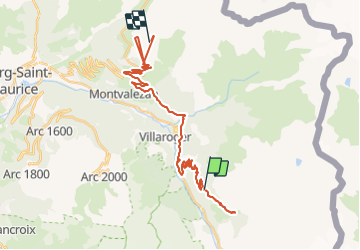
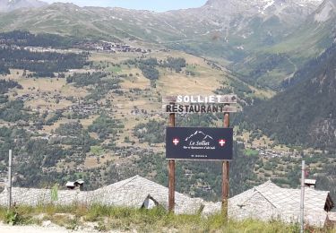
Trail Walking of 31 km to be discovered at Auvergne-Rhône-Alpes, Savoy, Sainte-Foy-Tarentaise. This trail is proposed by sperchant.
Description
Version courte depuis le parking au plus haut. Faisable en 1:39 Max aller retour.
Possibilité de faire depuis le village-station Le Bon Conseil. Compter 2:45 aller simple.
Positioning
Country:
France
Region :
Auvergne-Rhône-Alpes
Department/Province :
Savoy
Municipality :
Sainte-Foy-Tarentaise
Location:
Unknown
Start:(Dec)
Start:(UTM)
336256 ; 5047927 (32T) N.
Comments
Trails nearby
![Trail Walking Sainte-Foy-Tarentaise - le lac du Clou par le Monal - Photo](https://media.geolcdn.com/t/375/260/ext.jpg?maxdim=2&url=https%3A%2F%2Fservices.sitytrail.com%2FGeolivesWS%2FDownloadMedia.ashx%3FTrailID%3D462593%26Media%3Dfix__20150822160630.jpg)
![Walking Walking](https://static1.geolcdn.com/sitytour/trail-icons/101.png)
le lac du Clou par le Monal
Walking
Easy
(1)
Sainte-Foy-Tarentaise,
Auvergne-Rhône-Alpes,
Savoy,
France
![](/images/other/stat-length.png)
12.2 km | 22 km-effort
6h 20min
![](https://static1.geolcdn.com/siteimages/upload/files/16400158638029165_repeat_loop_refresh_sync_direction_icon.png)
Yes
![Trail Walking Villaroger - le refuge de Turia et l'approche du glacier de la Gurraz - Photo](https://media.geolcdn.com/t/375/260/ext.jpg?maxdim=2&url=https%3A%2F%2Fservices.sitytrail.com%2FGeolivesWS%2FDownloadMedia.ashx%3FTrailID%3D1031304%26Media%3Dfix__20180830104725.jpg)
![Walking Walking](https://static1.geolcdn.com/sitytour/trail-icons/101.png)
le refuge de Turia et l'approche du glacier de la Gurraz
Walking
Medium
Villaroger,
Auvergne-Rhône-Alpes,
Savoy,
France
![](/images/other/stat-length.png)
11.7 km | 26 km-effort
5h 2min
![](https://static1.geolcdn.com/siteimages/upload/files/16400158638029165_repeat_loop_refresh_sync_direction_icon.png)
Yes
![Trail Walking Villaroger - 73 Tarentaise Villaroger Planey - Photo](https://media.geolcdn.com/t/375/260/ext.jpg?maxdim=2&url=https%3A%2F%2Fstatic1.geolcdn.com%2Fsiteimages%2Fupload%2Ffiles%2F1553511878bg_sport_marche.png)
![Walking Walking](https://static1.geolcdn.com/sitytour/trail-icons/101.png)
73 Tarentaise Villaroger Planey
Walking
Medium
(1)
Villaroger,
Auvergne-Rhône-Alpes,
Savoy,
France
![](/images/other/stat-length.png)
7.7 km | 16.9 km-effort
3h 50min
![](https://static1.geolcdn.com/siteimages/upload/files/16400158638029165_repeat_loop_refresh_sync_direction_icon.png)
Yes
![Trail Walking Sainte-Foy-Tarentaise - Col de l'aiguille par le lac du clou - Photo](https://media.geolcdn.com/t/375/260/3cdfc5c6-f6c6-4fe9-a47f-d04cd82fdb34.jpg&format=jpg&maxdim=2)
![Walking Walking](https://static1.geolcdn.com/sitytour/trail-icons/101.png)
Col de l'aiguille par le lac du clou
Walking
Medium
(1)
Sainte-Foy-Tarentaise,
Auvergne-Rhône-Alpes,
Savoy,
France
![](/images/other/stat-length.png)
11.9 km | 23 km-effort
4h 49min
![](https://static1.geolcdn.com/siteimages/upload/files/16400158638029165_repeat_loop_refresh_sync_direction_icon.png)
Yes
![Trail Walking Sainte-Foy-Tarentaise - Chenal Monal Clou Fenil (boucle) - Photo](https://media.geolcdn.com/t/375/260/7c8dfcdb-f2ec-45bb-b6ab-d2fab85d008b.jpg&format=jpg&maxdim=2)
![Walking Walking](https://static1.geolcdn.com/sitytour/trail-icons/101.png)
Chenal Monal Clou Fenil (boucle)
Walking
Medium
Sainte-Foy-Tarentaise,
Auvergne-Rhône-Alpes,
Savoy,
France
![](/images/other/stat-length.png)
10.4 km | 17.8 km-effort
3h 3min
![](https://static1.geolcdn.com/siteimages/upload/files/16400158638029165_repeat_loop_refresh_sync_direction_icon.png)
Yes
![Trail Walking Sainte-Foy-Tarentaise - Bon conseil lac du Clou - Photo](https://media.geolcdn.com/t/375/260/e35dae35-19b9-4b63-908a-208274fb6e76.jpg&format=jpg&maxdim=2)
![Walking Walking](https://static1.geolcdn.com/sitytour/trail-icons/101.png)
Bon conseil lac du Clou
Walking
Very difficult
(1)
Sainte-Foy-Tarentaise,
Auvergne-Rhône-Alpes,
Savoy,
France
![](/images/other/stat-length.png)
16.1 km | 29 km-effort
6h 6min
![](https://static1.geolcdn.com/siteimages/upload/files/16400158638029165_repeat_loop_refresh_sync_direction_icon.png)
Yes
![Trail Walking Sainte-Foy-Tarentaise - Le Monial lac du clos en boucle randonnée très facile - Photo](https://media.geolcdn.com/t/375/260/693c7cdb-79a2-4cdc-af86-543514d84fda.jpg&format=jpg&maxdim=2)
![Walking Walking](https://static1.geolcdn.com/sitytour/trail-icons/101.png)
Le Monial lac du clos en boucle randonnée très facile
Walking
Easy
Sainte-Foy-Tarentaise,
Auvergne-Rhône-Alpes,
Savoy,
France
![](/images/other/stat-length.png)
10.6 km | 19.2 km-effort
5h 16min
![](https://static1.geolcdn.com/siteimages/upload/files/16400158638029165_repeat_loop_refresh_sync_direction_icon.png)
No
![Trail Walking Sainte-Foy-Tarentaise - Des bataillettes à plan dessous - Photo](https://media.geolcdn.com/t/375/260/0f9717a3-974f-4d61-9ce7-acd65fddf569.jpg&format=jpg&maxdim=2)
![Walking Walking](https://static1.geolcdn.com/sitytour/trail-icons/101.png)
Des bataillettes à plan dessous
Walking
Easy
Sainte-Foy-Tarentaise,
Auvergne-Rhône-Alpes,
Savoy,
France
![](/images/other/stat-length.png)
5.8 km | 9.1 km-effort
2h 16min
![](https://static1.geolcdn.com/siteimages/upload/files/16400158638029165_repeat_loop_refresh_sync_direction_icon.png)
Yes
![Trail Walking Villaroger - les souliers, plan de l'aiguille refuge de Turia - Photo](https://media.geolcdn.com/t/375/260/ext.jpg?maxdim=2&url=https%3A%2F%2Fservices.sitytrail.com%2FGeolivesWS%2FDownloadMedia.ashx%3FTrailID%3D1006214%26Media%3Dfix__20180718150319.jpg)
![Walking Walking](https://static1.geolcdn.com/sitytour/trail-icons/101.png)
les souliers, plan de l'aiguille refuge de Turia
Walking
Medium
Villaroger,
Auvergne-Rhône-Alpes,
Savoy,
France
![](/images/other/stat-length.png)
13.4 km | 26 km-effort
5h 15min
![](https://static1.geolcdn.com/siteimages/upload/files/16400158638029165_repeat_loop_refresh_sync_direction_icon.png)
Yes