Trail On foot Yerres - Rando douce 6 km en foêt de la Grange, Yerres - Photo

Rando douce 6 km en foêt de la Grange, Yerres

 Surot
Surot

User

© OpenStreetMap contributors
Length
Length
6.1 km
Max alt
Max alt
118 m
Uphill gradient
Uphill gradient
55 m
Km-Effort
Km-Effort  
6.8 km
Min alt
Min alt
88 m
Downhill gradient
Downhill gradient
53 m
Boucle
Boucle
Yes
Creation date :
2019-08-24 12:51:08.557
Updated on :
2019-08-24 13:04:08.127

(0 Reviews)

On foot
On foot
--
Difficulty : Very easy

Scan this QR Code to open this trail in the SityTrail application

FREE GPS app for hiking

Logo SityTrail SityTrail

IGN / Geographical institutes

Download SityTrail from the App Store Download SityTrail from Google Play

Logo SityTrail SityTrail World

The world is yours!

Download SityTrail from the App Store Download SityTrail from Google Play Download SityTrail on Huawei AppGallery

About

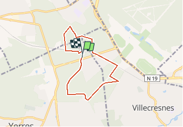
Trail On foot of 6.1 km to be discovered at Ile-de-France, Essonne, Yerres. This trail is proposed by Surot.

Description

Petite boucle facile en forêt essentiellement avec très peu de dénivelé (descendant!), pour randonneurs fragiles. 6 km

Elevation profile

Positioning

Country:
France
Region :
Ile-de-France
Department/Province :
Essonne
Municipality :
Yerres
Location:
Unknown
Start:(UTM)
463870 ; 5397783 (31U) N.

Trails nearby

Trail Walking Marolles-en-Brie - GRP CV-IDF 05 - Photo
Walking
clalaur

Walking

Difficult
(1)
Marolles-en-Brie, Ile-de-France, Val-de-Marne, France
13.5 km | 15.2 km-effort
3h 27min
No
Trail Walking Mandres-les-Roses - J 26 Mandres, Boussy , Brunoy le chemin des fresques  - Photo
Walking

Walking

Medium
(2)
Mandres-les-Roses, Ile-de-France, Val-de-Marne, France
12.2 km | 13.8 km-effort
3h 7min
Yes
Trail Walking Yerres - BM Foret Regionale de Grobois 10km - Photo
Walking
GUIDE
jeanmarcMasson

Walking

Medium
(1)
Yerres, Ile-de-France, Essonne, France
10.4 km | 11 km-effort
2h 30min
Yes
Trail Walking Yerres - BM Foret Regionale Grosbois 10km - Photo
Walking
GUIDE
jeanmarcMasson

Walking

Medium
(1)
Yerres, Ile-de-France, Essonne, France
9.8 km | 10.5 km-effort
2h 23min
Yes
Trail On foot Brunoy - L 39 Brunoy, les bords de l'Yerres - Photo
On foot

On foot

Very easy
(4)
Brunoy, Ile-de-France, Essonne, France
5.4 km | 6.1 km-effort
1h 49min
Yes
Trail On foot Boussy-Saint-Antoine - L 32: Boussy St Antoine l'Yerres et le Gord - Photo
On foot

On foot

Very easy
(3)
Boussy-Saint-Antoine, Ile-de-France, Essonne, France
6.2 km | 7.2 km-effort
1h 38min
Yes
Trail Walking Yerres - J 43  Yerres Parc Caillebotte, île des Prévôts - Photo
Walking

Walking

Medium
(2)
Yerres, Ile-de-France, Essonne, France
11.4 km | 13.1 km-effort
2h 59min
Yes
Trail Walking Marolles-en-Brie - Balade en forêt Domaniale Notre Dame - Photo
Walking
caro94

Walking

Easy
(1)
Marolles-en-Brie, Ile-de-France, Val-de-Marne, France
8.6 km | 9.3 km-effort
2h 3min
Yes
Trail Walking Yerres - Boucle 30 km Sénart et bords de l'YERRES - Photo
Walking
GUIDE
chessyca

Walking

Very difficult
Yerres, Ile-de-France, Essonne, France
30 km | 33 km-effort
8h 10min
Yes


Close
My subscriptions