Trail Mountain bike Lachapelle-aux-Pots - ACTIVE LOG 003 - Photo
 sebcar
sebcar

User

© OpenStreetMap contributors
Length
Length
19.1 km
Max alt
Max alt
237 m
Uphill gradient
Uphill gradient
374 m
Km-Effort
Km-Effort  
24 km
Min alt
Min alt
84 m
Downhill gradient
Downhill gradient
374 m
Boucle
Boucle
Yes
Creation date :
2019-08-23 18:13:09.798
Updated on :
2019-08-24 12:49:18.958

(1 Reviews)

Mountain bike
Mountain bike
1h39
Difficulty : Medium

Scan this QR Code to open this trail in the SityTrail application

FREE GPS app for hiking

Logo SityTrail SityTrail

IGN / Geographical institutes

Download SityTrail from the App Store Download SityTrail from Google Play

Logo SityTrail SityTrail World

The world is yours!

Download SityTrail from the App Store Download SityTrail from Google Play Download SityTrail on Huawei AppGallery

About

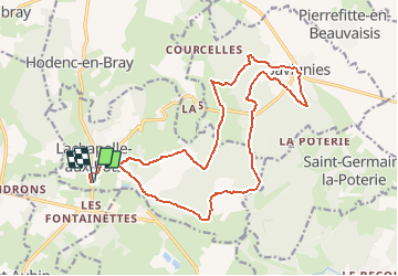
Trail Mountain bike of 19.1 km to be discovered at Hauts-de-France, Oise, Lachapelle-aux-Pots. This trail is proposed by sebcar.

Description

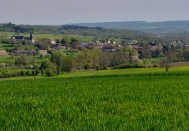
Belle façon de découvrir les caractéristiques paysagères et géologiques du flanc est du pays de Bray.
Attention à Lhuyère le chemin à disparu suite à un "remembrement personnalisé" du cultivateur.

Elevation profile

Positioning

Country:
France
Region :
Hauts-de-France
Department/Province :
Oise
Municipality :
Lachapelle-aux-Pots
Location:
Unknown
Start:(UTM)
420392 ; 5477224 (31U) N.

Comments

Please log in to post a review or rate the element


Trails nearby

Trail Mountain bike Pierrefitte-en-Beauvaisis - Grand tour - Photo
Mountain bike
jjeletufe

Mountain bike

(1)
Pierrefitte-en-Beauvaisis, Hauts-de-France, Oise, France
30 km | 35 km-effort
1h 44min
Yes
Trail Walking Senantes - Senantes - Photo
Walking
jpblimond

Walking

Medium
Senantes, Hauts-de-France, Oise, France
18.7 km | 23 km-effort
4h 47min
Yes
Trail Walking Savignies - savignies - Photo
Walking
Novomarquiens

Walking

Easy
Savignies, Hauts-de-France, Oise, France
9.3 km | 12 km-effort
3h 0min
Yes
Trail Walking Lalandelle - Lalandelle - La boutonnière du pays de Bray - Photo
Walking
Marie-Claire-mcp

Walking

Difficult
Lalandelle, Hauts-de-France, Oise, France
10.4 km | 12.5 km-effort
2h 50min
Yes
Trail Walking Lalandelle - Forêt domaniale de Thelle à partir de Lalandelle - Photo
Walking
Marie-Claire-mcp

Walking

Difficult
Lalandelle, Hauts-de-France, Oise, France
11 km | 13.1 km-effort
2h 59min
Yes
Trail Walking Lachapelle-aux-Pots - Lachapelle-aux-pots - Héricourt - La Frénoye - Armentières - Photo
Walking
Marie-Claire-mcp

Walking

Difficult
Lachapelle-aux-Pots, Hauts-de-France, Oise, France
10.7 km | 13.7 km-effort
3h 6min
Yes
Trail Walking Lachapelle-aux-Pots - Lachapelle aux pots - Armentières 11 km - Photo
Walking
Marie-Claire-mcp

Walking

Difficult
Lachapelle-aux-Pots, Hauts-de-France, Oise, France
10.6 km | 13.5 km-effort
3h 4min
Yes
Trail Walking Lachapelle-aux-Pots - Lachapelle aux Pots - Rando santé 1 - Photo
Walking
marcel.F

Walking

Medium
Lachapelle-aux-Pots, Hauts-de-France, Oise, France
5.6 km | 6.4 km-effort
1h 24min
Yes
Trail Walking Lachapelle-aux-Pots - Lachapelle-aux-Pots - autour de la Crapaudière vers 2 - Photo
Walking
marcel.F

Walking

Easy
Lachapelle-aux-Pots, Hauts-de-France, Oise, France
9.9 km | 11.5 km-effort
2h 32min
Yes


Close
My subscriptions