Trail Walking Lac-Supérieur - Wikiloc - Mont Nixon - Lac Supérieur - Photo

Wikiloc - Mont Nixon - Lac Supérieur

 Alizée.pee
Alizée.pee

User GUIDE

© OpenStreetMap contributors
Length
Length
8.7 km
Max alt
Max alt
658 m
Uphill gradient
Uphill gradient
444 m
Km-Effort
Km-Effort  
14.6 km
Min alt
Min alt
358 m
Downhill gradient
Downhill gradient
444 m
Boucle
Boucle
Yes
Creation date :
2019-08-23 14:13:23.388
Updated on :
2019-08-23 14:16:19.598

(0 Reviews)

Walking
Walking
2h59
Difficulty : Difficult

Scan this QR Code to open this trail in the SityTrail application

FREE GPS app for hiking

Logo SityTrail SityTrail

IGN / Geographical institutes

Download SityTrail from the App Store Download SityTrail from Google Play

Logo SityTrail SityTrail World

The world is yours!

Download SityTrail from the App Store Download SityTrail from Google Play Download SityTrail on Huawei AppGallery

About

Trail Walking of 8.7 km to be discovered at Quebec, Les Laurentides, Lac-Supérieur. This trail is proposed by Alizée.pee.

Description

Ce sentier vous fera passer par différents paysages, tous plus magnifiques les uns que les autres.

Elevation profile

Positioning

Country:
Canada
Region :
Quebec
Department/Province :
Les Laurentides
Municipality :
Lac-Supérieur
Location:
Unknown
Start:(UTM)
541589 ; 5120550 (18T) N.

Trails nearby

Trail Walking Lac-Supérieur - Wikiloc - LE CENTENAIRE - Photo
Walking
GUIDE
Alizée.pee

Walking

Very difficult
Lac-Supérieur, Quebec, Les Laurentides, Canada
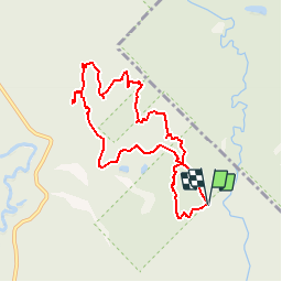
13.6 km | 21 km-effort
4h 21min
Yes


Close
My subscriptions