


Wikiloc - Hunt Lake Trail April 2015

Alizée.pee
User GUIDE
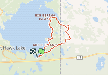

Length
13.1 km

Max alt
372 m

Uphill gradient
193 m
Km-Effort
15.7 km

Min alt
330 m

Downhill gradient
193 m
Boucle
Yes
Creation date :
2019-08-23 13:49:13.914
Updated on :
2019-08-23 13:52:29.377
3h25
Difficulty : Difficult

FREE GPS app for hiking
 SityTrail
IGN / Geographical institutes
SityTrail World
The world is yours!
About
Trail Walking of 13.1 km to be discovered at Manitoba. This trail is proposed by Alizée.pee.
Description
Randonnée qui longe le rivage du lac Hunt. Le sentier transporte de la frontière Ontario jusqu'au spectaculaire Bouclier Canadien. Il y a quelques sections pentues mais qui vous amènent à de magnifiques points de vue !
Positioning
Country:
Canada
Region :
Manitoba
Department/Province :
Unknown
Municipality :
Unknown
Location:
Unknown
Start:(Dec)
Start:(UTM)
342950 ; 5511996 (15U) N.
Comments
Trails nearby