![](/images/other/stat-length.png)
![Trail Walking Mont-Albert - Wikiloc - Mont xalibu - Photo](https://media.geolcdn.com/t/1900/400/ext.pjpeg?maxdim=2&url=https%3A%2F%2Fstatic1.geolcdn.com%2Fsiteimages%2Fupload%2Ffiles%2F1553511878bg_sport_marche.png)
Wikiloc - Mont xalibu
Alizée.pee
User GUIDE
![Length](/images/other/stat-length.png)
Length
12.3 km
![Max alt](https://static1.geolcdn.com/siteimages/upload/files/1508320355ic_sort_altitude_max_24dp.png)
Max alt
1135 m
![Uphill gradient](https://static1.geolcdn.com/siteimages/upload/files/1508320355ic_sort_den_pos_24dp.png)
Uphill gradient
573 m
![Km-Effort](/images/other/stat-length.png)
Km-Effort
19.9 km
![Min alt](https://static1.geolcdn.com/siteimages/upload/files/1508320355ic_sort_altitude_min_24dp.png)
Min alt
600 m
![Downhill gradient](https://static1.geolcdn.com/siteimages/upload/files/1508320355ic_sort_den_neg_24dp.png)
Downhill gradient
573 m
![Boucle](https://static1.geolcdn.com/siteimages/upload/files/16400158638029165_repeat_loop_refresh_sync_direction_icon.png)
Boucle
Yes
Creation date :
2019-08-22 12:32:39.04
Updated on :
2019-08-22 12:34:57.47
![Walking](https://static1.geolcdn.com/sitytour/trail-icons/101.png)
4h05
Difficulty : Difficult
![Scan this QR Code to open this trail in the SityTrail application](https://capi.geolives.com/qq0zvz2zws4bq2lad0pu/sitytour/trails/2179177/qr.png?size=200)
FREE GPS app for hiking
About
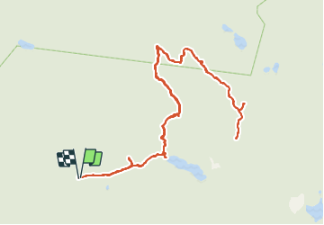
Trail Walking of 12.3 km to be discovered at Quebec, La Haute-Gaspésie, Mont-Albert. This trail is proposed by Alizée.pee.
Description
Situé dans le parc national de la Gaspésie, le Mont-Xalibu est un des plus hauts sommets des monts Notre-Dame. La randonnée offre une magnifique vue d'un lac. L'ascension n'est pas des plus simples mais elle en vaut la peine !
Positioning
Country:
Canada
Region :
Quebec
Department/Province :
La Haute-Gaspésie
Municipality :
Mont-Albert
Location:
Unknown
Start:(Dec)
Start:(UTM)
716479 ; 5426637 (19U) N.
Comments
Trails nearby
![Trail Walking Mont-Albert - 2014-08-10 18:36:31 - Photo](https://media.geolcdn.com/t/375/260/ext.jpg?maxdim=2&url=https%3A%2F%2Fstatic1.geolcdn.com%2Fsiteimages%2Fupload%2Ffiles%2F1553511878bg_sport_marche.png)
![Walking Walking](https://static1.geolcdn.com/sitytour/trail-icons/101.png)
2014-08-10 18:36:31
Walking
Easy
(1)
Mont-Albert,
Quebec,
La Haute-Gaspésie,
Canada
![](/images/other/stat-length.png)
4.5 km | 7 km-effort
1h 50min
![](https://static1.geolcdn.com/siteimages/upload/files/16400158638029165_repeat_loop_refresh_sync_direction_icon.png)
Yes
![Trail Walking Mont-Albert - Wikiloc - Parc National de la Gaspésie - Sentier du Mont Richardson - Aller-retour - Photo](https://media.geolcdn.com/t/375/260/ext.jpg?maxdim=2&url=https%3A%2F%2Fstatic1.geolcdn.com%2Fsiteimages%2Fupload%2Ffiles%2F1553511878bg_sport_marche.png)
![Walking Walking](https://static1.geolcdn.com/sitytour/trail-icons/101.png)
Wikiloc - Parc National de la Gaspésie - Sentier du Mont Richardson - Aller-r...
Walking
Very difficult
Mont-Albert,
Quebec,
La Haute-Gaspésie,
Canada
![](/images/other/stat-length.png)
11.6 km | 22 km-effort
4h 26min
![](https://static1.geolcdn.com/siteimages/upload/files/16400158638029165_repeat_loop_refresh_sync_direction_icon.png)
Yes
![Trail Walking Mont-Albert - Wikiloc - Parc National de la Gaspésie - Mont Ernest Laforce - Photo](https://media.geolcdn.com/t/375/260/ext.jpg?maxdim=2&url=https%3A%2F%2Fstatic1.geolcdn.com%2Fsiteimages%2Fupload%2Ffiles%2F1553511878bg_sport_marche.png)
![Walking Walking](https://static1.geolcdn.com/sitytour/trail-icons/101.png)
Wikiloc - Parc National de la Gaspésie - Mont Ernest Laforce
Walking
Medium
Mont-Albert,
Quebec,
La Haute-Gaspésie,
Canada
![](/images/other/stat-length.png)
5.5 km | 8.6 km-effort
1h 46min
![](https://static1.geolcdn.com/siteimages/upload/files/16400158638029165_repeat_loop_refresh_sync_direction_icon.png)
Yes
![Trail Walking Mont-Albert - Tour du mont Ernest Laforce - Photo](https://media.geolcdn.com/t/375/260/ext.jpg?maxdim=2&url=https%3A%2F%2Fstatic1.geolcdn.com%2Fsiteimages%2Fupload%2Ffiles%2F1553511878bg_sport_marche.png)
![Walking Walking](https://static1.geolcdn.com/sitytour/trail-icons/101.png)
Tour du mont Ernest Laforce
Walking
Very easy
Mont-Albert,
Quebec,
La Haute-Gaspésie,
Canada
![](/images/other/stat-length.png)
7.8 km | 11.1 km-effort
1h 15min
![](https://static1.geolcdn.com/siteimages/upload/files/16400158638029165_repeat_loop_refresh_sync_direction_icon.png)
No
![Trail Walking Mont-Albert - mont xalibu - Gaspésie - Photo](https://media.geolcdn.com/t/375/260/ext.jpg?maxdim=2&url=https%3A%2F%2Fstatic1.geolcdn.com%2Fsiteimages%2Fupload%2Ffiles%2F1553511878bg_sport_marche.png)
![Walking Walking](https://static1.geolcdn.com/sitytour/trail-icons/101.png)
mont xalibu - Gaspésie
Walking
Medium
Mont-Albert,
Quebec,
La Haute-Gaspésie,
Canada
![](/images/other/stat-length.png)
11.3 km | 18.6 km-effort
2h 51min
![](https://static1.geolcdn.com/siteimages/upload/files/16400158638029165_repeat_loop_refresh_sync_direction_icon.png)
No
![Trail Walking Mont-Albert - mont Ernest Laforce - Photo](https://media.geolcdn.com/t/375/260/ext.jpg?maxdim=2&url=https%3A%2F%2Fstatic1.geolcdn.com%2Fsiteimages%2Fupload%2Ffiles%2F1553511878bg_sport_marche.png)
![Walking Walking](https://static1.geolcdn.com/sitytour/trail-icons/101.png)
mont Ernest Laforce
Walking
Easy
Mont-Albert,
Quebec,
La Haute-Gaspésie,
Canada
![](/images/other/stat-length.png)
4.8 km | 7.3 km-effort
1h 30min
![](https://static1.geolcdn.com/siteimages/upload/files/16400158638029165_repeat_loop_refresh_sync_direction_icon.png)
Yes
![Trail Walking Mont-Albert - mont ernest laforce - Photo](https://media.geolcdn.com/t/375/260/ext.jpg?maxdim=2&url=https%3A%2F%2Fstatic1.geolcdn.com%2Fsiteimages%2Fupload%2Ffiles%2F1553511878bg_sport_marche.png)
![Walking Walking](https://static1.geolcdn.com/sitytour/trail-icons/101.png)
mont ernest laforce
Walking
Easy
Mont-Albert,
Quebec,
La Haute-Gaspésie,
Canada
![](/images/other/stat-length.png)
4.7 km | 7.1 km-effort
1h 46min
![](https://static1.geolcdn.com/siteimages/upload/files/16400158638029165_repeat_loop_refresh_sync_direction_icon.png)
Yes
![Trail Walking Mont-Albert - Mt Ernest Laforce Parc de Gaspésie - Photo](https://media.geolcdn.com/t/375/260/ext.jpg?maxdim=2&url=https%3A%2F%2Fstatic1.geolcdn.com%2Fsiteimages%2Fupload%2Ffiles%2F1553511878bg_sport_marche.png)
![Walking Walking](https://static1.geolcdn.com/sitytour/trail-icons/101.png)
Mt Ernest Laforce Parc de Gaspésie
Walking
Easy
Mont-Albert,
Quebec,
La Haute-Gaspésie,
Canada
![](/images/other/stat-length.png)
5 km | 7.5 km-effort
1h 33min
![](https://static1.geolcdn.com/siteimages/upload/files/16400158638029165_repeat_loop_refresh_sync_direction_icon.png)
Yes
![Trail Walking Mont-Albert - CANADA PARK GASPESIE Mont Ernest_2018_10_02 - Photo](https://media.geolcdn.com/t/375/260/ext.jpg?maxdim=2&url=https%3A%2F%2Fstatic1.geolcdn.com%2Fsiteimages%2Fupload%2Ffiles%2F1553511878bg_sport_marche.png)
![Walking Walking](https://static1.geolcdn.com/sitytour/trail-icons/101.png)
CANADA PARK GASPESIE Mont Ernest_2018_10_02
Walking
Very easy
Mont-Albert,
Quebec,
La Haute-Gaspésie,
Canada
![](/images/other/stat-length.png)
4.3 km | 6.8 km-effort
Unknown
![](https://static1.geolcdn.com/siteimages/upload/files/16400158638029165_repeat_loop_refresh_sync_direction_icon.png)
Yes