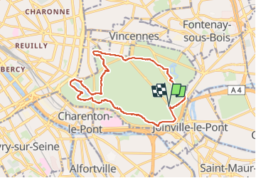
15.9 km | 17.1 km-effort
Bois de Vincennes
Surot
User
Length
14.6 km
Max alt
73 m
Uphill gradient
110 m
Km-Effort
16 km
Min alt
42 m
Downhill gradient
113 m
Boucle
Yes
Creation date :
2019-08-21 08:29:52.0
Updated on :
2023-04-16 15:55:13.58
3h38
Difficulty : Difficult
FREE GPS app for hiking
About
Trail Walking of 14.6 km to be discovered at Ile-de-France, Paris, Paris. This trail is proposed by Surot.
Description
Boucle de 13-14km dans le bois de Vincennes par chacun des 4 lacs
Positioning
Country:
France
Region :
Ile-de-France
Department/Province :
Paris
Municipality :
Paris
Location:
12th Arrondissement
Start:(Dec)
Start:(UTM)
460107 ; 5408138 (31U) N.
Comments
Trails nearby
Neuilly Plaisance gare Rer sortie Bords de Marne/ Base Nautique Vaires sur Marne
Walking
Easy
(1)
Neuilly-Plaisance,
Ile-de-France,
Seine-Saint-Denis,
France
2h 52min
Yes
DP75-07 De Maraîchers au carrefour Daumesnil - Hecto-Malot
Walking
Easy
(1)
Paris,
Ile-de-France,
Paris,
France
4.8 km | 5.4 km-effort
1h 13min
No
Randopolitain les bords de Marne 18 km
Walking
Easy
Saint-Maur-des-Fossés,
Ile-de-France,
Val-de-Marne,
France
17.2 km | 18.8 km-effort
4h 2min
No
Nation - Cité des sciences
Walking
Difficult
(1)
Paris,
Ile-de-France,
Paris,
France
13.1 km | 16 km-effort
3h 38min
No
JC 84 - La Végétale - 18,2 km
On foot
Difficult
(1)
Créteil,
Ile-de-France,
Val-de-Marne,
France
18.3 km | 21 km-effort
4h 40min
No
Sur les bords de Marne
On foot
Medium
Champigny-sur-Marne,
Ile-de-France,
Val-de-Marne,
France
32 km | 35 km-effort
7h 52min
Yes
Rando à thème : le père Lachaise + la campagne à Paris
On foot
Easy
Paris,
Ile-de-France,
Paris,
France
8.6 km | 10.1 km-effort
2h 17min
No
Boucle St Maur - Vincennes
Walking
Saint-Maur-des-Fossés,
Ile-de-France,
Val-de-Marne,
France
22 km | 24 km-effort
5h 32min
Yes
Guinguettes du val de Marne depuis Vincennes
On foot
Easy
Vincennes,
Ile-de-France,
Val-de-Marne,
France
20 km | 22 km-effort
5h 0min
No