Trail Walking Saint-Geyrac - 10 août 2018 08:48:52 - Photo

10 août 2018 08:48:52

 YV24
YV24

User

© OpenStreetMap contributors
Length
Length
8.9 km
Max alt
Max alt
253 m
Uphill gradient
Uphill gradient
185 m
Km-Effort
Km-Effort  
11.3 km
Min alt
Min alt
169 m
Downhill gradient
Downhill gradient
182 m
Boucle
Boucle
Yes
Creation date :
2019-08-20 17:00:31.578
Updated on :
2019-09-14 13:30:26.34

(0 Reviews)

Walking
Walking
2h26
Difficulty : Easy

Scan this QR Code to open this trail in the SityTrail application

FREE GPS app for hiking

Logo SityTrail SityTrail

IGN / Geographical institutes

Download SityTrail from the App Store Download SityTrail from Google Play

Logo SityTrail SityTrail World

The world is yours!

Download SityTrail from the App Store Download SityTrail from Google Play Download SityTrail on Huawei AppGallery

About

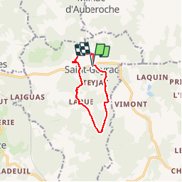
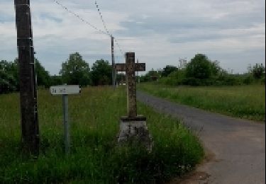
Trail Walking of 8.9 km to be discovered at New Aquitaine, Dordogne, Saint-Geyrac. This trail is proposed by YV24.

Description

D'après tracé de Yannick
Boucle  au sud du village, en majorité sur sentiers et des pistes entre champs et forêt.


Elevation profile

Positioning

Country:
France
Region :
New Aquitaine
Department/Province :
Dordogne
Municipality :
Saint-Geyrac
Location:
Unknown
Start:(UTM)
335884 ; 4994890 (31T) N.

Trails nearby

Trail On foot Saint-Pierre-de-Chignac - Boucle du Lavoir - Photo
On foot
PRO

On foot

Easy
Saint-Pierre-de-Chignac, New Aquitaine, Dordogne, France
5.3 km | 7.1 km-effort
1h 37min
Yes
Trail On foot Saint-Pierre-de-Chignac - Boucle de la Chapelle - Photo
On foot
PRO

On foot

Easy
Saint-Pierre-de-Chignac, New Aquitaine, Dordogne, France
14.7 km | 18.7 km-effort
4h 14min
No
Trail On foot Saint-Crépin-d'Auberoche - Boucle de la Tuillère - Photo
On foot
PRO

On foot

Easy
(1)
Saint-Crépin-d'Auberoche, New Aquitaine, Dordogne, France
7.6 km | 9.5 km-effort
2h 9min
Yes
Trail On foot Saint-Crépin-d'Auberoche - Boucle de la Tuillère (Variante courte) - Photo
On foot
PRO

On foot

Easy
Saint-Crépin-d'Auberoche, New Aquitaine, Dordogne, France
5.2 km | 6.8 km-effort
1h 33min
Yes
Trail On foot Rouffignac-Saint-Cernin-de-Reilhac - Boucle des abîmes - Photo
On foot
CC.RIDER

On foot

Easy
Rouffignac-Saint-Cernin-de-Reilhac, New Aquitaine, Dordogne, France
9.2 km | 11.1 km-effort
2h 30min
Yes
Trail Walking Rouffignac-Saint-Cernin-de-Reilhac - Rouffignac - Dolmen Dou Cayre - Photo
Walking
jcc24

Walking

Very easy
Rouffignac-Saint-Cernin-de-Reilhac, New Aquitaine, Dordogne, France
2 km | 2.3 km-effort
23min
No
Trail Walking Saint-Geyrac - Boucle de la Forêt - Photo
Walking
CC.RIDER

Walking

Difficult
Saint-Geyrac, New Aquitaine, Dordogne, France
13.1 km | 16.6 km-effort
3h 46min
Yes
Trail Walking Rouffignac-Saint-Cernin-de-Reilhac - Rouffignac  - Photo
Walking
swp648

Walking

Easy
Rouffignac-Saint-Cernin-de-Reilhac, New Aquitaine, Dordogne, France
9.6 km | 11.5 km-effort
2h 21min
Yes
Trail Walking Rouffignac-Saint-Cernin-de-Reilhac - Rouffignac - Photo
Walking
perigord

Walking

Easy
Rouffignac-Saint-Cernin-de-Reilhac, New Aquitaine, Dordogne, France
18 km | 23 km-effort
3h 58min
No


Close
My subscriptions