![](/images/other/stat-length.png)
![Trail Walking Goldbach-Altenbach - Refuge SC Cernay - Photo](https://media.geolcdn.com/t/1900/400/6c093ea3-eefb-4b02-aa86-cdce02ea05d3.jpg&format=pjpeg&maxdim=2)
Refuge SC Cernay
helmut68
User
![Length](/images/other/stat-length.png)
Length
9.3 km
![Max alt](https://static1.geolcdn.com/siteimages/upload/files/1508320355ic_sort_altitude_max_24dp.png)
Max alt
1091 m
![Uphill gradient](https://static1.geolcdn.com/siteimages/upload/files/1508320355ic_sort_den_pos_24dp.png)
Uphill gradient
453 m
![Km-Effort](/images/other/stat-length.png)
Km-Effort
15.4 km
![Min alt](https://static1.geolcdn.com/siteimages/upload/files/1508320355ic_sort_altitude_min_24dp.png)
Min alt
817 m
![Downhill gradient](https://static1.geolcdn.com/siteimages/upload/files/1508320355ic_sort_den_neg_24dp.png)
Downhill gradient
485 m
![Boucle](https://static1.geolcdn.com/siteimages/upload/files/16400158638029165_repeat_loop_refresh_sync_direction_icon.png)
Boucle
No
Creation date :
2019-08-18 07:47:05.622
Updated on :
2019-08-19 21:16:23.557
![Walking](https://static1.geolcdn.com/sitytour/trail-icons/101.png)
3h29
Difficulty : Medium
![Scan this QR Code to open this trail in the SityTrail application](https://capi.geolives.com/qq0zvz2zws4bq2lad0pu/sitytour/trails/2176231/qr.png?size=200)
FREE GPS app for hiking
About
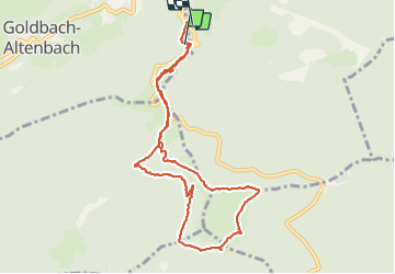
Trail Walking of 9.3 km to be discovered at Grand Est, Haut-Rhin, Goldbach-Altenbach. This trail is proposed by helmut68.
Description
Randonnée à partir du Col Amic pour rejoindre le refuge du SC Cernay près de l'auberge du Molkenrein. Belle boucle qui permet de voir la partie sud des Vosges et la forêt noir,ainsi que des vestiges de la grande Guerre...
Positioning
Country:
France
Region :
Grand Est
Department/Province :
Haut-Rhin
Municipality :
Goldbach-Altenbach
Location:
Unknown
Start:(Dec)
Start:(UTM)
359945 ; 5303900 (32T) N.
Comments
Trails nearby
![Trail Walking Soultz-Haut-Rhin - Hartmannswillerkopf - Circuit découverte - Photo](https://media.geolcdn.com/t/375/260/ext.jpg?maxdim=2&url=https%3A%2F%2Fservices.sitytrail.com%2FGeolivesWS%2FDownloadMedia.ashx%3FTrailID%3D422294%26Media%3Dfix__20150517124954.jpg)
![Walking Walking](https://static1.geolcdn.com/sitytour/trail-icons/101.png)
Hartmannswillerkopf - Circuit découverte
Walking
Easy
(1)
Soultz-Haut-Rhin,
Grand Est,
Haut-Rhin,
France
![](/images/other/stat-length.png)
3.6 km | 5.2 km-effort
1h 46min
![](https://static1.geolcdn.com/siteimages/upload/files/16400158638029165_repeat_loop_refresh_sync_direction_icon.png)
Yes
![Trail Walking Soultz-Haut-Rhin - Hartmannswillerkopf - Circuit anneau bleu - Photo](https://media.geolcdn.com/t/375/260/ext.jpg?maxdim=2&url=https%3A%2F%2Fservices.sitytrail.com%2FGeolivesWS%2FDownloadMedia.ashx%3FTrailID%3D422291%26Media%3Dfix__20150517150228.jpg)
![Walking Walking](https://static1.geolcdn.com/sitytour/trail-icons/101.png)
Hartmannswillerkopf - Circuit anneau bleu
Walking
Medium
(1)
Soultz-Haut-Rhin,
Grand Est,
Haut-Rhin,
France
![](/images/other/stat-length.png)
3.7 km | 5.9 km-effort
1h 37min
![](https://static1.geolcdn.com/siteimages/upload/files/16400158638029165_repeat_loop_refresh_sync_direction_icon.png)
Yes
![Trail Other activity Steinbach - lac du ballon - Photo](https://media.geolcdn.com/t/375/260/ext.jpg?maxdim=2&url=https%3A%2F%2Fservices.sitytrail.com%2FGeolivesWS%2FDownloadMedia.ashx%3FTrailID%3D210434%26Media%3Dfix__20130805111422.jpg)
![Other activity Other activity](https://static1.geolcdn.com/sitytour/trail-icons/900.png)
lac du ballon
Other activity
Very easy
(1)
Steinbach,
Grand Est,
Haut-Rhin,
France
![](/images/other/stat-length.png)
33 km | 64 km-effort
5h 1min
![](https://static1.geolcdn.com/siteimages/upload/files/16400158638029165_repeat_loop_refresh_sync_direction_icon.png)
No
![Trail On foot Goldbach-Altenbach - Firstacker - Willer sur Thur - Photo](https://media.geolcdn.com/t/375/260/203caa2b-07d7-4c6d-9f37-990a5db6b7c9.jpeg&format=jpg&maxdim=2)
![On foot On foot](https://static1.geolcdn.com/sitytour/trail-icons/100.png)
Firstacker - Willer sur Thur
On foot
Easy
Goldbach-Altenbach,
Grand Est,
Haut-Rhin,
France
![](/images/other/stat-length.png)
7.4 km | 9.6 km-effort
2h 11min
![](https://static1.geolcdn.com/siteimages/upload/files/16400158638029165_repeat_loop_refresh_sync_direction_icon.png)
No
![Trail Trail Wattwiller - The History Ultra - stage 1 - Photo](https://media.geolcdn.com/t/375/260/ext.jpg?maxdim=2&url=https%3A%2F%2Fstatic1.geolcdn.com%2Fsiteimages%2Fupload%2Ffiles%2F1524743154running.jpg)
![Trail Trail](https://static1.geolcdn.com/sitytour/trail-icons/104.png)
The History Ultra - stage 1
Trail
Very easy
(1)
Wattwiller,
Grand Est,
Haut-Rhin,
France
![](/images/other/stat-length.png)
28 km | 48 km-effort
Unknown
![](https://static1.geolcdn.com/siteimages/upload/files/16400158638029165_repeat_loop_refresh_sync_direction_icon.png)
No
![Trail On foot Bitschwiller-lès-Thann - Bitschwiller les Thann - Rehbrunnel - Abri du Becherkopf - Roche Albert - Photo](https://media.geolcdn.com/t/375/260/ext.jpg?maxdim=2&url=https%3A%2F%2Fstatic1.geolcdn.com%2Fsiteimages%2Fupload%2Ffiles%2F1545311037marcheuse_200dpi.jpg)
![On foot On foot](https://static1.geolcdn.com/sitytour/trail-icons/100.png)
Bitschwiller les Thann - Rehbrunnel - Abri du Becherkopf - Roche Albert
On foot
Medium
(1)
Bitschwiller-lès-Thann,
Grand Est,
Haut-Rhin,
France
![](/images/other/stat-length.png)
10.3 km | 16.4 km-effort
Unknown
![](https://static1.geolcdn.com/siteimages/upload/files/16400158638029165_repeat_loop_refresh_sync_direction_icon.png)
Yes
![Trail Walking Soultz-Haut-Rhin - Rando Marcheurs..04/04_2025 - Photo](https://media.geolcdn.com/t/375/260/2ab5dad5-2554-412a-abd7-9d4222ed2a04.jpg&format=jpg&maxdim=2)
![Walking Walking](https://static1.geolcdn.com/sitytour/trail-icons/101.png)
Rando Marcheurs..04/04_2025
Walking
Very difficult
Soultz-Haut-Rhin,
Grand Est,
Haut-Rhin,
France
![](/images/other/stat-length.png)
21 km | 35 km-effort
4h 42min
![](https://static1.geolcdn.com/siteimages/upload/files/16400158638029165_repeat_loop_refresh_sync_direction_icon.png)
Yes
![Trail Walking Jungholtz - Rando Retrouvailles...01/03/2024.par Jean Marc - Photo](https://media.geolcdn.com/t/375/260/a9ee6325-7504-4fd2-a0fe-1e1c5b8164cc.jpg&format=jpg&maxdim=2)
![Walking Walking](https://static1.geolcdn.com/sitytour/trail-icons/101.png)
Rando Retrouvailles...01/03/2024.par Jean Marc
Walking
Very difficult
Jungholtz,
Grand Est,
Haut-Rhin,
France
![](/images/other/stat-length.png)
11.3 km | 19.2 km-effort
1h 35min
![](https://static1.geolcdn.com/siteimages/upload/files/16400158638029165_repeat_loop_refresh_sync_direction_icon.png)
Yes
![Walking Walking](https://static1.geolcdn.com/sitytour/trail-icons/101.png)
Mon tour des Vosges (4 jours)
Walking
Very difficult
Soultz-Haut-Rhin,
Grand Est,
Haut-Rhin,
France
![](/images/other/stat-length.png)
71 km | 113 km-effort
25h 38min
![](https://static1.geolcdn.com/siteimages/upload/files/16400158638029165_repeat_loop_refresh_sync_direction_icon.png)
Yes