![](/images/other/stat-length.png)
![Trail Walking Hellenthal - Udenbreth- Rocherath - Photo](https://media.geolcdn.com/t/1900/400/ext.pjpeg?maxdim=2&url=https%3A%2F%2Fstatic1.geolcdn.com%2Fsiteimages%2Fupload%2Ffiles%2F1553511878bg_sport_marche.png)
Udenbreth- Rocherath
flip96
User
![Length](/images/other/stat-length.png)
Length
31 km
![Max alt](https://static1.geolcdn.com/siteimages/upload/files/1508320355ic_sort_altitude_max_24dp.png)
Max alt
703 m
![Uphill gradient](https://static1.geolcdn.com/siteimages/upload/files/1508320355ic_sort_den_pos_24dp.png)
Uphill gradient
544 m
![Km-Effort](/images/other/stat-length.png)
Km-Effort
38 km
![Min alt](https://static1.geolcdn.com/siteimages/upload/files/1508320355ic_sort_altitude_min_24dp.png)
Min alt
557 m
![Downhill gradient](https://static1.geolcdn.com/siteimages/upload/files/1508320355ic_sort_den_neg_24dp.png)
Downhill gradient
544 m
![Boucle](https://static1.geolcdn.com/siteimages/upload/files/16400158638029165_repeat_loop_refresh_sync_direction_icon.png)
Boucle
Yes
Creation date :
2014-12-10 00:00:00.0
Updated on :
2014-12-10 00:00:00.0
![Walking](https://static1.geolcdn.com/sitytour/trail-icons/101.png)
6h40
Difficulty : Medium
![Scan this QR Code to open this trail in the SityTrail application](https://capi.geolives.com/qq0zvz2zws4bq2lad0pu/sitytour/trails/217508/qr.png?size=200)
FREE GPS app for hiking
About
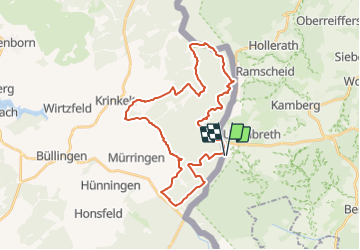
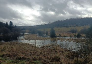
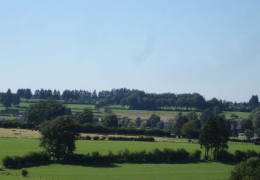
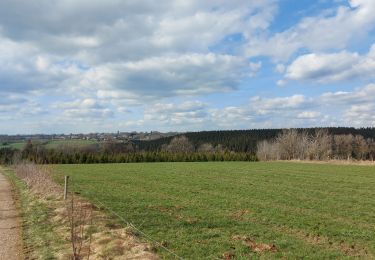
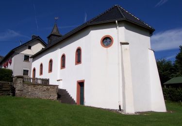
Trail Walking of 31 km to be discovered at North Rhine-Westphalia, Kreis Euskirchen, Hellenthal. This trail is proposed by flip96.
Description
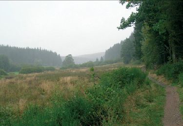
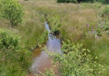
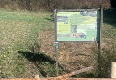
Rondwandeling vanaf Am Weisser Stein, aan de Duits-Belgische grens bij Udenbreth.
Mooie, eenvoudige wandeling.
Vanwege de lengte een medium moeilijkheid.
Opmerkingen? flip96@home.nl
Positioning
Country:
Germany
Region :
North Rhine-Westphalia
Department/Province :
Kreis Euskirchen
Municipality :
Hellenthal
Location:
Unknown
Start:(Dec)
Start:(UTM)
313190 ; 5587253 (32U) N.
Comments
Trails nearby
![Trail Walking Büllingen - RB-LG-07 - Entre Warche et Holzwarche - Photo](https://media.geolcdn.com/t/375/260/ext.jpg?maxdim=2&url=https%3A%2F%2Fservices.sitytrail.com%2FGeolivesWS%2FDownloadMedia.ashx%3FTrailID%3D179565%26Media%3Dc51bfdfa-2f3a-47fc-b12d-6def8be3ad34.jpg)
![Walking Walking](https://static1.geolcdn.com/sitytour/trail-icons/101.png)
RB-LG-07 - Entre Warche et Holzwarche
Walking
Medium
(7)
Büllingen,
Wallonia,
Liège,
Belgium
![](/images/other/stat-length.png)
21 km | 26 km-effort
5h 33min
![](https://static1.geolcdn.com/siteimages/upload/files/16400158638029165_repeat_loop_refresh_sync_direction_icon.png)
Yes
![Trail Walking Büllingen - Mürringen - Circuit Natura 2000, des sites qui valent le détour - Lg10 - Photo](https://media.geolcdn.com/t/375/260/ext.jpg?maxdim=2&url=https%3A%2F%2Fservices.sitytrail.com%2FGeolivesWS%2FDownloadMedia.ashx%3FTrailID%3D181911%26Media%3Dd1ada83f-52ce-4c18-b96f-8cdb6dcdeefb.jpg)
![Walking Walking](https://static1.geolcdn.com/sitytour/trail-icons/101.png)
Mürringen - Circuit Natura 2000, des sites qui valent le détour - Lg10
Walking
Easy
(3)
Büllingen,
Wallonia,
Liège,
Belgium
![](/images/other/stat-length.png)
7.1 km | 8.7 km-effort
1h 50min
![](https://static1.geolcdn.com/siteimages/upload/files/16400158638029165_repeat_loop_refresh_sync_direction_icon.png)
Yes
![Trail On foot Büllingen - Balade des Jonquilles Krinkelt 12 Km - Photo](https://media.geolcdn.com/t/375/260/634345eb-5787-4f3c-9ced-f45f24f65838.jpg&format=jpg&maxdim=2)
![On foot On foot](https://static1.geolcdn.com/sitytour/trail-icons/100.png)
Balade des Jonquilles Krinkelt 12 Km
On foot
Easy
Büllingen,
Wallonia,
Liège,
Belgium
![](/images/other/stat-length.png)
12 km | 14.3 km-effort
3h 14min
![](https://static1.geolcdn.com/siteimages/upload/files/16400158638029165_repeat_loop_refresh_sync_direction_icon.png)
Yes
![Trail Walking Büllingen - Rocherath - Photo](https://media.geolcdn.com/t/375/260/9865e976-42a9-4272-b5a8-4a981efc6f01.jpg&format=jpg&maxdim=2)
![Walking Walking](https://static1.geolcdn.com/sitytour/trail-icons/101.png)
![Trail On foot Büllingen - GrWandArd 15 Büchholz de pracht van het NP Eifel - Photo](https://media.geolcdn.com/t/375/260/0ae2ff0c-760f-408b-9aeb-c9e415472963.jpg&format=jpg&maxdim=2)
![On foot On foot](https://static1.geolcdn.com/sitytour/trail-icons/100.png)
GrWandArd 15 Büchholz de pracht van het NP Eifel
On foot
Easy
Büllingen,
Wallonia,
Liège,
Belgium
![](/images/other/stat-length.png)
9.9 km | 11.7 km-effort
2h 40min
![](https://static1.geolcdn.com/siteimages/upload/files/16400158638029165_repeat_loop_refresh_sync_direction_icon.png)
Yes
![Trail Walking Büllingen - Enkelbergermühle - Photo](https://media.geolcdn.com/t/375/260/3d7866fb-ce22-48f1-ac64-4b561fccb9aa.jpg&format=jpg&maxdim=2)
![Walking Walking](https://static1.geolcdn.com/sitytour/trail-icons/101.png)
Enkelbergermühle
Walking
Medium
Büllingen,
Wallonia,
Liège,
Belgium
![](/images/other/stat-length.png)
5.2 km | 6.3 km-effort
1h 28min
![](https://static1.geolcdn.com/siteimages/upload/files/16400158638029165_repeat_loop_refresh_sync_direction_icon.png)
Yes
![Trail On foot Hellenthal - Gebirgsstelzen- und Schwarzstorchpfad - Photo](https://media.geolcdn.com/t/375/260/b68bed5a-5dcd-4e0f-979f-12656b5ce086.jpeg&format=jpg&maxdim=2)
![On foot On foot](https://static1.geolcdn.com/sitytour/trail-icons/100.png)
Gebirgsstelzen- und Schwarzstorchpfad
On foot
Easy
Hellenthal,
North Rhine-Westphalia,
Kreis Euskirchen,
Germany
![](/images/other/stat-length.png)
12.7 km | 15.2 km-effort
3h 26min
![](https://static1.geolcdn.com/siteimages/upload/files/16400158638029165_repeat_loop_refresh_sync_direction_icon.png)
Yes
![Trail On foot Büllingen - Vallée de la Holzwarche - Photo](https://media.geolcdn.com/t/375/260/65d6ef04-b201-4cb3-a967-1a9fa6c005a5.jpeg&format=jpg&maxdim=2)
![On foot On foot](https://static1.geolcdn.com/sitytour/trail-icons/100.png)
Vallée de la Holzwarche
On foot
Easy
(2)
Büllingen,
Wallonia,
Liège,
Belgium
![](/images/other/stat-length.png)
9.6 km | 11.3 km-effort
2h 33min
![](https://static1.geolcdn.com/siteimages/upload/files/16400158638029165_repeat_loop_refresh_sync_direction_icon.png)
Yes
![Trail Walking Büllingen - La vallée de la Holzwarche - balade.be - Photo](https://media.geolcdn.com/t/375/260/ext.jpg?maxdim=2&url=https%3A%2F%2Fstatic1.geolcdn.com%2Fsiteimages%2Fupload%2Ffiles%2F1553511878bg_sport_marche.png)
![Walking Walking](https://static1.geolcdn.com/sitytour/trail-icons/101.png)
La vallée de la Holzwarche - balade.be
Walking
Medium
(1)
Büllingen,
Wallonia,
Liège,
Belgium
![](/images/other/stat-length.png)
9.8 km | 11.4 km-effort
2h 36min
![](https://static1.geolcdn.com/siteimages/upload/files/16400158638029165_repeat_loop_refresh_sync_direction_icon.png)
Yes