![](/images/other/stat-length.png)
![Trail Walking Soultz-Haut-Rhin - Col Amic Molkenrein - Photo](https://media.geolcdn.com/t/1900/400/f6232de5-90a9-4d8d-8b5c-58c109fe8e3f.jpg&format=pjpeg&maxdim=2)
Col Amic Molkenrein
helmut68
User
![Length](/images/other/stat-length.png)
Length
9.6 km
![Max alt](https://static1.geolcdn.com/siteimages/upload/files/1508320355ic_sort_altitude_max_24dp.png)
Max alt
1089 m
![Uphill gradient](https://static1.geolcdn.com/siteimages/upload/files/1508320355ic_sort_den_pos_24dp.png)
Uphill gradient
457 m
![Km-Effort](/images/other/stat-length.png)
Km-Effort
15.6 km
![Min alt](https://static1.geolcdn.com/siteimages/upload/files/1508320355ic_sort_altitude_min_24dp.png)
Min alt
824 m
![Downhill gradient](https://static1.geolcdn.com/siteimages/upload/files/1508320355ic_sort_den_neg_24dp.png)
Downhill gradient
456 m
![Boucle](https://static1.geolcdn.com/siteimages/upload/files/16400158638029165_repeat_loop_refresh_sync_direction_icon.png)
Boucle
Yes
Creation date :
2019-08-14 08:47:30.115
Updated on :
2019-08-17 17:22:31.454
![Walking](https://static1.geolcdn.com/sitytour/trail-icons/101.png)
3h48
Difficulty : Very easy
![Scan this QR Code to open this trail in the SityTrail application](https://capi.geolives.com/qq0zvz2zws4bq2lad0pu/sitytour/trails/2174352/qr.png?size=200)
FREE GPS app for hiking
About
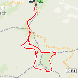
Trail Walking of 9.6 km to be discovered at Grand Est, Haut-Rhin, Soultz-Haut-Rhin. This trail is proposed by helmut68.
Description
Belle randonnée qui permet de voir le Thannerhubel,le Rossberg,l'auberge du Gsang,du Belaker et le grand Ballon
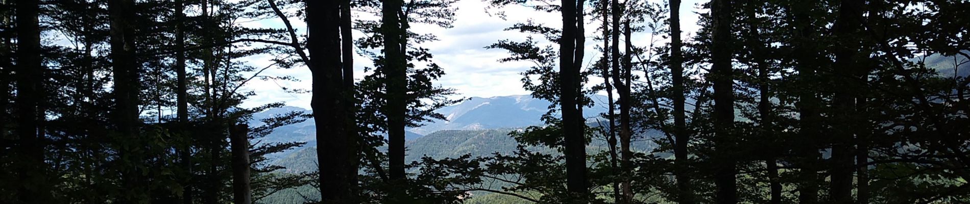
Une fois au Molkenrein vous avez un panorama sur la plaine d'Alsace.
Tout le long des vestiges de la grande guerre sont encore présents...
Positioning
Country:
France
Region :
Grand Est
Department/Province :
Haut-Rhin
Municipality :
Soultz-Haut-Rhin
Location:
Unknown
Start:(Dec)
Start:(UTM)
359988 ; 5304133 (32T) N.
Comments
Trails nearby
![Trail Walking Soultz-Haut-Rhin - Hartmannswillerkopf - Circuit découverte - Photo](https://media.geolcdn.com/t/375/260/ext.jpg?maxdim=2&url=https%3A%2F%2Fservices.sitytrail.com%2FGeolivesWS%2FDownloadMedia.ashx%3FTrailID%3D422294%26Media%3Dfix__20150517124954.jpg)
![Walking Walking](https://static1.geolcdn.com/sitytour/trail-icons/101.png)
Hartmannswillerkopf - Circuit découverte
Walking
Easy
(1)
Soultz-Haut-Rhin,
Grand Est,
Haut-Rhin,
France
![](/images/other/stat-length.png)
3.6 km | 5.2 km-effort
1h 46min
![](https://static1.geolcdn.com/siteimages/upload/files/16400158638029165_repeat_loop_refresh_sync_direction_icon.png)
Yes
![Trail Walking Soultz-Haut-Rhin - Hartmannswillerkopf - Circuit anneau bleu - Photo](https://media.geolcdn.com/t/375/260/ext.jpg?maxdim=2&url=https%3A%2F%2Fservices.sitytrail.com%2FGeolivesWS%2FDownloadMedia.ashx%3FTrailID%3D422291%26Media%3Dfix__20150517150228.jpg)
![Walking Walking](https://static1.geolcdn.com/sitytour/trail-icons/101.png)
Hartmannswillerkopf - Circuit anneau bleu
Walking
Medium
(1)
Soultz-Haut-Rhin,
Grand Est,
Haut-Rhin,
France
![](/images/other/stat-length.png)
3.7 km | 5.9 km-effort
1h 37min
![](https://static1.geolcdn.com/siteimages/upload/files/16400158638029165_repeat_loop_refresh_sync_direction_icon.png)
Yes
![Trail On foot Goldbach-Altenbach - Firstacker - Willer sur Thur - Photo](https://media.geolcdn.com/t/375/260/203caa2b-07d7-4c6d-9f37-990a5db6b7c9.jpeg&format=jpg&maxdim=2)
![On foot On foot](https://static1.geolcdn.com/sitytour/trail-icons/100.png)
Firstacker - Willer sur Thur
On foot
Easy
Goldbach-Altenbach,
Grand Est,
Haut-Rhin,
France
![](/images/other/stat-length.png)
7.4 km | 9.6 km-effort
2h 11min
![](https://static1.geolcdn.com/siteimages/upload/files/16400158638029165_repeat_loop_refresh_sync_direction_icon.png)
No
![Trail Trail Wattwiller - The History Ultra - stage 1 - Photo](https://media.geolcdn.com/t/375/260/ext.jpg?maxdim=2&url=https%3A%2F%2Fstatic1.geolcdn.com%2Fsiteimages%2Fupload%2Ffiles%2F1524743154running.jpg)
![Trail Trail](https://static1.geolcdn.com/sitytour/trail-icons/104.png)
The History Ultra - stage 1
Trail
Very easy
(1)
Wattwiller,
Grand Est,
Haut-Rhin,
France
![](/images/other/stat-length.png)
28 km | 48 km-effort
Unknown
![](https://static1.geolcdn.com/siteimages/upload/files/16400158638029165_repeat_loop_refresh_sync_direction_icon.png)
No
![Trail On foot Bitschwiller-lès-Thann - Bitschwiller les Thann - Rehbrunnel - Abri du Becherkopf - Roche Albert - Photo](https://media.geolcdn.com/t/375/260/ext.jpg?maxdim=2&url=https%3A%2F%2Fstatic1.geolcdn.com%2Fsiteimages%2Fupload%2Ffiles%2F1545311037marcheuse_200dpi.jpg)
![On foot On foot](https://static1.geolcdn.com/sitytour/trail-icons/100.png)
Bitschwiller les Thann - Rehbrunnel - Abri du Becherkopf - Roche Albert
On foot
Medium
(1)
Bitschwiller-lès-Thann,
Grand Est,
Haut-Rhin,
France
![](/images/other/stat-length.png)
10.3 km | 16.4 km-effort
Unknown
![](https://static1.geolcdn.com/siteimages/upload/files/16400158638029165_repeat_loop_refresh_sync_direction_icon.png)
Yes
![Trail Walking Soultz-Haut-Rhin - Rando Marcheurs..04/04_2025 - Photo](https://media.geolcdn.com/t/375/260/2ab5dad5-2554-412a-abd7-9d4222ed2a04.jpg&format=jpg&maxdim=2)
![Walking Walking](https://static1.geolcdn.com/sitytour/trail-icons/101.png)
Rando Marcheurs..04/04_2025
Walking
Very difficult
Soultz-Haut-Rhin,
Grand Est,
Haut-Rhin,
France
![](/images/other/stat-length.png)
21 km | 35 km-effort
4h 42min
![](https://static1.geolcdn.com/siteimages/upload/files/16400158638029165_repeat_loop_refresh_sync_direction_icon.png)
Yes
![Trail Walking Jungholtz - Rando Retrouvailles...01/03/2024.par Jean Marc - Photo](https://media.geolcdn.com/t/375/260/a9ee6325-7504-4fd2-a0fe-1e1c5b8164cc.jpg&format=jpg&maxdim=2)
![Walking Walking](https://static1.geolcdn.com/sitytour/trail-icons/101.png)
Rando Retrouvailles...01/03/2024.par Jean Marc
Walking
Very difficult
Jungholtz,
Grand Est,
Haut-Rhin,
France
![](/images/other/stat-length.png)
11.3 km | 19.2 km-effort
1h 35min
![](https://static1.geolcdn.com/siteimages/upload/files/16400158638029165_repeat_loop_refresh_sync_direction_icon.png)
Yes
![Walking Walking](https://static1.geolcdn.com/sitytour/trail-icons/101.png)
Mon tour des Vosges (4 jours)
Walking
Very difficult
Soultz-Haut-Rhin,
Grand Est,
Haut-Rhin,
France
![](/images/other/stat-length.png)
71 km | 113 km-effort
25h 38min
![](https://static1.geolcdn.com/siteimages/upload/files/16400158638029165_repeat_loop_refresh_sync_direction_icon.png)
Yes
![Trail Walking Wattwiller - Wattwiller - Domaine du Hirtz (30/03/2023) - Photo](https://media.geolcdn.com/t/375/260/fba38f94-41c6-40ad-89c3-14f41fe23918.jpg&format=jpg&maxdim=2)
![Walking Walking](https://static1.geolcdn.com/sitytour/trail-icons/101.png)
Wattwiller - Domaine du Hirtz (30/03/2023)
Walking
Easy
Wattwiller,
Grand Est,
Haut-Rhin,
France
![](/images/other/stat-length.png)
6.1 km | 9.9 km-effort
2h 7min
![](https://static1.geolcdn.com/siteimages/upload/files/16400158638029165_repeat_loop_refresh_sync_direction_icon.png)
Yes