![](/images/other/stat-length.png)
![Trail Nordic walking Sercus - Circuit Saint-Erasme - Photo](https://media.geolcdn.com/t/1900/400/ext.pjpeg?maxdim=2&url=https%3A%2F%2Fstatic1.geolcdn.com%2Fsiteimages%2Fupload%2Ffiles%2F1545311037marcheuse_200dpi.jpg)
Circuit Saint-Erasme
denissculier
User
![Length](/images/other/stat-length.png)
Length
7.8 km
![Max alt](https://static1.geolcdn.com/siteimages/upload/files/1508320355ic_sort_altitude_max_24dp.png)
Max alt
70 m
![Uphill gradient](https://static1.geolcdn.com/siteimages/upload/files/1508320355ic_sort_den_pos_24dp.png)
Uphill gradient
50 m
![Km-Effort](/images/other/stat-length.png)
Km-Effort
8.4 km
![Min alt](https://static1.geolcdn.com/siteimages/upload/files/1508320355ic_sort_altitude_min_24dp.png)
Min alt
47 m
![Downhill gradient](https://static1.geolcdn.com/siteimages/upload/files/1508320355ic_sort_den_neg_24dp.png)
Downhill gradient
49 m
![Boucle](https://static1.geolcdn.com/siteimages/upload/files/16400158638029165_repeat_loop_refresh_sync_direction_icon.png)
Boucle
Yes
Creation date :
2019-08-14 17:22:26.962
Updated on :
2019-08-14 17:28:21.141
![Nordic walking](https://static1.geolcdn.com/sitytour/trail-icons/102.png)
2h00
Difficulty : Medium
![Scan this QR Code to open this trail in the SityTrail application](https://capi.geolives.com/qq0zvz2zws4bq2lad0pu/sitytour/trails/2170872/qr.png?size=200)
FREE GPS app for hiking
About
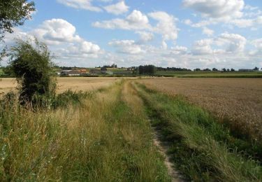
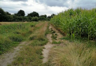
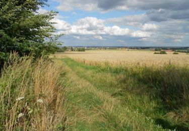
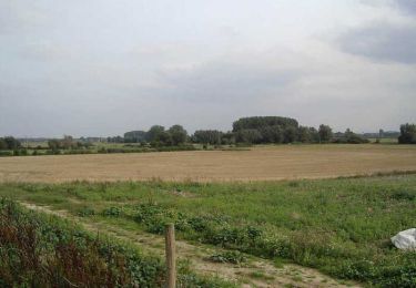
Trail Nordic walking of 7.8 km to be discovered at Hauts-de-France, Nord, Sercus. This trail is proposed by denissculier.
Description
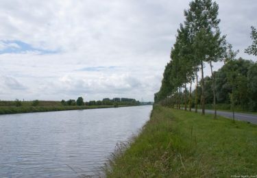
Ce circuit vallonné, à pratiquer toute l’année, est sans difficulté et conviendra à un public familial. Prudence toutefois en traversant la RD 238. En période de pluie, le port de chaussures étanches s’avère nécessaire sur les chemins agricoles.
Positioning
Country:
France
Region :
Hauts-de-France
Department/Province :
Nord
Municipality :
Sercus
Location:
Unknown
Start:(Dec)
Start:(UTM)
461400 ; 5617027 (31U) N.
Comments
Trails nearby
![Trail Walking Morbecque - Sentier des 3 bois (11,5 Km) - Morbecque - Photo](https://media.geolcdn.com/t/375/260/ext.jpg?maxdim=2&url=https%3A%2F%2Fservices.sitytrail.com%2FGeolivesWS%2FDownloadMedia.ashx%3FTrailID%3D215245%26Media%3D15869_5.jpg)
![Walking Walking](https://static1.geolcdn.com/sitytour/trail-icons/101.png)
Sentier des 3 bois (11,5 Km) - Morbecque
Walking
Medium
(1)
Morbecque,
Hauts-de-France,
Nord,
France
![](/images/other/stat-length.png)
11.5 km | 13.4 km-effort
3h 0min
![](https://static1.geolcdn.com/siteimages/upload/files/16400158638029165_repeat_loop_refresh_sync_direction_icon.png)
Yes
![Trail Trail Hazebrouck - 12 km Hazebrouck nature - Photo](https://media.geolcdn.com/t/375/260/829fb378-5591-4b49-ad45-adafc83404c4.jpg&format=jpg&maxdim=2)
![Trail Trail](https://static1.geolcdn.com/sitytour/trail-icons/104.png)
12 km Hazebrouck nature
Trail
Very easy
Hazebrouck,
Hauts-de-France,
Nord,
France
![](/images/other/stat-length.png)
12.1 km | 13 km-effort
1h 56min
![](https://static1.geolcdn.com/siteimages/upload/files/16400158638029165_repeat_loop_refresh_sync_direction_icon.png)
Yes
![Trail Cycle Morbecque - Le circuit des Oratoires - Morbecque - Photo](https://media.geolcdn.com/t/375/260/ext.jpg?maxdim=2&url=https%3A%2F%2Fservices.sitytrail.com%2FGeolivesWS%2FDownloadMedia.ashx%3FTrailID%3D215247%26Media%3D15871_6.jpg)
![Cycle Cycle](https://static1.geolcdn.com/sitytour/trail-icons/200.png)
Le circuit des Oratoires - Morbecque
Cycle
Medium
Morbecque,
Hauts-de-France,
Nord,
France
![](/images/other/stat-length.png)
16.9 km | 18.9 km-effort
1h 30min
![](https://static1.geolcdn.com/siteimages/upload/files/16400158638029165_repeat_loop_refresh_sync_direction_icon.png)
Yes
![Trail Walking Morbecque - Sentier des 3 bois (14,5 Km) - Morbecque - Photo](https://media.geolcdn.com/t/375/260/ext.jpg?maxdim=2&url=https%3A%2F%2Fservices.sitytrail.com%2FGeolivesWS%2FDownloadMedia.ashx%3FTrailID%3D215244%26Media%3D15868_5.jpg)
![Walking Walking](https://static1.geolcdn.com/sitytour/trail-icons/101.png)
Sentier des 3 bois (14,5 Km) - Morbecque
Walking
Difficult
Morbecque,
Hauts-de-France,
Nord,
France
![](/images/other/stat-length.png)
14.6 km | 16.8 km-effort
3h 45min
![](https://static1.geolcdn.com/siteimages/upload/files/16400158638029165_repeat_loop_refresh_sync_direction_icon.png)
Yes
![Trail Walking Boëseghem - Circuit de la tête de Flandre (Boëseghem) - Photo](https://media.geolcdn.com/t/375/260/ext.jpg?maxdim=2&url=https%3A%2F%2Fservices.sitytrail.com%2FGeolivesWS%2FDownloadMedia.ashx%3FTrailID%3D109551%26Media%3D4132_6.jpg)
![Walking Walking](https://static1.geolcdn.com/sitytour/trail-icons/101.png)
Circuit de la tête de Flandre (Boëseghem)
Walking
Medium
(1)
Boëseghem,
Hauts-de-France,
Nord,
France
![](/images/other/stat-length.png)
11.6 km | 12.6 km-effort
2h 45min
![](https://static1.geolcdn.com/siteimages/upload/files/16400158638029165_repeat_loop_refresh_sync_direction_icon.png)
Yes
![Trail Walking Wittes - La Melde - Wittes - Photo](https://media.geolcdn.com/t/375/260/ext.jpg?maxdim=2&url=https%3A%2F%2Fservices.sitytrail.com%2FGeolivesWS%2FDownloadMedia.ashx%3FTrailID%3D104308%26Media%3D7536_4.jpg)
![Walking Walking](https://static1.geolcdn.com/sitytour/trail-icons/101.png)
La Melde - Wittes
Walking
Medium
Wittes,
Hauts-de-France,
Pas-de-Calais,
France
![](/images/other/stat-length.png)
9.4 km | 10.1 km-effort
2h 19min
![](https://static1.geolcdn.com/siteimages/upload/files/16400158638029165_repeat_loop_refresh_sync_direction_icon.png)
Yes
![Trail Walking Wallon-Cappel - le chemin des Prince - Photo](https://media.geolcdn.com/t/375/260/ext.jpg?maxdim=2&url=https%3A%2F%2Fservices.sitytrail.com%2FGeolivesWS%2FDownloadMedia.ashx%3FTrailID%3D742745%26Media%3Dfix__20170411155332.jpg)
![Walking Walking](https://static1.geolcdn.com/sitytour/trail-icons/101.png)
le chemin des Prince
Walking
Very easy
Wallon-Cappel,
Hauts-de-France,
Nord,
France
![](/images/other/stat-length.png)
8.4 km | 9.1 km-effort
2h 4min
![](https://static1.geolcdn.com/siteimages/upload/files/16400158638029165_repeat_loop_refresh_sync_direction_icon.png)
Yes
![Trail Walking Morbecque - Le sentier de mémoire - Morbecque - Photo](https://media.geolcdn.com/t/375/260/ext.jpg?maxdim=2&url=https%3A%2F%2Fservices.sitytrail.com%2FGeolivesWS%2FDownloadMedia.ashx%3FTrailID%3D215246%26Media%3D15870_5.jpg)
![Walking Walking](https://static1.geolcdn.com/sitytour/trail-icons/101.png)
Le sentier de mémoire - Morbecque
Walking
Easy
Morbecque,
Hauts-de-France,
Nord,
France
![](/images/other/stat-length.png)
2.3 km | 2.5 km-effort
1h 0min
![](https://static1.geolcdn.com/siteimages/upload/files/16400158638029165_repeat_loop_refresh_sync_direction_icon.png)
Yes
![Trail Running Hazebrouck - 12 km Course nature - Photo](https://media.geolcdn.com/t/375/260/ext.jpg?maxdim=2&url=https%3A%2F%2Fstatic1.geolcdn.com%2Fsiteimages%2Fupload%2Ffiles%2F1524743154running.jpg)
![Running Running](https://static1.geolcdn.com/sitytour/trail-icons/103.png)
12 km Course nature
Running
Very easy
(1)
Hazebrouck,
Hauts-de-France,
Nord,
France
![](/images/other/stat-length.png)
12.1 km | 13 km-effort
Unknown
![](https://static1.geolcdn.com/siteimages/upload/files/16400158638029165_repeat_loop_refresh_sync_direction_icon.png)
Yes