


parc Ucka

Arnaud Dejean
User
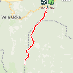

Length
7.3 km

Max alt
1385 m

Uphill gradient
451 m
Km-Effort
13.3 km

Min alt
926 m

Downhill gradient
457 m
Boucle
Yes
Creation date :
2019-08-13 04:35:30.682
Updated on :
2019-08-13 07:39:33.173
1h52
Difficulty : Medium

FREE GPS app for hiking
 SityTrail
IGN / Geographical institutes
SityTrail World
The world is yours!
About
Trail Walking of 7.3 km to be discovered at Unknown, Primorje-Gorski Kotar County. This trail is proposed by Arnaud Dejean.
Positioning
Country:
Croatia
Region :
Unknown
Department/Province :
Primorje-Gorski Kotar County
Municipality :
Unknown
Location:
Unknown
Start:(Dec)
Start:(UTM)
438486 ; 5017468 (33T) N.
Comments
Trails nearby