![](/images/other/stat-length.png)
![Trail Walking Durfort-et-Saint-Martin-de-Sossenac - 1.Entre Durfort et Fressac - Photo](https://media.geolcdn.com/t/1900/400/ext.pjpeg?maxdim=2&url=https%3A%2F%2Fstatic1.geolcdn.com%2Fsiteimages%2Fupload%2Ffiles%2F1553511878bg_sport_marche.png)
1.Entre Durfort et Fressac
randotines
User GUIDE
![Length](/images/other/stat-length.png)
Length
12.9 km
![Max alt](https://static1.geolcdn.com/siteimages/upload/files/1508320355ic_sort_altitude_max_24dp.png)
Max alt
339 m
![Uphill gradient](https://static1.geolcdn.com/siteimages/upload/files/1508320355ic_sort_den_pos_24dp.png)
Uphill gradient
382 m
![Km-Effort](/images/other/stat-length.png)
Km-Effort
18 km
![Min alt](https://static1.geolcdn.com/siteimages/upload/files/1508320355ic_sort_altitude_min_24dp.png)
Min alt
174 m
![Downhill gradient](https://static1.geolcdn.com/siteimages/upload/files/1508320355ic_sort_den_neg_24dp.png)
Downhill gradient
382 m
![Boucle](https://static1.geolcdn.com/siteimages/upload/files/16400158638029165_repeat_loop_refresh_sync_direction_icon.png)
Boucle
Yes
Creation date :
2015-01-29 00:00:00.0
Updated on :
2015-01-29 00:00:00.0
![Walking](https://static1.geolcdn.com/sitytour/trail-icons/101.png)
3h47
Difficulty : Medium
![Scan this QR Code to open this trail in the SityTrail application](https://capi.geolives.com/qq0zvz2zws4bq2lad0pu/sitytour/trails/216516/qr.png?size=200)
FREE GPS app for hiking
About
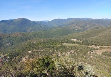
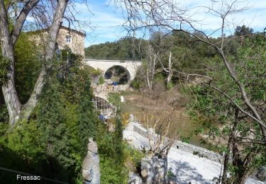
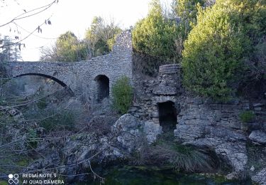
Trail Walking of 12.9 km to be discovered at Occitania, Gard, Durfort-et-Saint-Martin-de-Sossenac. This trail is proposed by randotines.
Description
14 km et 380 m de dénivelé. IGN Top 25 n°2741 ET ( St Hippolyte du fort - Anduze ). Départ au bas du village de Durfort.Visite des ruines du château de Fressac ( XIII ème siècle )
Positioning
Country:
France
Region :
Occitania
Department/Province :
Gard
Municipality :
Durfort-et-Saint-Martin-de-Sossenac
Location:
Unknown
Start:(Dec)
Start:(UTM)
576612 ; 4871103 (31T) N.
Comments
Trails nearby
![Trail Walking Sauve - Chateau de Freissac / le Crespou - Photo](https://media.geolcdn.com/t/375/260/7c638cf8-dd40-4fbf-83bf-0016c1c94c8e.jpg&format=jpg&maxdim=2)
![Walking Walking](https://static1.geolcdn.com/sitytour/trail-icons/101.png)
Chateau de Freissac / le Crespou
Walking
Medium
Sauve,
Occitania,
Gard,
France
![](/images/other/stat-length.png)
16.8 km | 23 km-effort
5h 40min
![](https://static1.geolcdn.com/siteimages/upload/files/16400158638029165_repeat_loop_refresh_sync_direction_icon.png)
Yes
![Trail Walking Durfort-et-Saint-Martin-de-Sossenac - circuit Durfort 2 - Photo](https://media.geolcdn.com/t/375/260/ext.jpg?maxdim=2&url=https%3A%2F%2Fstatic1.geolcdn.com%2Fsiteimages%2Fupload%2Ffiles%2F1553511878bg_sport_marche.png)
![Walking Walking](https://static1.geolcdn.com/sitytour/trail-icons/101.png)
circuit Durfort 2
Walking
Easy
(1)
Durfort-et-Saint-Martin-de-Sossenac,
Occitania,
Gard,
France
![](/images/other/stat-length.png)
8.1 km | 9.9 km-effort
2h 8min
![](https://static1.geolcdn.com/siteimages/upload/files/16400158638029165_repeat_loop_refresh_sync_direction_icon.png)
Yes
![Trail Walking Conqueyrac - les 2 jumelles près de St hippolythe - Photo](https://media.geolcdn.com/t/375/260/9cbcc03d-0a76-4d68-85e5-d108525f8703.jpg&format=jpg&maxdim=2)
![Walking Walking](https://static1.geolcdn.com/sitytour/trail-icons/101.png)
les 2 jumelles près de St hippolythe
Walking
Medium
Conqueyrac,
Occitania,
Gard,
France
![](/images/other/stat-length.png)
17.5 km | 25 km-effort
6h 3min
![](https://static1.geolcdn.com/siteimages/upload/files/16400158638029165_repeat_loop_refresh_sync_direction_icon.png)
Yes
![Trail Walking Sauve - Château Fressac - Sauve - Photo](https://media.geolcdn.com/t/375/260/ext.jpg?maxdim=2&url=https%3A%2F%2Fservices.sitytrail.com%2FGeolivesWS%2FDownloadMedia.ashx%3FTrailID%3D317692%26Media%3D16986_6.jpg)
![Walking Walking](https://static1.geolcdn.com/sitytour/trail-icons/101.png)
Château Fressac - Sauve
Walking
Difficult
Sauve,
Occitania,
Gard,
France
![](/images/other/stat-length.png)
16.3 km | 22 km-effort
6h 0min
![](https://static1.geolcdn.com/siteimages/upload/files/16400158638029165_repeat_loop_refresh_sync_direction_icon.png)
Yes
![Trail Cycle Monoblet - jmhugo - Photo](https://media.geolcdn.com/t/375/260/ext.jpg?maxdim=2&url=https%3A%2F%2Fservices.sitytrail.com%2FGeolivesWS%2FDownloadMedia.ashx%3FTrailID%3D146595%26Media%3D20120813172030.jpg)
![Cycle Cycle](https://static1.geolcdn.com/sitytour/trail-icons/200.png)
![Trail Walking Durfort-et-Saint-Martin-de-Sossenac - 30 Conturby et Ourne 21/01/24 - Photo](https://media.geolcdn.com/t/375/260/d89d8266-8b2e-43ea-8682-63ce4c3ccdd7.jpg&format=jpg&maxdim=2)
![Walking Walking](https://static1.geolcdn.com/sitytour/trail-icons/101.png)
30 Conturby et Ourne 21/01/24
Walking
Very difficult
Durfort-et-Saint-Martin-de-Sossenac,
Occitania,
Gard,
France
![](/images/other/stat-length.png)
17.6 km | 23 km-effort
5h 0min
![](https://static1.geolcdn.com/siteimages/upload/files/16400158638029165_repeat_loop_refresh_sync_direction_icon.png)
Yes
![Trail Walking Sauve - Crespenou et oppidum de Mus - Photo](https://media.geolcdn.com/t/375/260/ext.jpg?maxdim=2&url=https%3A%2F%2Fstatic1.geolcdn.com%2Fsiteimages%2Fupload%2Ffiles%2F1553511878bg_sport_marche.png)
![Walking Walking](https://static1.geolcdn.com/sitytour/trail-icons/101.png)
Crespenou et oppidum de Mus
Walking
Medium
Sauve,
Occitania,
Gard,
France
![](/images/other/stat-length.png)
6.3 km | 8.1 km-effort
1h 47min
![](https://static1.geolcdn.com/siteimages/upload/files/16400158638029165_repeat_loop_refresh_sync_direction_icon.png)
Yes
![Trail Walking Tornac - Le chemin des chasseurs -Tornac - Photo](https://media.geolcdn.com/t/375/260/ext.jpg?maxdim=2&url=https%3A%2F%2Fstatic1.geolcdn.com%2Fsiteimages%2Fupload%2Ffiles%2F1553511878bg_sport_marche.png)
![Walking Walking](https://static1.geolcdn.com/sitytour/trail-icons/101.png)
Le chemin des chasseurs -Tornac
Walking
Easy
Tornac,
Occitania,
Gard,
France
![](/images/other/stat-length.png)
14.8 km | 18.9 km-effort
5h 15min
![](https://static1.geolcdn.com/siteimages/upload/files/16400158638029165_repeat_loop_refresh_sync_direction_icon.png)
Yes
![Trail Walking Saint-Jean-de-Crieulon - Villesèque - Photo](https://media.geolcdn.com/t/375/260/ext.jpg?maxdim=2&url=https%3A%2F%2Fstatic1.geolcdn.com%2Fsiteimages%2Fupload%2Ffiles%2F1553511878bg_sport_marche.png)
![Walking Walking](https://static1.geolcdn.com/sitytour/trail-icons/101.png)
Villesèque
Walking
Easy
Saint-Jean-de-Crieulon,
Occitania,
Gard,
France
![](/images/other/stat-length.png)
15.7 km | 18.8 km-effort
4h 37min
![](https://static1.geolcdn.com/siteimages/upload/files/16400158638029165_repeat_loop_refresh_sync_direction_icon.png)
Yes