Trail Walking Orgnac-l'Aven - Orgnac combe d'oullins - Photo
 warnonjp
warnonjp

User

© OpenStreetMap contributors
Length
Length
15.3 km
Max alt
Max alt
395 m
Uphill gradient
Uphill gradient
524 m
Km-Effort
Km-Effort  
22 km
Min alt
Min alt
60 m
Downhill gradient
Downhill gradient
525 m
Boucle
Boucle
Yes
Creation date :
2019-08-07 12:29:16.119
Updated on :
2019-08-07 16:44:53.404

(1 Reviews)

Walking
Walking
4h14
Difficulty : Very easy

Scan this QR Code to open this trail in the SityTrail application

FREE GPS app for hiking

Logo SityTrail SityTrail

IGN / Geographical institutes

Download SityTrail from the App Store Download SityTrail from Google Play

Logo SityTrail SityTrail World

The world is yours!

Download SityTrail from the App Store Download SityTrail from Google Play Download SityTrail on Huawei AppGallery

About

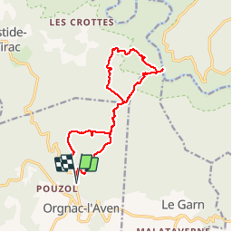
Trail Walking of 15.3 km to be discovered at Auvergne-Rhône-Alpes, Ardèche, Orgnac-l'Aven. This trail is proposed by warnonjp.

Description

descente sur l'Ardèche... Et remontée !

Elevation profile

Positioning

Country:
France
Region :
Auvergne-Rhône-Alpes
Department/Province :
Ardèche
Municipality :
Orgnac-l'Aven
Location:
Unknown
Start:(UTM)
614191 ; 4907569 (31T) N.

Comments

Please log in to post a review or rate the element


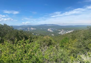
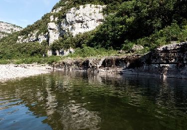
La partie gr4 est la moins intéressante (peu de points de vue intéressants).La descente sur l'Ardèche puis la remontée constituent l'essentiel du dénivelé (520m, quand même !). Mais la vue au bord de l'Ardèche récompense les efforts.


Trails nearby

Trail Walking Labastide-de-Virac - 07 gorges ardeche - Photo
Walking
GUIDE
randodyssée

Walking

Easy
(1)
Labastide-de-Virac, Auvergne-Rhône-Alpes, Ardèche, France
13.7 km | 22 km-effort
5h 5min
Yes
Trail Walking Saint-Remèze - Rapide de Gournier - Dolmen du Chanet - Photo
Walking
tracegps

Walking

Difficult
(3)
Saint-Remèze, Auvergne-Rhône-Alpes, Ardèche, France
5.9 km | 9.4 km-effort
2h 30min
Yes
Trail Walking Labastide-de-Virac - les gorges de l'Ardèche  - Photo
Walking
GUIDE
loca.yves

Walking

Medium
Labastide-de-Virac, Auvergne-Rhône-Alpes, Ardèche, France
8.9 km | 14.1 km-effort
5h 14min
Yes
Trail Walking Le Garn - le garn - Photo
Walking
losjo

Walking

Medium
(1)
Le Garn, Occitania, Gard, France
16.6 km | 25 km-effort
7h 54min
Yes
Trail Walking Saint-Remèze - St REMEZE, Grottes, gorges de l'Ardèche, dolmen du Chanet - Photo
Walking
poisson1103

Walking

Difficult
Saint-Remèze, Auvergne-Rhône-Alpes, Ardèche, France
8.1 km | 12.8 km-effort
2h 54min
Yes
Trail Walking Labastide-de-Virac - 2024-10-04_15h28m57_Du_hameau_des_Crottes_a_l_Ardeche - Photo
Walking
GUIDE
chancha

Walking

Very difficult
Labastide-de-Virac, Auvergne-Rhône-Alpes, Ardèche, France
13.6 km | 19.4 km-effort
4h 24min
Yes
Trail Walking Le Garn - Le Garn à l’Ardeche - Photo
Walking
GUIDE
Roger Philippe Wallez

Walking

Very difficult
Le Garn, Occitania, Gard, France
17.7 km | 26 km-effort
7h 4min
No
Trail Walking Labastide-de-Virac - les crottes - Photo
Walking
Vero7684

Walking

Medium
Labastide-de-Virac, Auvergne-Rhône-Alpes, Ardèche, France
12.2 km | 17.5 km-effort
4h 35min
Yes
Trail Walking Saint-Remèze - 2022-05-31_09h34m21_Dolmen du Chanet 9km.gpx.xml - Photo
Walking
GUIDE
chancha

Walking

Medium
Saint-Remèze, Auvergne-Rhône-Alpes, Ardèche, France
6.6 km | 10.1 km-effort
2h 17min
Yes


Close
My subscriptions