![](/images/other/stat-length.png)
![Trail Horseback riding Les Déserts - 2019 - La Féclaz / Pâturages - Photo](https://media.geolcdn.com/t/1900/400/ext.pjpeg?maxdim=2&url=https%3A%2F%2Fstatic1.geolcdn.com%2Fsiteimages%2Fupload%2Ffiles%2F1524743154cheval.jpg)
2019 - La Féclaz / Pâturages
Celine1217
User
![Length](/images/other/stat-length.png)
Length
23 km
![Max alt](https://static1.geolcdn.com/siteimages/upload/files/1508320355ic_sort_altitude_max_24dp.png)
Max alt
1405 m
![Uphill gradient](https://static1.geolcdn.com/siteimages/upload/files/1508320355ic_sort_den_pos_24dp.png)
Uphill gradient
555 m
![Km-Effort](/images/other/stat-length.png)
Km-Effort
30 km
![Min alt](https://static1.geolcdn.com/siteimages/upload/files/1508320355ic_sort_altitude_min_24dp.png)
Min alt
1130 m
![Downhill gradient](https://static1.geolcdn.com/siteimages/upload/files/1508320355ic_sort_den_neg_24dp.png)
Downhill gradient
555 m
![Boucle](https://static1.geolcdn.com/siteimages/upload/files/16400158638029165_repeat_loop_refresh_sync_direction_icon.png)
Boucle
Yes
Creation date :
2019-08-04 07:58:16.981
Updated on :
2019-08-05 06:31:10.555
![Horseback riding](https://static1.geolcdn.com/sitytour/trail-icons/301.png)
5h48
Difficulty : Medium
![Scan this QR Code to open this trail in the SityTrail application](https://capi.geolives.com/qq0zvz2zws4bq2lad0pu/sitytour/trails/2159793/qr.png?size=200)
FREE GPS app for hiking
About
Trail Horseback riding of 23 km to be discovered at Auvergne-Rhône-Alpes, Savoy, Les Déserts. This trail is proposed by Celine1217.
Description
Magnifique sortie d'une journée. Départ de l'hôtel Notre Dame des Neiges et grande boucle jusqu'aux pâturages. Itinéraire très varié. Env. 5 heures à cheval, avec pause pic-nic bienvenue après les pâturages.
Positioning
Country:
France
Region :
Auvergne-Rhône-Alpes
Department/Province :
Savoy
Municipality :
Les Déserts
Location:
Unknown
Start:(Dec)
Start:(UTM)
732688 ; 5058878 (31T) N.
Comments
Trails nearby
![Trail Walking Montcel - BAUGES: TOUR DE LA FORET DOMANIALE DU GRAND REVARD - Photo](https://media.geolcdn.com/t/375/260/2b01686d-4589-4bde-9389-487a67061fc0.jpg&format=jpg&maxdim=2)
![Walking Walking](https://static1.geolcdn.com/sitytour/trail-icons/101.png)
BAUGES: TOUR DE LA FORET DOMANIALE DU GRAND REVARD
Walking
Difficult
(1)
Montcel,
Auvergne-Rhône-Alpes,
Savoy,
France
![](/images/other/stat-length.png)
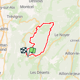
16.6 km | 24 km-effort
5h 15min
![](https://static1.geolcdn.com/siteimages/upload/files/16400158638029165_repeat_loop_refresh_sync_direction_icon.png)
Yes
![Trail Walking Les Déserts - golet de l'agneau - Photo](https://media.geolcdn.com/t/375/260/ext.jpg?maxdim=2&url=https%3A%2F%2Fservices.sitytrail.com%2FGeolivesWS%2FDownloadMedia.ashx%3FTrailID%3D229605%26Media%3Dfix__20131028144817.jpg)
![Walking Walking](https://static1.geolcdn.com/sitytour/trail-icons/101.png)
golet de l'agneau
Walking
Medium
(1)
Les Déserts,
Auvergne-Rhône-Alpes,
Savoy,
France
![](/images/other/stat-length.png)
3.9 km | 10.2 km-effort
1h 44min
![](https://static1.geolcdn.com/siteimages/upload/files/16400158638029165_repeat_loop_refresh_sync_direction_icon.png)
No
![Trail Walking Les Déserts - Circuit de la Croix Nivolet - Photo](https://media.geolcdn.com/t/375/260/ext.jpg?maxdim=2&url=https%3A%2F%2Fstatic1.geolcdn.com%2Fsiteimages%2Fupload%2Ffiles%2F1553511878bg_sport_marche.png)
![Walking Walking](https://static1.geolcdn.com/sitytour/trail-icons/101.png)
Circuit de la Croix Nivolet
Walking
Very easy
(1)
Les Déserts,
Auvergne-Rhône-Alpes,
Savoy,
France
![](/images/other/stat-length.png)
3.5 km | 5.6 km-effort
Unknown
![](https://static1.geolcdn.com/siteimages/upload/files/16400158638029165_repeat_loop_refresh_sync_direction_icon.png)
Yes
![Trail Walking Thoiry - le golet de l'agneau - Photo](https://media.geolcdn.com/t/375/260/95fcbe0f-c4e5-4eb2-ad04-6bb3c6835482.jpg&format=jpg&maxdim=2)
![Walking Walking](https://static1.geolcdn.com/sitytour/trail-icons/101.png)
le golet de l'agneau
Walking
Medium
Thoiry,
Auvergne-Rhône-Alpes,
Savoy,
France
![](/images/other/stat-length.png)
13.2 km | 26 km-effort
5h 20min
![](https://static1.geolcdn.com/siteimages/upload/files/16400158638029165_repeat_loop_refresh_sync_direction_icon.png)
Yes
![Trail Walking Montcel - BAUGES: PETIT TOUR DE LA FORET DOMANIALE DU REVARD - Photo](https://media.geolcdn.com/t/375/260/ext.jpg?maxdim=2&url=https%3A%2F%2Fstatic1.geolcdn.com%2Fsiteimages%2Fupload%2Ffiles%2F1553511878bg_sport_marche.png)
![Walking Walking](https://static1.geolcdn.com/sitytour/trail-icons/101.png)
BAUGES: PETIT TOUR DE LA FORET DOMANIALE DU REVARD
Walking
Medium
(1)
Montcel,
Auvergne-Rhône-Alpes,
Savoy,
France
![](/images/other/stat-length.png)
12.4 km | 17.2 km-effort
3h 30min
![](https://static1.geolcdn.com/siteimages/upload/files/16400158638029165_repeat_loop_refresh_sync_direction_icon.png)
Yes
![Trail Walking Mouxy - Sentier du Perthuiset - Photo](https://media.geolcdn.com/t/375/260/ext.jpg?maxdim=2&url=https%3A%2F%2Fstatic1.geolcdn.com%2Fsiteimages%2Fupload%2Ffiles%2F1553511878bg_sport_marche.png)
![Walking Walking](https://static1.geolcdn.com/sitytour/trail-icons/101.png)
Sentier du Perthuiset
Walking
Medium
(1)
Mouxy,
Auvergne-Rhône-Alpes,
Savoy,
France
![](/images/other/stat-length.png)
9.4 km | 19.9 km-effort
3h 19min
![](https://static1.geolcdn.com/siteimages/upload/files/16400158638029165_repeat_loop_refresh_sync_direction_icon.png)
Yes
![Trail Walking Les Déserts - Revard : La Féclaz - Photo](https://media.geolcdn.com/t/375/260/ext.jpg?maxdim=2&url=https%3A%2F%2Fstatic1.geolcdn.com%2Fsiteimages%2Fupload%2Ffiles%2F1553511878bg_sport_marche.png)
![Walking Walking](https://static1.geolcdn.com/sitytour/trail-icons/101.png)
Revard : La Féclaz
Walking
Easy
(1)
Les Déserts,
Auvergne-Rhône-Alpes,
Savoy,
France
![](/images/other/stat-length.png)
8.8 km | 10.6 km-effort
2h 22min
![](https://static1.geolcdn.com/siteimages/upload/files/16400158638029165_repeat_loop_refresh_sync_direction_icon.png)
Yes
![Trail Walking Montcel - La Culaz - Photo](https://media.geolcdn.com/t/375/260/6c40c4b5-435c-4557-a5f4-da8b6d9d2eb0.jpg&format=jpg&maxdim=2)
![Walking Walking](https://static1.geolcdn.com/sitytour/trail-icons/101.png)
La Culaz
Walking
Very difficult
Montcel,
Auvergne-Rhône-Alpes,
Savoy,
France
![](/images/other/stat-length.png)
15.7 km | 22 km-effort
6h 42min
![](https://static1.geolcdn.com/siteimages/upload/files/16400158638029165_repeat_loop_refresh_sync_direction_icon.png)
Yes
![Trail Walking Montcel - La Croix du Berger - Photo](https://media.geolcdn.com/t/375/260/f986dc09-993f-4c5c-ae42-1f703662732a.jpg&format=jpg&maxdim=2)
![Walking Walking](https://static1.geolcdn.com/sitytour/trail-icons/101.png)
La Croix du Berger
Walking
Medium
Montcel,
Auvergne-Rhône-Alpes,
Savoy,
France
![](/images/other/stat-length.png)
8.8 km | 11.7 km-effort
2h 39min
![](https://static1.geolcdn.com/siteimages/upload/files/16400158638029165_repeat_loop_refresh_sync_direction_icon.png)
Yes