![](/images/other/stat-length.png)
![Trail Walking Wissant - Wissant-Mont de Couple- retour par la plage - Photo](https://media.geolcdn.com/t/1900/400/6a90087b-5622-41da-a3b9-e42ff4ae0e92.jpg&format=pjpeg&maxdim=2)
Wissant-Mont de Couple- retour par la plage
© OpenStreetMap contributors
![Walking](https://static1.geolcdn.com/sitytour/trail-icons/101.png)
Walking
2h53
Difficulty : Difficult
![Length](/images/other/stat-length.png)
Length
14.3 km
![Boucle](https://static1.geolcdn.com/siteimages/upload/files/16400158638029165_repeat_loop_refresh_sync_direction_icon.png)
Boucle
Yes
Creation date :
2019-08-04 07:19:28.0
Updated on :
2019-08-04 10:15:58.533
![Walking](https://static1.geolcdn.com/sitytour/trail-icons/101.png)
2h53
Difficulty : Difficult
![Scan this QR Code to open this trail in the SityTrail application](https://capi.geolives.com/qq0zvz2zws4bq2lad0pu/sitytour/trails/2159537/qr.png?size=200)
FREE GPS app for hiking
About
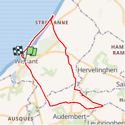
Trail Walking of 14.3 km to be discovered at Hauts-de-France, Pas-de-Calais, Wissant. This trail is proposed by Vagabond gaumardennais.
Description
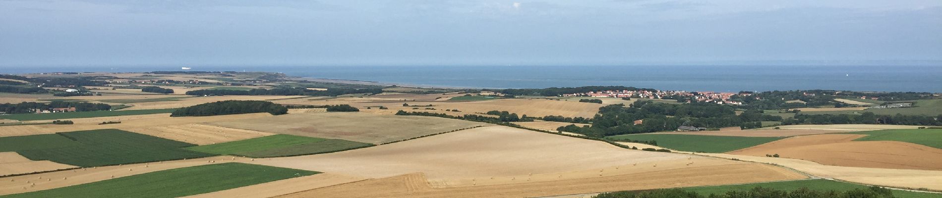
Parcours entre champs et culture jusqu’au point de vue exceptionnel à 360 sur la terre des 2 Caps. Un must pour celui où celle qui passe par Wissant
Positioning
Country:
France
Region :
Hauts-de-France
Department/Province :
Pas-de-Calais
Municipality :
Wissant
Location:
Unknown
Start:(Dec)
Start:(UTM)
405965 ; 5637928 (31U) N.
Comments
Trails nearby
![Trail Walking Wissant - Le Fartz - Photo](https://media.geolcdn.com/t/375/260/21ada877-513c-478a-b332-d0dc0a2aace8.jpg&format=jpg&maxdim=2)
![Walking Walking](https://static1.geolcdn.com/sitytour/trail-icons/101.png)
Le Fartz
Walking
Very easy
(1)
Wissant,
Hauts-de-France,
Pas-de-Calais,
France
![](/images/other/stat-length.png)
5.5 km | 6.2 km-effort
1h 29min
![](https://static1.geolcdn.com/siteimages/upload/files/16400158638029165_repeat_loop_refresh_sync_direction_icon.png)
Yes
![Trail Walking Escalles - Les balcons d'Escalles - Photo](https://media.geolcdn.com/t/375/260/ext.jpg?maxdim=2&url=https%3A%2F%2Fservices.sitytrail.com%2FGeolivesWS%2FDownloadMedia.ashx%3FTrailID%3D110282%26Media%3D5677_6.jpg)
![Walking Walking](https://static1.geolcdn.com/sitytour/trail-icons/101.png)
Les balcons d'Escalles
Walking
Medium
(5)
Escalles,
Hauts-de-France,
Pas-de-Calais,
France
![](/images/other/stat-length.png)
7.8 km | 10.5 km-effort
2h 0min
![](https://static1.geolcdn.com/siteimages/upload/files/16400158638029165_repeat_loop_refresh_sync_direction_icon.png)
Yes
![Trail Walking Sangatte - Le Site des 2 Caps - Les Falaises du Cap Blanc Nez et le Mont d'Hubert - Photo](https://media.geolcdn.com/t/375/260/ext.jpg?maxdim=2&url=https%3A%2F%2Fservices.sitytrail.com%2FGeolivesWS%2FDownloadMedia.ashx%3FTrailID%3D109468%26Media%3D4011_6.jpg)
![Walking Walking](https://static1.geolcdn.com/sitytour/trail-icons/101.png)
Le Site des 2 Caps - Les Falaises du Cap Blanc Nez et le Mont d'Hubert
Walking
Medium
(3)
Sangatte,
Hauts-de-France,
Pas-de-Calais,
France
![](/images/other/stat-length.png)
11.2 km | 14.7 km-effort
3h 0min
![](https://static1.geolcdn.com/siteimages/upload/files/16400158638029165_repeat_loop_refresh_sync_direction_icon.png)
Yes
![Trail Walking Tardinghen - Le Site des 2 Caps - Le Sentier des Crans - Photo](https://media.geolcdn.com/t/375/260/ext.jpg?maxdim=2&url=https%3A%2F%2Fservices.sitytrail.com%2FGeolivesWS%2FDownloadMedia.ashx%3FTrailID%3D109462%26Media%3D3985_6.jpg)
![Walking Walking](https://static1.geolcdn.com/sitytour/trail-icons/101.png)
Le Site des 2 Caps - Le Sentier des Crans
Walking
Medium
(2)
Tardinghen,
Hauts-de-France,
Pas-de-Calais,
France
![](/images/other/stat-length.png)
12 km | 14.3 km-effort
3h 0min
![](https://static1.geolcdn.com/siteimages/upload/files/16400158638029165_repeat_loop_refresh_sync_direction_icon.png)
Yes
![Trail Walking Tardinghen - Sentier du Fartz - Waissant - Photo](https://media.geolcdn.com/t/375/260/ext.jpg?maxdim=2&url=https%3A%2F%2Fservices.sitytrail.com%2FGeolivesWS%2FDownloadMedia.ashx%3FTrailID%3D106661%26Media%3D11281_6.jpg)
![Walking Walking](https://static1.geolcdn.com/sitytour/trail-icons/101.png)
Sentier du Fartz - Waissant
Walking
Easy
(1)
Tardinghen,
Hauts-de-France,
Pas-de-Calais,
France
![](/images/other/stat-length.png)
5.1 km | 5.8 km-effort
1h 30min
![](https://static1.geolcdn.com/siteimages/upload/files/16400158638029165_repeat_loop_refresh_sync_direction_icon.png)
Yes
![Trail Walking Tardinghen - Le Site des 2 Caps - Le Sentier des Crans - Photo](https://media.geolcdn.com/t/375/260/ext.jpg?maxdim=2&url=https%3A%2F%2Fstatic1.geolcdn.com%2Fsiteimages%2Fupload%2Ffiles%2F1553511878bg_sport_marche.png)
![Walking Walking](https://static1.geolcdn.com/sitytour/trail-icons/101.png)
Le Site des 2 Caps - Le Sentier des Crans
Walking
Easy
(3)
Tardinghen,
Hauts-de-France,
Pas-de-Calais,
France
![](/images/other/stat-length.png)
12 km | 14.3 km-effort
3h 0min
![](https://static1.geolcdn.com/siteimages/upload/files/16400158638029165_repeat_loop_refresh_sync_direction_icon.png)
Yes
![Trail Walking Wissant - Le Site des 2 Caps - Le Sentier du Phartz et de la Dune d'Aval - Photo](https://media.geolcdn.com/t/375/260/ext.jpg?maxdim=2&url=https%3A%2F%2Fstatic1.geolcdn.com%2Fsiteimages%2Fupload%2Ffiles%2F1553511878bg_sport_marche.png)
![Walking Walking](https://static1.geolcdn.com/sitytour/trail-icons/101.png)
Le Site des 2 Caps - Le Sentier du Phartz et de la Dune d'Aval
Walking
Easy
(3)
Wissant,
Hauts-de-France,
Pas-de-Calais,
France
![](/images/other/stat-length.png)
7.4 km | 8.3 km-effort
1h 50min
![](https://static1.geolcdn.com/siteimages/upload/files/16400158638029165_repeat_loop_refresh_sync_direction_icon.png)
Yes
![Trail Walking Sangatte - Le Site des 2 Caps - Les Falaises du Cap Blanc Nez et le Mont d'Hubert - Photo](https://media.geolcdn.com/t/375/260/ext.jpg?maxdim=2&url=https%3A%2F%2Fstatic1.geolcdn.com%2Fsiteimages%2Fupload%2Ffiles%2F1553511878bg_sport_marche.png)
![Walking Walking](https://static1.geolcdn.com/sitytour/trail-icons/101.png)
Le Site des 2 Caps - Les Falaises du Cap Blanc Nez et le Mont d'Hubert
Walking
Easy
(4)
Sangatte,
Hauts-de-France,
Pas-de-Calais,
France
![](/images/other/stat-length.png)
11.2 km | 14.7 km-effort
2h 50min
![](https://static1.geolcdn.com/siteimages/upload/files/16400158638029165_repeat_loop_refresh_sync_direction_icon.png)
Yes
![Trail Walking Wissant - 20240719 - TOTEMUS Wissant - 4.9 Km - Photo](https://media.geolcdn.com/t/375/260/7f9acced-e346-45f4-82d8-43ee0fccc265.jpg&format=jpg&maxdim=2)
![Walking Walking](https://static1.geolcdn.com/sitytour/trail-icons/101.png)
20240719 - TOTEMUS Wissant - 4.9 Km
Walking
Easy
(1)
Wissant,
Hauts-de-France,
Pas-de-Calais,
France
![](/images/other/stat-length.png)
4.9 km | 5.6 km-effort
2h 26min
![](https://static1.geolcdn.com/siteimages/upload/files/16400158638029165_repeat_loop_refresh_sync_direction_icon.png)
Yes
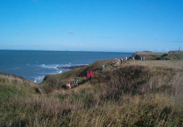
joli parcours entre terres et mer.