Trail Walking Gap - Le Huchon et pic de Charance - Photo

Le Huchon et pic de Charance

 gibello
gibello

User

© OpenStreetMap contributors
Length
Length
11.3 km
Boucle
Boucle
Yes
Creation date :
2019-08-04 06:10:47.517
Updated on :
2019-08-04 09:48:01.343

(1 Reviews)

Walking
Walking
3h35
Difficulty : Medium

Scan this QR Code to open this trail in the SityTrail application

FREE GPS app for hiking

Logo SityTrail SityTrail

IGN / Geographical institutes

Download SityTrail from the App Store Download SityTrail from Google Play

Logo SityTrail SityTrail World

The world is yours!

Download SityTrail from the App Store Download SityTrail from Google Play Download SityTrail on Huawei AppGallery

About

Trail Walking of 11.3 km to be discovered at Provence-Alpes-Côte d'Azur, Hautes-Alpes, Gap. This trail is proposed by gibello.

Description

départ des baretys..par les rougiers

Elevation profile

Photos

Positioning

Country:
France
Region :
Provence-Alpes-Côte d'Azur
Department/Province :
Hautes-Alpes
Municipality :
Gap
Location:
Gap
Start:(UTM)
263230 ; 4938389 (32T) N.

Comments

Please log in to post a review or rate the element


Trails nearby

Trail Walking Gap - Brèche et croix de Charance - Photo
Walking
GUIDE
R@ph

Walking

Easy
(1)
Gap, Provence-Alpes-Côte d'Azur, Hautes-Alpes, France
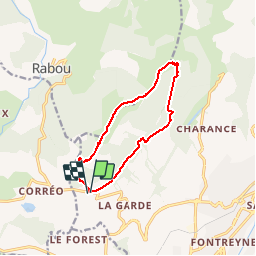
8.6 km | 18.5 km-effort
2h 13min
No
Trail Walking Rabou - Rabou Tour du Puy - Photo
Walking
GUIDE
Marco05

Walking

Medium
Rabou, Provence-Alpes-Côte d'Azur, Hautes-Alpes, France
11.5 km | 21 km-effort
4h 46min
Yes
Trail Walking Gap - Pic de Charance - Photo
Walking
GUIDE
Marco05

Walking

Medium
Gap, Provence-Alpes-Côte d'Azur, Hautes-Alpes, France
8.9 km | 19 km-effort
4h 18min
Yes
Trail Walking Rabou - Pic Melette - Photo
Walking
GUIDE
Marco05

Walking

Difficult
Rabou, Provence-Alpes-Côte d'Azur, Hautes-Alpes, France
9.8 km | 22 km-effort
4h 59min
Yes
Trail Walking Gap - Cuchon-Pic de Charance - Photo
Walking
GUIDE
Marco05

Walking

Difficult
Gap, Provence-Alpes-Côte d'Azur, Hautes-Alpes, France
12.3 km | 24 km-effort
5h 32min
Yes
Trail Walking Gap - Col de Guizière - Photo
Walking
GUIDE
Marco05

Walking

Medium
Gap, Provence-Alpes-Côte d'Azur, Hautes-Alpes, France
8.7 km | 17.5 km-effort
3h 58min
Yes
Trail Walking Gap - 7 Chemin GAP - LA MOTTE DU CAIRE - Photo
Walking
GUIDE
R@ph

Walking

Very difficult
Gap, Provence-Alpes-Côte d'Azur, Hautes-Alpes, France
41 km | 60 km-effort
11h 0min
No
Trail Mountain bike La Roche-des-Arnauds - La Rivière - Photo
Mountain bike
GUIDE+

Mountain bike

Difficult
La Roche-des-Arnauds, Provence-Alpes-Côte d'Azur, Hautes-Alpes, France
38 km | 54 km-effort
2h 31min
Yes
Trail On foot Rabou - 9587041 - Photo
On foot
GUIDE+

On foot

Easy
Rabou, Provence-Alpes-Côte d'Azur, Hautes-Alpes, France
6.6 km | 10.6 km-effort
3h 56min
No


Close
My subscriptions