![](/images/other/stat-length.png)
![Trail Mountain bike Mercin-et-Vaux - 02- Le sentier de Clovis - Photo](https://media.geolcdn.com/t/1900/400/ext.pjpeg?maxdim=2&url=https%3A%2F%2Fstatic1.geolcdn.com%2Fsiteimages%2Fupload%2Ffiles%2F1524743154velo.jpg)
02- Le sentier de Clovis
cavpsy74
User
![Length](/images/other/stat-length.png)
Length
28 km
![Max alt](https://static1.geolcdn.com/siteimages/upload/files/1508320355ic_sort_altitude_max_24dp.png)
Max alt
136 m
![Uphill gradient](https://static1.geolcdn.com/siteimages/upload/files/1508320355ic_sort_den_pos_24dp.png)
Uphill gradient
461 m
![Km-Effort](/images/other/stat-length.png)
Km-Effort
34 km
![Min alt](https://static1.geolcdn.com/siteimages/upload/files/1508320355ic_sort_altitude_min_24dp.png)
Min alt
38 m
![Downhill gradient](https://static1.geolcdn.com/siteimages/upload/files/1508320355ic_sort_den_neg_24dp.png)
Downhill gradient
461 m
![Boucle](https://static1.geolcdn.com/siteimages/upload/files/16400158638029165_repeat_loop_refresh_sync_direction_icon.png)
Boucle
Yes
Creation date :
2014-12-10 00:00:00.0
Updated on :
2014-12-10 00:00:00.0
![Mountain bike](https://static1.geolcdn.com/sitytour/trail-icons/202.png)
2h16
Difficulty : Easy
![Scan this QR Code to open this trail in the SityTrail application](https://capi.geolives.com/qq0zvz2zws4bq2lad0pu/sitytour/trails/215815/qr.png?size=200)
FREE GPS app for hiking
About
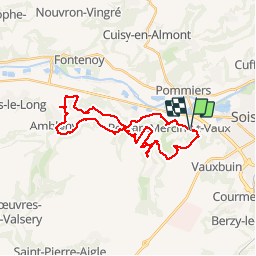
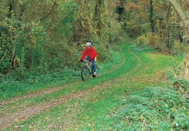
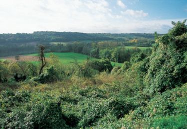
Trail Mountain bike of 28 km to be discovered at Hauts-de-France, Aisne, Mercin-et-Vaux. This trail is proposed by cavpsy74.
Description
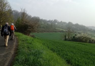
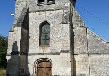
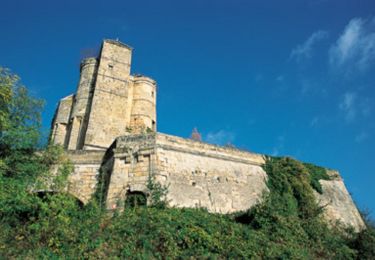
Au départ de Mercin-et-Vaux, une belle ballade entre blé et betterave, dans des chemins herbeux. Admirer au passage le donjon d'Ambleny.
Positioning
Country:
France
Region :
Hauts-de-France
Department/Province :
Aisne
Municipality :
Mercin-et-Vaux
Location:
Unknown
Start:(Dec)
Start:(UTM)
520090 ; 5469238 (31U) N.
Comments
Trails nearby
![Trail Walking Osly-Courtil - La balade de Saint-Médard - Photo](https://media.geolcdn.com/t/375/260/ext.jpg?maxdim=2&url=https%3A%2F%2Fservices.sitytrail.com%2FGeolivesWS%2FDownloadMedia.ashx%3FTrailID%3D108328%26Media%3D999_1.jpg)
![Walking Walking](https://static1.geolcdn.com/sitytour/trail-icons/101.png)
La balade de Saint-Médard
Walking
Medium
(1)
Osly-Courtil,
Hauts-de-France,
Aisne,
France
![](/images/other/stat-length.png)
12.2 km | 14.2 km-effort
3h 45min
![](https://static1.geolcdn.com/siteimages/upload/files/16400158638029165_repeat_loop_refresh_sync_direction_icon.png)
Yes
![Trail Cycle Soissons - Sortir de la Crise ! - Soissons - Photo](https://media.geolcdn.com/t/375/260/ext.jpg?maxdim=2&url=https%3A%2F%2Fservices.sitytrail.com%2FGeolivesWS%2FDownloadMedia.ashx%3FTrailID%3D112716%26Media%3D11626_6.jpg)
![Cycle Cycle](https://static1.geolcdn.com/sitytour/trail-icons/200.png)
Sortir de la Crise ! - Soissons
Cycle
Medium
Soissons,
Hauts-de-France,
Aisne,
France
![](/images/other/stat-length.png)
58 km | 67 km-effort
3h 0min
![](https://static1.geolcdn.com/siteimages/upload/files/16400158638029165_repeat_loop_refresh_sync_direction_icon.png)
Yes
![Trail Walking Pasly - Pasly du 24-09-2022 - Photo](https://media.geolcdn.com/t/375/260/be23c5b3-7cbc-4963-8eaa-9a72f611c4e8.jpg&format=jpg&maxdim=2)
![Walking Walking](https://static1.geolcdn.com/sitytour/trail-icons/101.png)
Pasly du 24-09-2022
Walking
Very difficult
Pasly,
Hauts-de-France,
Aisne,
France
![](/images/other/stat-length.png)
16.6 km | 20 km-effort
3h 41min
![](https://static1.geolcdn.com/siteimages/upload/files/16400158638029165_repeat_loop_refresh_sync_direction_icon.png)
Yes
![Trail Walking Cuisy-en-Almont - Cuisy en Almont - Crouy pour le BRIL 2022 - Photo](https://media.geolcdn.com/t/375/260/194b31fb-e72f-4188-9f67-8d0b9270d6e4.jpg&format=jpg&maxdim=2)
![Walking Walking](https://static1.geolcdn.com/sitytour/trail-icons/101.png)
Cuisy en Almont - Crouy pour le BRIL 2022
Walking
Very difficult
Cuisy-en-Almont,
Hauts-de-France,
Aisne,
France
![](/images/other/stat-length.png)
18.3 km | 22 km-effort
3h 58min
![](https://static1.geolcdn.com/siteimages/upload/files/16400158638029165_repeat_loop_refresh_sync_direction_icon.png)
No
![Trail Walking Vauxbuin - 14 la fontaine du coucou - Photo](https://media.geolcdn.com/t/375/260/ext.jpg?maxdim=2&url=https%3A%2F%2Fservices.sitytrail.com%2FGeolivesWS%2FDownloadMedia.ashx%3FTrailID%3D611613%26Media%3Dfix__20160809174810.jpg)
![Walking Walking](https://static1.geolcdn.com/sitytour/trail-icons/101.png)
14 la fontaine du coucou
Walking
Easy
Vauxbuin,
Hauts-de-France,
Aisne,
France
![](/images/other/stat-length.png)
8.5 km | 10.7 km-effort
2h 20min
![](https://static1.geolcdn.com/siteimages/upload/files/16400158638029165_repeat_loop_refresh_sync_direction_icon.png)
Yes
![Trail Walking Soissons - Flâneries Soissonnaises - Photo](https://media.geolcdn.com/t/375/260/ext.jpg?maxdim=2&url=https%3A%2F%2Fservices.sitytrail.com%2FGeolivesWS%2FDownloadMedia.ashx%3FTrailID%3D202814%26Media%3Dbc00cc23-dacc-48c7-a47b-7d241f92dc56.jpg)
![Walking Walking](https://static1.geolcdn.com/sitytour/trail-icons/101.png)
Flâneries Soissonnaises
Walking
Very easy
Soissons,
Hauts-de-France,
Aisne,
France
![](/images/other/stat-length.png)
2.4 km | 2.7 km-effort
Unknown
![](https://static1.geolcdn.com/siteimages/upload/files/16400158638029165_repeat_loop_refresh_sync_direction_icon.png)
Yes
![Trail Mountain bike Mercin-et-Vaux - Circuit Clovis - Photo](https://media.geolcdn.com/t/375/260/ext.jpg?maxdim=2&url=https%3A%2F%2Fservices.sitytrail.com%2FGeolivesWS%2FDownloadMedia.ashx%3FTrailID%3D108501%26Media%3D1221_2.jpg)
![Mountain bike Mountain bike](https://static1.geolcdn.com/sitytour/trail-icons/202.png)
Circuit Clovis
Mountain bike
Very difficult
Mercin-et-Vaux,
Hauts-de-France,
Aisne,
France
![](/images/other/stat-length.png)
24 km | 29 km-effort
3h 30min
![](https://static1.geolcdn.com/siteimages/upload/files/16400158638029165_repeat_loop_refresh_sync_direction_icon.png)
Yes
![Trail Mountain bike Belleu - Vallées et vallons du soissonnais - Photo](https://media.geolcdn.com/t/375/260/ext.jpg?maxdim=2&url=https%3A%2F%2Fservices.sitytrail.com%2FGeolivesWS%2FDownloadMedia.ashx%3FTrailID%3D108500%26Media%3D1220_2.jpg)
![Mountain bike Mountain bike](https://static1.geolcdn.com/sitytour/trail-icons/202.png)
Vallées et vallons du soissonnais
Mountain bike
Very difficult
Belleu,
Hauts-de-France,
Aisne,
France
![](/images/other/stat-length.png)
37 km | 46 km-effort
6h 30min
![](https://static1.geolcdn.com/siteimages/upload/files/16400158638029165_repeat_loop_refresh_sync_direction_icon.png)
Yes
![Trail Mountain bike Pommiers - Le ru de Juvigny - Photo](https://media.geolcdn.com/t/375/260/ext.jpg?maxdim=2&url=https%3A%2F%2Fservices.sitytrail.com%2FGeolivesWS%2FDownloadMedia.ashx%3FTrailID%3D108499%26Media%3D1219_2.jpg)
![Mountain bike Mountain bike](https://static1.geolcdn.com/sitytour/trail-icons/202.png)
Le ru de Juvigny
Mountain bike
Medium
Pommiers,
Hauts-de-France,
Aisne,
France
![](/images/other/stat-length.png)
22 km | 25 km-effort
2h 30min
![](https://static1.geolcdn.com/siteimages/upload/files/16400158638029165_repeat_loop_refresh_sync_direction_icon.png)
Yes