![](/images/other/stat-length.png)
![Trail Other activity Eglisau - Eglisau - Dem Rhein Entlang - Photo](https://media.geolcdn.com/t/1900/400/ext.pjpeg?maxdim=2&url=https%3A%2F%2Fstatic1.geolcdn.com%2Fsiteimages%2Fupload%2Ffiles%2F1545311037marcheuse_200dpi.jpg)
Eglisau - Dem Rhein Entlang
redfam01
User
![Length](/images/other/stat-length.png)
Length
8.8 km
![Max alt](https://static1.geolcdn.com/siteimages/upload/files/1508320355ic_sort_altitude_max_24dp.png)
Max alt
390 m
![Uphill gradient](https://static1.geolcdn.com/siteimages/upload/files/1508320355ic_sort_den_pos_24dp.png)
Uphill gradient
155 m
![Km-Effort](/images/other/stat-length.png)
Km-Effort
10.9 km
![Min alt](https://static1.geolcdn.com/siteimages/upload/files/1508320355ic_sort_altitude_min_24dp.png)
Min alt
337 m
![Downhill gradient](https://static1.geolcdn.com/siteimages/upload/files/1508320355ic_sort_den_neg_24dp.png)
Downhill gradient
163 m
![Boucle](https://static1.geolcdn.com/siteimages/upload/files/16400158638029165_repeat_loop_refresh_sync_direction_icon.png)
Boucle
Yes
Creation date :
2014-12-11 00:00:00.0
Updated on :
2014-12-11 00:00:00.0
![Other activity](https://static1.geolcdn.com/sitytour/trail-icons/900.png)
--
Difficulty : Unknown
![Scan this QR Code to open this trail in the SityTrail application](https://capi.geolives.com/qq0zvz2zws4bq2lad0pu/sitytour/trails/21579/qr.png?size=200)
FREE GPS app for hiking
About
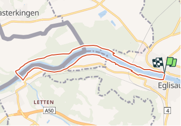
Trail Other activity of 8.8 km to be discovered at Zurich, Bezirk Bülach, Eglisau. This trail is proposed by redfam01.
Description
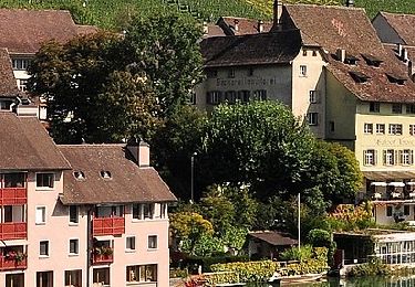
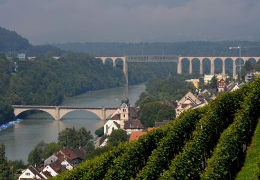
Die Wanderung führt flussabwärts auf der rechten Seite. Vergessen Sie die ID nicht, denn Sie gehen über die Grüne Grenze! Bei Rheinfelden erreichen Sie das Kraftwerk, wo Sie auf die Schweizer Seite wechseln.
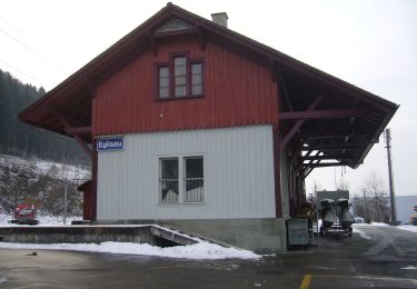
Danach geht es zurück richtung Egliau.
Positioning
Country:
Switzerland
Region :
Zurich
Department/Province :
Bezirk Bülach
Municipality :
Eglisau
Location:
Unknown
Start:(Dec)
Start:(UTM)
464053 ; 5269304 (32T) N.
Comments
Trails nearby
![Trail On foot Berg am Irchel - Irchel Hochwacht - Winterthur - Photo](https://media.geolcdn.com/t/375/260/ext.jpg?maxdim=2&url=https%3A%2F%2Fmedia.geolcdn.com%2Ff%2F9021b627-b640-4c62-a56f-c97534999414.jpeg)
![On foot On foot](https://static1.geolcdn.com/sitytour/trail-icons/100.png)
Irchel Hochwacht - Winterthur
On foot
Medium
Berg am Irchel,
Zurich,
Bezirk Andelfingen,
Switzerland
![](/images/other/stat-length.png)
16.3 km | 20 km-effort
4h 35min
![](https://static1.geolcdn.com/siteimages/upload/files/16400158638029165_repeat_loop_refresh_sync_direction_icon.png)
No
![Trail On foot Rüdlingen - Rüdlingen - Eglisau Bahnhof - Photo](https://media.geolcdn.com/t/375/260/ext.jpg?maxdim=2&url=https%3A%2F%2Fmedia.geolcdn.com%2Ff%2F11928e1e-b873-4037-a2f8-08a87f5da9bf.jpeg)
![On foot On foot](https://static1.geolcdn.com/sitytour/trail-icons/100.png)
Rüdlingen - Eglisau Bahnhof
On foot
Easy
Rüdlingen,
Schaffhausen,
Unknown,
Switzerland
![](/images/other/stat-length.png)
6.3 km | 9.1 km-effort
2h 4min
![](https://static1.geolcdn.com/siteimages/upload/files/16400158638029165_repeat_loop_refresh_sync_direction_icon.png)
No
![Trail On foot Rüdlingen - Rüdlingen - Ellikon am Rhein - Photo](https://media.geolcdn.com/t/375/260/ext.jpg?maxdim=2&url=https%3A%2F%2Fmedia.geolcdn.com%2Ff%2F25c4e05d-745d-4279-a6b0-ba809d7600a9.jpeg)
![On foot On foot](https://static1.geolcdn.com/sitytour/trail-icons/100.png)
Rüdlingen - Ellikon am Rhein
On foot
Easy
Rüdlingen,
Schaffhausen,
Unknown,
Switzerland
![](/images/other/stat-length.png)
4.2 km | 4.7 km-effort
1h 4min
![](https://static1.geolcdn.com/siteimages/upload/files/16400158638029165_repeat_loop_refresh_sync_direction_icon.png)
No
![Trail On foot Rafz - Rafz - Eglisau Bahnhof - Photo](https://media.geolcdn.com/t/375/260/ext.jpg?maxdim=2&url=https%3A%2F%2Fmedia.geolcdn.com%2Ff%2Fdb32595a-b7f7-4371-b947-c2ac8504042d.jpeg)
![On foot On foot](https://static1.geolcdn.com/sitytour/trail-icons/100.png)
Rafz - Eglisau Bahnhof
On foot
Easy
Rafz,
Zurich,
Bezirk Bülach,
Switzerland
![](/images/other/stat-length.png)
5.4 km | 6.3 km-effort
1h 26min
![](https://static1.geolcdn.com/siteimages/upload/files/16400158638029165_repeat_loop_refresh_sync_direction_icon.png)
No
![Trail On foot Eglisau - Eglisau Bahnhof - Rüdlingen - Photo](https://media.geolcdn.com/t/375/260/ext.jpg?maxdim=2&url=https%3A%2F%2Fmedia.geolcdn.com%2Ff%2F11928e1e-b873-4037-a2f8-08a87f5da9bf.jpeg)
![On foot On foot](https://static1.geolcdn.com/sitytour/trail-icons/100.png)
Eglisau Bahnhof - Rüdlingen
On foot
Easy
Eglisau,
Zurich,
Bezirk Bülach,
Switzerland
![](/images/other/stat-length.png)
6 km | 8.1 km-effort
1h 50min
![](https://static1.geolcdn.com/siteimages/upload/files/16400158638029165_repeat_loop_refresh_sync_direction_icon.png)
No
![Trail On foot Flaach - Scheublisallmend - Thurhof - Photo](https://media.geolcdn.com/t/375/260/ext.jpg?maxdim=2&url=https%3A%2F%2Fmedia.geolcdn.com%2Ff%2Fdaccca04-78af-4d11-ac2d-cc1fe3034220.jpeg)
![On foot On foot](https://static1.geolcdn.com/sitytour/trail-icons/100.png)
Scheublisallmend - Thurhof
On foot
Easy
Flaach,
Zurich,
Bezirk Andelfingen,
Switzerland
![](/images/other/stat-length.png)
3.1 km | 3.5 km-effort
48min
![](https://static1.geolcdn.com/siteimages/upload/files/16400158638029165_repeat_loop_refresh_sync_direction_icon.png)
No
![Trail On foot Eglisau - Eglisau Bahnhof - Winterthur - Photo](https://media.geolcdn.com/t/375/260/ext.jpg?maxdim=2&url=https%3A%2F%2Fmedia.geolcdn.com%2Ff%2F90ecdb9f-56be-4fc0-a521-33a498f72cf2.jpeg)
![On foot On foot](https://static1.geolcdn.com/sitytour/trail-icons/100.png)
Eglisau Bahnhof - Winterthur
On foot
Medium
Eglisau,
Zurich,
Bezirk Bülach,
Switzerland
![](/images/other/stat-length.png)
24 km | 29 km-effort
6h 40min
![](https://static1.geolcdn.com/siteimages/upload/files/16400158638029165_repeat_loop_refresh_sync_direction_icon.png)
No
![Trail On foot Eglisau - Eglisau Bahnhof - Tössegg Schiffsteg - Photo](https://media.geolcdn.com/t/375/260/ext.jpg?maxdim=2&url=https%3A%2F%2Fmedia.geolcdn.com%2Ff%2Fde0dcb80-949d-4896-aade-9c2e074405fd.jpeg)
![On foot On foot](https://static1.geolcdn.com/sitytour/trail-icons/100.png)
Eglisau Bahnhof - Tössegg Schiffsteg
On foot
Easy
Eglisau,
Zurich,
Bezirk Bülach,
Switzerland
![](/images/other/stat-length.png)
4.6 km | 5.3 km-effort
1h 12min
![](https://static1.geolcdn.com/siteimages/upload/files/16400158638029165_repeat_loop_refresh_sync_direction_icon.png)
No
![Trail On foot Eglisau - Eglisau Bahnhof - Tössriederen - Photo](https://media.geolcdn.com/t/375/260/ext.jpg?maxdim=2&url=https%3A%2F%2Fmedia.geolcdn.com%2Ff%2Fdb32595a-b7f7-4371-b947-c2ac8504042d.jpeg)
![On foot On foot](https://static1.geolcdn.com/sitytour/trail-icons/100.png)
Eglisau Bahnhof - Tössriederen
On foot
Easy
Eglisau,
Zurich,
Bezirk Bülach,
Switzerland
![](/images/other/stat-length.png)
3 km | 3.4 km-effort
45min
![](https://static1.geolcdn.com/siteimages/upload/files/16400158638029165_repeat_loop_refresh_sync_direction_icon.png)
No