![](/images/other/stat-length.png)
![Trail Walking Vallouise-Pelvoux - Le Pointu - Photo](https://media.geolcdn.com/t/1900/400/8693b583-9a13-4a1b-bdb1-7d8261f6df26.jpg&format=pjpeg&maxdim=2)
Le Pointu
dmarquaire
User
![Length](/images/other/stat-length.png)
Length
4.9 km
![Max alt](https://static1.geolcdn.com/siteimages/upload/files/1508320355ic_sort_altitude_max_24dp.png)
Max alt
1577 m
![Uphill gradient](https://static1.geolcdn.com/siteimages/upload/files/1508320355ic_sort_den_pos_24dp.png)
Uphill gradient
363 m
![Km-Effort](/images/other/stat-length.png)
Km-Effort
9.7 km
![Min alt](https://static1.geolcdn.com/siteimages/upload/files/1508320355ic_sort_altitude_min_24dp.png)
Min alt
1206 m
![Downhill gradient](https://static1.geolcdn.com/siteimages/upload/files/1508320355ic_sort_den_neg_24dp.png)
Downhill gradient
364 m
![Boucle](https://static1.geolcdn.com/siteimages/upload/files/16400158638029165_repeat_loop_refresh_sync_direction_icon.png)
Boucle
Yes
Creation date :
2019-07-31 07:42:56.0
Updated on :
2019-07-31 10:25:23.024
![Walking](https://static1.geolcdn.com/sitytour/trail-icons/101.png)
2h36
Difficulty : Medium
![Scan this QR Code to open this trail in the SityTrail application](https://capi.geolives.com/qq0zvz2zws4bq2lad0pu/sitytour/trails/2155261/qr.png?size=200)
FREE GPS app for hiking
About
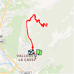
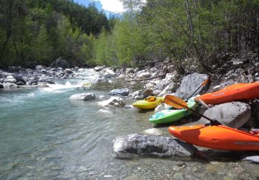
Trail Walking of 4.9 km to be discovered at Provence-Alpes-Côte d'Azur, Hautes-Alpes, Vallouise-Pelvoux. This trail is proposed by dmarquaire.
Description
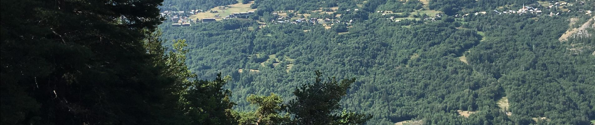
Au départ de la casse belle.montee à l ‘ombre. Vue sur Puy st VINCENT le Narreyrou les Bancs le Pelvoux Le Glacier blanc
Positioning
Country:
France
Region :
Provence-Alpes-Côte d'Azur
Department/Province :
Hautes-Alpes
Municipality :
Vallouise-Pelvoux
Location:
Vallouise
Start:(Dec)
Start:(UTM)
302481 ; 4968385 (32T) N.
Comments
Trails nearby
![Trail Walking Puy-Saint-Vincent - La tête d'Oreac - Photo](https://media.geolcdn.com/t/375/260/174c5726-c513-49d1-a693-65730cdb6179.jpg&format=jpg&maxdim=2)
![Walking Walking](https://static1.geolcdn.com/sitytour/trail-icons/101.png)
La tête d'Oreac
Walking
Easy
(2)
Puy-Saint-Vincent,
Provence-Alpes-Côte d'Azur,
Hautes-Alpes,
France
![](/images/other/stat-length.png)
6 km | 10.4 km-effort
3h 55min
![](https://static1.geolcdn.com/siteimages/upload/files/16400158638029165_repeat_loop_refresh_sync_direction_icon.png)
Yes
![Trail Walking Vallouise-Pelvoux - traversé du pelvoux - Photo](https://media.geolcdn.com/t/375/260/ext.jpg?maxdim=2&url=https%3A%2F%2Fservices.sitytrail.com%2FGeolivesWS%2FDownloadMedia.ashx%3FTrailID%3D593533%26Media%3Dfix__20160628143021.jpg)
![Walking Walking](https://static1.geolcdn.com/sitytour/trail-icons/101.png)
traversé du pelvoux
Walking
Very easy
(2)
Vallouise-Pelvoux,
Provence-Alpes-Côte d'Azur,
Hautes-Alpes,
France
![](/images/other/stat-length.png)
25 km | 58 km-effort
19h 10min
![](https://static1.geolcdn.com/siteimages/upload/files/16400158638029165_repeat_loop_refresh_sync_direction_icon.png)
No
![Trail Walking Puy-Saint-Vincent - Cascades de Narreyroux - Puy Saint Vincent - Photo](https://media.geolcdn.com/t/375/260/ext.jpg?maxdim=2&url=https%3A%2F%2Fservices.sitytrail.com%2FGeolivesWS%2FDownloadMedia.ashx%3FTrailID%3D215154%26Media%3D15749_4.jpg)
![Walking Walking](https://static1.geolcdn.com/sitytour/trail-icons/101.png)
Cascades de Narreyroux - Puy Saint Vincent
Walking
Difficult
(1)
Puy-Saint-Vincent,
Provence-Alpes-Côte d'Azur,
Hautes-Alpes,
France
![](/images/other/stat-length.png)
11.4 km | 19.2 km-effort
4h 0min
![](https://static1.geolcdn.com/siteimages/upload/files/16400158638029165_repeat_loop_refresh_sync_direction_icon.png)
Yes
![Trail On foot Vallouise-Pelvoux - Boucle vers Puy Aillaud - Photo](https://media.geolcdn.com/t/375/260/eef3011a-32af-4790-a416-25706592918e.jpeg&format=jpg&maxdim=2)
![On foot On foot](https://static1.geolcdn.com/sitytour/trail-icons/100.png)
Boucle vers Puy Aillaud
On foot
Easy
Vallouise-Pelvoux,
Provence-Alpes-Côte d'Azur,
Hautes-Alpes,
France
![](/images/other/stat-length.png)
5.3 km | 10.2 km-effort
2h 19min
![](https://static1.geolcdn.com/siteimages/upload/files/16400158638029165_repeat_loop_refresh_sync_direction_icon.png)
No
![Trail On foot Vallouise-Pelvoux - Boucle de Pelvoux - Photo](https://media.geolcdn.com/t/375/260/5ff99f02-24ff-4116-85ce-efee1281dc27.jpeg&format=jpg&maxdim=2)
![On foot On foot](https://static1.geolcdn.com/sitytour/trail-icons/100.png)
Boucle de Pelvoux
On foot
Easy
Vallouise-Pelvoux,
Provence-Alpes-Côte d'Azur,
Hautes-Alpes,
France
![](/images/other/stat-length.png)
12.2 km | 18.7 km-effort
4h 15min
![](https://static1.geolcdn.com/siteimages/upload/files/16400158638029165_repeat_loop_refresh_sync_direction_icon.png)
Yes
![Trail On foot Vallouise-Pelvoux - Boucle de Vallouise - Photo](https://media.geolcdn.com/t/375/260/d4c61dbc-be31-4372-8648-4be9dfe9a2a3.jpeg&format=jpg&maxdim=2)
![On foot On foot](https://static1.geolcdn.com/sitytour/trail-icons/100.png)
Boucle de Vallouise
On foot
Easy
Vallouise-Pelvoux,
Provence-Alpes-Côte d'Azur,
Hautes-Alpes,
France
![](/images/other/stat-length.png)
8.1 km | 11.6 km-effort
2h 38min
![](https://static1.geolcdn.com/siteimages/upload/files/16400158638029165_repeat_loop_refresh_sync_direction_icon.png)
Yes
![Trail On foot Les Vigneaux - Tour des Vigneaux - Photo](https://media.geolcdn.com/t/375/260/fd3b5f61-26ba-4d1e-9af2-366d68bf8117.jpeg&format=jpg&maxdim=2)
![On foot On foot](https://static1.geolcdn.com/sitytour/trail-icons/100.png)
Tour des Vigneaux
On foot
Easy
Les Vigneaux,
Provence-Alpes-Côte d'Azur,
Hautes-Alpes,
France
![](/images/other/stat-length.png)
5.7 km | 7.5 km-effort
1h 42min
![](https://static1.geolcdn.com/siteimages/upload/files/16400158638029165_repeat_loop_refresh_sync_direction_icon.png)
Yes
![Trail Snowshoes Puy-Saint-Vincent - la tête d'Oréac - Photo](https://media.geolcdn.com/t/375/260/f97877d2-86be-4ba2-b92e-863cfeff071e.jpg&format=jpg&maxdim=2)
![Snowshoes Snowshoes](https://static1.geolcdn.com/sitytour/trail-icons/504.png)
la tête d'Oréac
Snowshoes
Medium
Puy-Saint-Vincent,
Provence-Alpes-Côte d'Azur,
Hautes-Alpes,
France
![](/images/other/stat-length.png)
6.4 km | 11.4 km-effort
4h 7min
![](https://static1.geolcdn.com/siteimages/upload/files/16400158638029165_repeat_loop_refresh_sync_direction_icon.png)
Yes
![Trail Walking Puy-Saint-Vincent - le lac des Hermes - Photo](https://media.geolcdn.com/t/375/260/ext.jpg?maxdim=2&url=https%3A%2F%2Fservices.sitytrail.com%2FGeolivesWS%2FDownloadMedia.ashx%3FTrailID%3D731563%26Media%3Dfix__20170411163111.jpg)
![Walking Walking](https://static1.geolcdn.com/sitytour/trail-icons/101.png)
le lac des Hermes
Walking
Easy
Puy-Saint-Vincent,
Provence-Alpes-Côte d'Azur,
Hautes-Alpes,
France
![](/images/other/stat-length.png)
4.3 km | 6.5 km-effort
3h 9min
![](https://static1.geolcdn.com/siteimages/upload/files/16400158638029165_repeat_loop_refresh_sync_direction_icon.png)
Yes