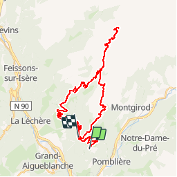
![](/images/other/stat-length.png)
![Trail Electric bike Hautecour - Boucle Hautecour - refuge du Nant du Beurre - Photo](https://media.geolcdn.com/t/1900/400/ext.pjpeg?maxdim=2&url=https%3A%2F%2Fstatic1.geolcdn.com%2Fsiteimages%2Fupload%2Ffiles%2F1524743154velo.jpg)
Boucle Hautecour - refuge du Nant du Beurre
franquen
User
![Length](/images/other/stat-length.png)
![Max alt](https://static1.geolcdn.com/siteimages/upload/files/1508320355ic_sort_altitude_max_24dp.png)
![Uphill gradient](https://static1.geolcdn.com/siteimages/upload/files/1508320355ic_sort_den_pos_24dp.png)
![Km-Effort](/images/other/stat-length.png)
![Min alt](https://static1.geolcdn.com/siteimages/upload/files/1508320355ic_sort_altitude_min_24dp.png)
![Downhill gradient](https://static1.geolcdn.com/siteimages/upload/files/1508320355ic_sort_den_neg_24dp.png)
![Boucle](https://static1.geolcdn.com/siteimages/upload/files/16400158638029165_repeat_loop_refresh_sync_direction_icon.png)
![Electric bike](https://static1.geolcdn.com/sitytour/trail-icons/205.png)
5h55
Difficulty : Medium
![Scan this QR Code to open this trail in the SityTrail application](https://capi.geolives.com/qq0zvz2zws4bq2lad0pu/sitytour/trails/2154642/qr.png?size=200)
FREE GPS app for hiking
About
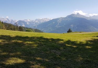
Trail Electric bike of 40 km to be discovered at Auvergne-Rhône-Alpes, Savoy, Hautecour. This trail is proposed by franquen.
Description
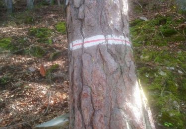
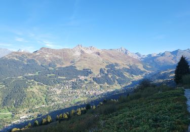
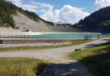
partis de Hautecour le Breuil, montée au refuge du Nant de Beurre, essai d'aller au col des Tufs Blancs mais après le col du Crêtet la piste était trop creusée pour les vélos. Retour par Navette et montée assez raide pour rejoindre Hautecour. Superbe vue du refuge sur la vallée de Valmorel.
Positioning
Comments
Trails nearby
![Trail Walking Les Belleville - Tour de Creve Tete - Photo](https://media.geolcdn.com/t/375/260/775f7fbd-61fe-4dac-aa88-5ad251aeb72f.jpg&format=jpg&maxdim=2)
![Walking Walking](https://static1.geolcdn.com/sitytour/trail-icons/101.png)
Walking
![](/images/other/stat-length.png)
![](https://static1.geolcdn.com/siteimages/upload/files/16400158638029165_repeat_loop_refresh_sync_direction_icon.png)
![Trail Walking Feissons-sur-Salins - Rando à Feissons - Photo](https://media.geolcdn.com/t/375/260/063eb2f4-6bf4-4b4a-a131-fc9697177278.jpg&format=jpg&maxdim=2)
![Walking Walking](https://static1.geolcdn.com/sitytour/trail-icons/101.png)
Walking
![](/images/other/stat-length.png)
![](https://static1.geolcdn.com/siteimages/upload/files/16400158638029165_repeat_loop_refresh_sync_direction_icon.png)
![Trail Walking Feissons-sur-Salins - Croix de Feissons - Photo](https://media.geolcdn.com/t/375/260/ext.jpg?maxdim=2&url=https%3A%2F%2Fservices.sitytrail.com%2FGeolivesWS%2FDownloadMedia.ashx%3FTrailID%3D958597%26Media%3D3ded4b2c-a6b8-4dd9-b494-9ab426781ec1.jpg)
![Walking Walking](https://static1.geolcdn.com/sitytour/trail-icons/101.png)
Walking
![](/images/other/stat-length.png)
![](https://static1.geolcdn.com/siteimages/upload/files/16400158638029165_repeat_loop_refresh_sync_direction_icon.png)
![Trail Walking Hautecour - Le sentier artistique de Hautecour - Photo](https://media.geolcdn.com/t/375/260/ext.jpg?maxdim=2&url=https%3A%2F%2Fstatic1.geolcdn.com%2Fsiteimages%2Fupload%2Ffiles%2F1553511878bg_sport_marche.png)
![Walking Walking](https://static1.geolcdn.com/sitytour/trail-icons/101.png)
Walking
![](/images/other/stat-length.png)
![](https://static1.geolcdn.com/siteimages/upload/files/16400158638029165_repeat_loop_refresh_sync_direction_icon.png)
![Trail Walking Grand-Aigueblanche - Cascade du Morel-20-07-22 - Photo](https://media.geolcdn.com/t/375/260/f72b1eaf-d1a3-4853-ba57-b26ebe92f90e.jpg&format=jpg&maxdim=2)
![Walking Walking](https://static1.geolcdn.com/sitytour/trail-icons/101.png)
Walking
![](/images/other/stat-length.png)
![](https://static1.geolcdn.com/siteimages/upload/files/16400158638029165_repeat_loop_refresh_sync_direction_icon.png)
![Trail Walking Feissons-sur-Salins - Feissons sur salins / Bois du sapey - Photo](https://media.geolcdn.com/t/375/260/372d571c-3325-4051-9cd3-72995a78efc6.jpg&format=jpg&maxdim=2)
![Walking Walking](https://static1.geolcdn.com/sitytour/trail-icons/101.png)
Walking
![](/images/other/stat-length.png)
![](https://static1.geolcdn.com/siteimages/upload/files/16400158638029165_repeat_loop_refresh_sync_direction_icon.png)
![Trail Walking La Léchère - Ronchat La Cudraz Navette Plan des Heures Balcon des Adrets de Tarentaise - Photo](https://media.geolcdn.com/t/375/260/31bbd3e5-7eb6-4ecd-afbb-fb24a4602b0f.jpg&format=jpg&maxdim=2)
![Walking Walking](https://static1.geolcdn.com/sitytour/trail-icons/101.png)
Walking
![](/images/other/stat-length.png)
![](https://static1.geolcdn.com/siteimages/upload/files/16400158638029165_repeat_loop_refresh_sync_direction_icon.png)
![Trail Motorbike Les Belleville - rando menuires - Photo](https://media.geolcdn.com/t/375/260/6a459a38-d7c5-4ace-8cc3-add6d0d07428.jpg&format=jpg&maxdim=2)
![Motorbike Motorbike](https://static1.geolcdn.com/sitytour/trail-icons/402.png)
Motorbike
![](/images/other/stat-length.png)
![](https://static1.geolcdn.com/siteimages/upload/files/16400158638029165_repeat_loop_refresh_sync_direction_icon.png)
![Trail Walking Salins-Fontaine - 06 sept 21 - Photo](https://media.geolcdn.com/t/375/260/6ef0a44c-6415-4147-b6a2-b117d4cfbf6d.jpg&format=jpg&maxdim=2)
![Walking Walking](https://static1.geolcdn.com/sitytour/trail-icons/101.png)
Walking
![](/images/other/stat-length.png)
![](https://static1.geolcdn.com/siteimages/upload/files/16400158638029165_repeat_loop_refresh_sync_direction_icon.png)