![](/images/other/stat-length.png)
![Trail Walking Thoiry - Crêt de la Neige et Reculet - Thoiry - Photo](https://media.geolcdn.com/t/1900/400/ext.pjpeg?maxdim=2&url=https%3A%2F%2Fservices.sitytrail.com%2FGeolivesWS%2FDownloadMedia.ashx%3FTrailID%3D215216%26Media%3D15830_4.jpg)
Crêt de la Neige et Reculet - Thoiry
tracegps
User
![Length](/images/other/stat-length.png)
![Max alt](https://static1.geolcdn.com/siteimages/upload/files/1508320355ic_sort_altitude_max_24dp.png)
![Uphill gradient](https://static1.geolcdn.com/siteimages/upload/files/1508320355ic_sort_den_pos_24dp.png)
![Km-Effort](/images/other/stat-length.png)
![Min alt](https://static1.geolcdn.com/siteimages/upload/files/1508320355ic_sort_altitude_min_24dp.png)
![Downhill gradient](https://static1.geolcdn.com/siteimages/upload/files/1508320355ic_sort_den_neg_24dp.png)
![Boucle](https://static1.geolcdn.com/siteimages/upload/files/16400158638029165_repeat_loop_refresh_sync_direction_icon.png)
![Walking](https://static1.geolcdn.com/sitytour/trail-icons/101.png)
5h15
Difficulty : Difficult
![Scan this QR Code to open this trail in the SityTrail application](https://capi.geolives.com/qq0zvz2zws4bq2lad0pu/sitytour/trails/215216/qr.png?size=200)
FREE GPS app for hiking
About
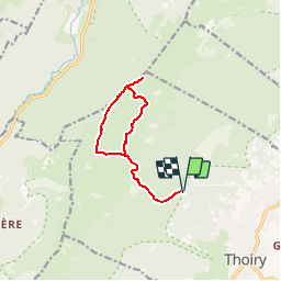
Trail Walking of 10.6 km to be discovered at Auvergne-Rhône-Alpes, Ain, Thoiry. This trail is proposed by tracegps.
Description
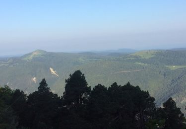
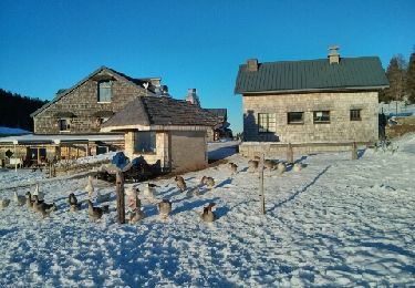
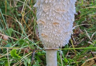
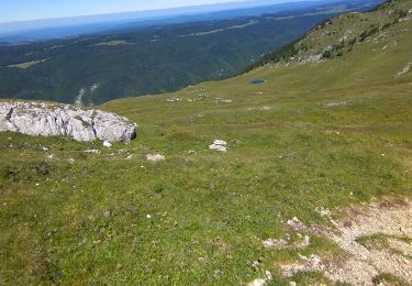
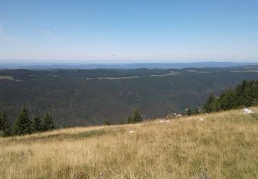
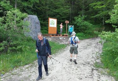
Montée: Prendre le sentier qui se situe à gauche du grand bâtiment sur le parking du Tiocan et s'enfonce directement dans la forêt. Laisser à droite le chemin indiqué « Reculet par la Beule ». Après une courte montée, très vite on croise un chemin gravillonné qu'il faut traverser pour continuer le sentier qui s'élève de façon assez raide dans la forêt. Une bonne part du dénivelé se fait dans cette forêt où il n'est pas rare de croiser de jeunes chamois assez craintifs. Arrive maintenant la jonction avec le chemin empierré qu'il faut suivre jusqu'à une bifurcation où il faut prendre à droite en direction du Reculet et laisser sur la gauche le chalet de Narderant. Le sentier se fait assez raide jusqu'au débouché de la forêt : de là, la croix au sommet du Reculet est bien visible sur la gauche. Continuer le sentier jusqu'à une bifurcation qui invite à suivre, à droite, la direction du Crêt de la Neige. Puis, continuer jusqu'à un croisement pour suivre à gauche la direction du Crêt. Après une courte montée, le sentier rejoint le GR du Tour de la Valserine qui mène à notre premier objectif. L'itinéraire devient plus escarpé et tortille parmi les pins à crochets, curiosité du secteur, avant d'atteindre le Crêt de la Neige. Après une pause pour admirer ce magnifique point de vue sur le bassin Lémanique et la chaîne des Alpes toute proche, il faudra rebrousser chemin et se diriger vers le Reculet en gardant la croix en point de mire. Le sentier rejoint rapidement la base du Reculet qu'une dernière courte montée permet d'atteindre. Descente: Le sentier de la descente continue dans le prolongement de celui pris à la montée et tire tout droit dans la prairie. Après une descente escarpée délicate par endroits, le sentier rejoint l'itinéraire de la montée au niveau de deux réservoirs à eau, circulaires, qu'on a laissés à droite à la montée. La partie délicate de la descente commence maintenant sur ce sentier caillouteux qui met les jambes à rude épreuve.
Positioning
Comments
Trails nearby
![Trail Walking Lélex - GR 9 - Étape 9 - Refuge de la Loge - Menthière - Photo](https://media.geolcdn.com/t/375/260/dc9a21eb-d019-4c3c-b4f9-163ce6ee3bf5.jpg&format=jpg&maxdim=2)
![Walking Walking](https://static1.geolcdn.com/sitytour/trail-icons/101.png)
Walking
![](/images/other/stat-length.png)
![](https://static1.geolcdn.com/siteimages/upload/files/16400158638029165_repeat_loop_refresh_sync_direction_icon.png)
![Trail Walking Thoiry - Le Reculet Le Crêt de la Neige - Photo](https://media.geolcdn.com/t/375/260/ext.jpg?maxdim=2&url=https%3A%2F%2Fstatic1.geolcdn.com%2Fsiteimages%2Fupload%2Ffiles%2F1553511878bg_sport_marche.png)
![Walking Walking](https://static1.geolcdn.com/sitytour/trail-icons/101.png)
Walking
![](/images/other/stat-length.png)
![](https://static1.geolcdn.com/siteimages/upload/files/16400158638029165_repeat_loop_refresh_sync_direction_icon.png)
![Trail Walking Thoiry - Le Reculet - Photo](https://media.geolcdn.com/t/375/260/ext.jpg?maxdim=2&url=https%3A%2F%2Fservices.sitytrail.com%2FGeolivesWS%2FDownloadMedia.ashx%3FTrailID%3D306851%26Media%3Dfix__20140529150026.jpg)
![Walking Walking](https://static1.geolcdn.com/sitytour/trail-icons/101.png)
Walking
![](/images/other/stat-length.png)
![](https://static1.geolcdn.com/siteimages/upload/files/16400158638029165_repeat_loop_refresh_sync_direction_icon.png)
![Trail Snowshoes Chézery-Forens - les Closettes - Photo](https://media.geolcdn.com/t/375/260/ext.jpg?maxdim=2&url=https%3A%2F%2Fservices.sitytrail.com%2FGeolivesWS%2FDownloadMedia.ashx%3FTrailID%3D236480%26Media%3Dfix__20131208155612.jpg)
![Snowshoes Snowshoes](https://static1.geolcdn.com/sitytour/trail-icons/504.png)
Snowshoes
![](/images/other/stat-length.png)
![](https://static1.geolcdn.com/siteimages/upload/files/16400158638029165_repeat_loop_refresh_sync_direction_icon.png)
![Trail Walking Lélex - Boucle Reculet - Cret de la neige - Photo](https://media.geolcdn.com/t/375/260/cd8cfe71-ab0d-4b1d-99f8-09e2342478ed.jpg&format=jpg&maxdim=2)
![Walking Walking](https://static1.geolcdn.com/sitytour/trail-icons/101.png)
Walking
![](/images/other/stat-length.png)
![](https://static1.geolcdn.com/siteimages/upload/files/16400158638029165_repeat_loop_refresh_sync_direction_icon.png)
![Trail Walking Lélex - Lelex-cret de la neige - Photo](https://media.geolcdn.com/t/375/260/8740e436-5fd7-4ce2-8a41-71075bb8b87a.jpg&format=jpg&maxdim=2)
![Walking Walking](https://static1.geolcdn.com/sitytour/trail-icons/101.png)
Walking
![](/images/other/stat-length.png)
![](https://static1.geolcdn.com/siteimages/upload/files/16400158638029165_repeat_loop_refresh_sync_direction_icon.png)
![Trail Walking Chézery-Forens - Chezery Le Reculet - Photo](https://media.geolcdn.com/t/375/260/998221fb-94cc-4039-9621-20ae86572284.jpg&format=jpg&maxdim=2)
![Walking Walking](https://static1.geolcdn.com/sitytour/trail-icons/101.png)
Walking
![](/images/other/stat-length.png)
![](https://static1.geolcdn.com/siteimages/upload/files/16400158638029165_repeat_loop_refresh_sync_direction_icon.png)
![Trail Walking Lélex - lelex-cret de la neige - Photo](https://media.geolcdn.com/t/375/260/caffb944-7c7e-4c3a-8bb8-ac84c949f206.jpg&format=jpg&maxdim=2)
![Walking Walking](https://static1.geolcdn.com/sitytour/trail-icons/101.png)
Walking
![](/images/other/stat-length.png)
![](https://static1.geolcdn.com/siteimages/upload/files/16400158638029165_repeat_loop_refresh_sync_direction_icon.png)
![Trail Walking Lélex - rando n1 - Photo](https://media.geolcdn.com/t/375/260/517490b1-95c9-4dbe-b124-cd2e27675713.jpg&format=jpg&maxdim=2)
![Walking Walking](https://static1.geolcdn.com/sitytour/trail-icons/101.png)
Walking
![](/images/other/stat-length.png)
![](https://static1.geolcdn.com/siteimages/upload/files/16400158638029165_repeat_loop_refresh_sync_direction_icon.png)