![](/images/other/stat-length.png)
![Trail Walking Chastre - SityTrail - Promenade de Villeroux - Photo](https://media.geolcdn.com/t/1900/400/ext.pjpeg?maxdim=2&url=https%3A%2F%2Fstatic1.geolcdn.com%2Fsiteimages%2Fupload%2Ffiles%2F1553511878bg_sport_marche.png)
SityTrail - Promenade de Villeroux
vindju
User
![Length](/images/other/stat-length.png)
Length
6.7 km
![Max alt](https://static1.geolcdn.com/siteimages/upload/files/1508320355ic_sort_altitude_max_24dp.png)
Max alt
152 m
![Uphill gradient](https://static1.geolcdn.com/siteimages/upload/files/1508320355ic_sort_den_pos_24dp.png)
Uphill gradient
63 m
![Km-Effort](/images/other/stat-length.png)
Km-Effort
7.5 km
![Min alt](https://static1.geolcdn.com/siteimages/upload/files/1508320355ic_sort_altitude_min_24dp.png)
Min alt
115 m
![Downhill gradient](https://static1.geolcdn.com/siteimages/upload/files/1508320355ic_sort_den_neg_24dp.png)
Downhill gradient
65 m
![Boucle](https://static1.geolcdn.com/siteimages/upload/files/16400158638029165_repeat_loop_refresh_sync_direction_icon.png)
Boucle
Yes
Creation date :
2019-07-28 06:21:33.141
Updated on :
2020-07-03 07:02:59.703
![Walking](https://static1.geolcdn.com/sitytour/trail-icons/101.png)
1h53
Difficulty : Medium
![Scan this QR Code to open this trail in the SityTrail application](https://capi.geolives.com/qq0zvz2zws4bq2lad0pu/sitytour/trails/2151795/qr.png?size=200)
FREE GPS app for hiking
About
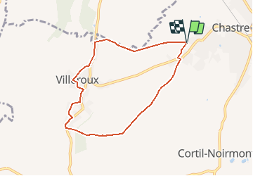
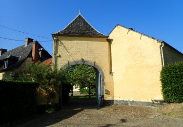
Trail Walking of 6.7 km to be discovered at Wallonia, Walloon Brabant, Chastre. This trail is proposed by vindju.
Description
Cette promenade entre vallée et plateau démarre à l'église de Chastre, se dirige vers Villeroux à travers les champs puis parcourt la vallée de la Houssière.
Points of interest
Positioning
Country:
Belgium
Region :
Wallonia
Department/Province :
Walloon Brabant
Municipality :
Chastre
Location:
Chastre-Villeroux-Blanmont
Start:(Dec)
Start:(UTM)
615581 ; 5607496 (31U) N.
Comments
Trails nearby
![Trail Walking Mont-Saint-Guibert - Balade à Mont-Saint-Guibert - Photo](https://media.geolcdn.com/t/375/260/ext.jpg?maxdim=2&url=https%3A%2F%2Fservices.sitytrail.com%2FGeolivesWS%2FDownloadMedia.ashx%3FTrailID%3D942864%26Media%3D4a857fe0-cf43-4eb8-b563-62b2b90d4fc2.jpg)
![Walking Walking](https://static1.geolcdn.com/sitytour/trail-icons/101.png)
Balade à Mont-Saint-Guibert
Walking
Very easy
(1)
Mont-Saint-Guibert,
Wallonia,
Walloon Brabant,
Belgium
![](/images/other/stat-length.png)
8.4 km | 10.1 km-effort
2h 12min
![](https://static1.geolcdn.com/siteimages/upload/files/16400158638029165_repeat_loop_refresh_sync_direction_icon.png)
Yes
![Trail Walking Court-Saint-Étienne - RB-BW-08 - À la rencontre de trois vallées - Photo](https://media.geolcdn.com/t/375/260/ext.jpg?maxdim=2&url=https%3A%2F%2Fservices.sitytrail.com%2FGeolivesWS%2FDownloadMedia.ashx%3FTrailID%3D220267%26Media%3D6c86831f-6220-45af-ac63-82e6ea37f2ed.jpg)
![Walking Walking](https://static1.geolcdn.com/sitytour/trail-icons/101.png)
RB-BW-08 - À la rencontre de trois vallées
Walking
Very difficult
(2)
Court-Saint-Étienne,
Wallonia,
Walloon Brabant,
Belgium
![](/images/other/stat-length.png)
26 km | 32 km-effort
7h 18min
![](https://static1.geolcdn.com/siteimages/upload/files/16400158638029165_repeat_loop_refresh_sync_direction_icon.png)
Yes
![Trail Walking Chastre - #240223a - Blanmont, Orne, Alvaux, Nil Pierreux*** - Photo](https://media.geolcdn.com/t/375/260/ext.jpg?maxdim=2&url=https%3A%2F%2Fmedia.geolcdn.com%2Ff%2F93f4f268-f0dd-4755-9fda-3b9155347db7.JPG)
![Walking Walking](https://static1.geolcdn.com/sitytour/trail-icons/101.png)
#240223a - Blanmont, Orne, Alvaux, Nil Pierreux***
Walking
Medium
(1)
Chastre,
Wallonia,
Walloon Brabant,
Belgium
![](/images/other/stat-length.png)
6.6 km | 7.8 km-effort
1h 47min
![](https://static1.geolcdn.com/siteimages/upload/files/16400158638029165_repeat_loop_refresh_sync_direction_icon.png)
Yes
![Trail Walking Court-Saint-Étienne - Avenue des Rossignols - Photo](https://media.geolcdn.com/t/375/260/ext.jpg?maxdim=2&url=https%3A%2F%2Fmedia.geolcdn.com%2Ff%2F0934785a-3707-4824-af89-7c509e828e07.JPG)
![Walking Walking](https://static1.geolcdn.com/sitytour/trail-icons/101.png)
Avenue des Rossignols
Walking
Medium
(1)
Court-Saint-Étienne,
Wallonia,
Walloon Brabant,
Belgium
![](/images/other/stat-length.png)
5.8 km | 6.8 km-effort
1h 33min
![](https://static1.geolcdn.com/siteimages/upload/files/16400158638029165_repeat_loop_refresh_sync_direction_icon.png)
No
![Trail Walking Chastre - #230728 - Gentinnes Kongolo - Photo](https://media.geolcdn.com/t/375/260/ext.jpg?maxdim=2&url=https%3A%2F%2Fmedia.geolcdn.com%2Ff%2Fb8e0ed62-13ad-4df2-8ddb-c88775d5e582.JPG)
![Walking Walking](https://static1.geolcdn.com/sitytour/trail-icons/101.png)
#230728 - Gentinnes Kongolo
Walking
Easy
(1)
Chastre,
Wallonia,
Walloon Brabant,
Belgium
![](/images/other/stat-length.png)
5 km | 5.6 km-effort
1h 16min
![](https://static1.geolcdn.com/siteimages/upload/files/16400158638029165_repeat_loop_refresh_sync_direction_icon.png)
Yes
![Trail On foot Walhain - #170829 - Nil Pierreux, carrières de quartzite, Moulin d'Al Poudre et Tour des Sarrasins*** - Photo](https://media.geolcdn.com/t/375/260/ext.jpg?maxdim=2&url=https%3A%2F%2Fmedia.geolcdn.com%2Ff%2F3f6d304f-08de-4d1a-b4cf-2557e45951c8.JPG)
![On foot On foot](https://static1.geolcdn.com/sitytour/trail-icons/100.png)
#170829 - Nil Pierreux, carrières de quartzite, Moulin d'Al Poudre et Tour de...
On foot
Very easy
(2)
Walhain,
Wallonia,
Walloon Brabant,
Belgium
![](/images/other/stat-length.png)
8.1 km | 9.9 km-effort
2h 0min
![](https://static1.geolcdn.com/siteimages/upload/files/16400158638029165_repeat_loop_refresh_sync_direction_icon.png)
Yes
![Trail Walking Chastre - Promenade de Villeroux - Photo](https://media.geolcdn.com/t/375/260/ext.jpg?maxdim=2&url=https%3A%2F%2Fservices.sitytrail.com%2FGeolivesWS%2FDownloadMedia.ashx%3FTrailID%3D233658%26Media%3D6ce217ee-b2e1-442a-b4a3-34a4ee262c13.JPG)
![Walking Walking](https://static1.geolcdn.com/sitytour/trail-icons/101.png)
Promenade de Villeroux
Walking
Medium
(1)
Chastre,
Wallonia,
Walloon Brabant,
Belgium
![](/images/other/stat-length.png)
7.6 km | 8.5 km-effort
1h 53min
![](https://static1.geolcdn.com/siteimages/upload/files/16400158638029165_repeat_loop_refresh_sync_direction_icon.png)
Yes
![Trail Walking Chastre - Balade récréative de Cortil - Photo](https://media.geolcdn.com/t/375/260/ext.jpg?maxdim=2&url=https%3A%2F%2Fservices.sitytrail.com%2FGeolivesWS%2FDownloadMedia.ashx%3FTrailID%3D232278%26Media%3D010369e0-b48e-4ca2-9215-837380cbac27.jpg)
![Walking Walking](https://static1.geolcdn.com/sitytour/trail-icons/101.png)
Balade récréative de Cortil
Walking
Easy
(4)
Chastre,
Wallonia,
Walloon Brabant,
Belgium
![](/images/other/stat-length.png)
5.9 km | 6.5 km-effort
1h 26min
![](https://static1.geolcdn.com/siteimages/upload/files/16400158638029165_repeat_loop_refresh_sync_direction_icon.png)
Yes
![Trail Walking Court-Saint-Étienne - Promenade 11 Suzeril et la vallée de la Thyle - Photo](https://media.geolcdn.com/t/375/260/ext.jpg?maxdim=2&url=https%3A%2F%2Fservices.sitytrail.com%2FGeolivesWS%2FDownloadMedia.ashx%3FTrailID%3D220354%26Media%3Dd68426e0-c29b-4ce9-a921-f69a4ba57f92.jpg)
![Walking Walking](https://static1.geolcdn.com/sitytour/trail-icons/101.png)
Promenade 11 Suzeril et la vallée de la Thyle
Walking
Easy
(1)
Court-Saint-Étienne,
Wallonia,
Walloon Brabant,
Belgium
![](/images/other/stat-length.png)
3.7 km | 4.5 km-effort
59min
![](https://static1.geolcdn.com/siteimages/upload/files/16400158638029165_repeat_loop_refresh_sync_direction_icon.png)
Yes