![](/images/other/stat-length.png)
![Trail Running Neaux - La route Napoléon et la Vallée du Gand à VTT - Neaux - Photo](https://media.geolcdn.com/t/1900/400/ext.pjpeg?maxdim=2&url=https%3A%2F%2Fservices.sitytrail.com%2FGeolivesWS%2FDownloadMedia.ashx%3FTrailID%3D215069%26Media%3D15641_6.jpg)
La route Napoléon et la Vallée du Gand à VTT - Neaux
tracegps
User
![Length](/images/other/stat-length.png)
![Max alt](https://static1.geolcdn.com/siteimages/upload/files/1508320355ic_sort_altitude_max_24dp.png)
![Uphill gradient](https://static1.geolcdn.com/siteimages/upload/files/1508320355ic_sort_den_pos_24dp.png)
![Km-Effort](/images/other/stat-length.png)
![Min alt](https://static1.geolcdn.com/siteimages/upload/files/1508320355ic_sort_altitude_min_24dp.png)
![Downhill gradient](https://static1.geolcdn.com/siteimages/upload/files/1508320355ic_sort_den_neg_24dp.png)
![Boucle](https://static1.geolcdn.com/siteimages/upload/files/16400158638029165_repeat_loop_refresh_sync_direction_icon.png)
![Running](https://static1.geolcdn.com/sitytour/trail-icons/103.png)
2h00
Difficulty : Medium
![Scan this QR Code to open this trail in the SityTrail application](https://capi.geolives.com/qq0zvz2zws4bq2lad0pu/sitytour/trails/215069/qr.png?size=200)
FREE GPS app for hiking
About
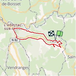
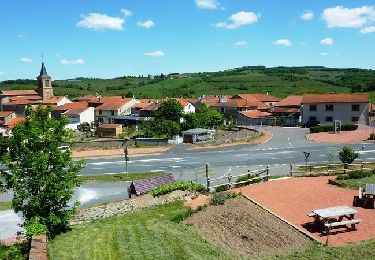
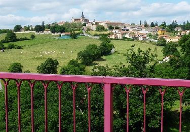
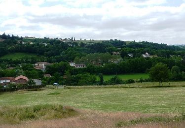
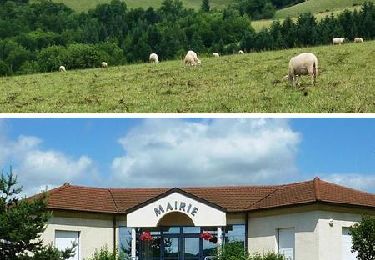
Trail Running of 11.7 km to be discovered at Auvergne-Rhône-Alpes, Loire, Neaux. This trail is proposed by tracegps.
Description
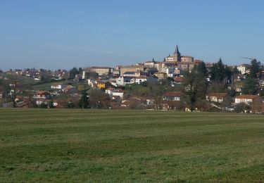
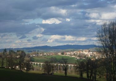
Départ du parking de la Mairie. Ce circuit qui est relativement facile commence par rejoindre le RN7 qu’on longe sur la petite sente sur la droite, puis c’est par une descente par la route Napoléon, route Royale avec de nombreux panneaux qui expliquent le parcours de l’Empereur que l’on rejoint L’Hôpital-sur-Rhins. Après le rond point (RN 7 et RN 82) on remonte tout doucement au bord de la rivière du Gand sur une belle piste au creux du vallon jusqu’à la carrière de Neaux. Puis on grimpe au dessus de la carrière et après les Roches il faut rester vigilant pour traverser la RN7 car la circulation est souvent dense. Après on descend vers l’étang (après le plan d’eau, regarder sur la droite pour apercevoir le viaduc de l’Ecoron) puis on continue l’ascension jusqu’à l’église du village pour enfin rejoindre le point de départ devant la mairie. Quelques passages aériens sur les crêtes offrent de somptueux panoramas sur le Roannais, les Monts de la Madeleine et du Beaujolais. Topoguide : Guide des Randonnées du Pays entre Loire et Rhône (Copler), 32 circuits balisés.
Positioning
Comments
Trails nearby
![Trail Walking Notre-Dame-de-Boisset - etang d'arcon-10 km - Photo](https://media.geolcdn.com/t/375/260/d0c0370c-bd7e-43b3-ab37-2c9497c641b2.jpg&format=jpg&maxdim=2)
![Walking Walking](https://static1.geolcdn.com/sitytour/trail-icons/101.png)
Walking
![](/images/other/stat-length.png)
![](https://static1.geolcdn.com/siteimages/upload/files/16400158638029165_repeat_loop_refresh_sync_direction_icon.png)
![Trail Walking Saint-Symphorien-de-Lay - etang st symphorien de lay - Photo](https://media.geolcdn.com/t/375/260/ext.jpg?maxdim=2&url=https%3A%2F%2Fstatic1.geolcdn.com%2Fsiteimages%2Fupload%2Ffiles%2F1553511878bg_sport_marche.png)
![Walking Walking](https://static1.geolcdn.com/sitytour/trail-icons/101.png)
Walking
![](/images/other/stat-length.png)
![](https://static1.geolcdn.com/siteimages/upload/files/16400158638029165_repeat_loop_refresh_sync_direction_icon.png)
![Trail Walking Saint-Symphorien-de-Lay - St Symphorien de lay, agri rando - Photo](https://media.geolcdn.com/t/375/260/ad65c851-00cb-4ac7-9236-117ab0c718e4.jpg&format=jpg&maxdim=2)
![Walking Walking](https://static1.geolcdn.com/sitytour/trail-icons/101.png)
Walking
![](/images/other/stat-length.png)
![](https://static1.geolcdn.com/siteimages/upload/files/16400158638029165_repeat_loop_refresh_sync_direction_icon.png)
![Walking Walking](https://static1.geolcdn.com/sitytour/trail-icons/101.png)
Walking
![](/images/other/stat-length.png)
![](https://static1.geolcdn.com/siteimages/upload/files/16400158638029165_repeat_loop_refresh_sync_direction_icon.png)
![Walking Walking](https://static1.geolcdn.com/sitytour/trail-icons/101.png)
Walking
![](/images/other/stat-length.png)
![](https://static1.geolcdn.com/siteimages/upload/files/16400158638029165_repeat_loop_refresh_sync_direction_icon.png)
![Trail Walking Vendranges - 29ème Randonnée des Vadrouillards (Grand circuit) - Vendranges - Photo](https://media.geolcdn.com/t/375/260/ext.jpg?maxdim=2&url=https%3A%2F%2Fservices.sitytrail.com%2FGeolivesWS%2FDownloadMedia.ashx%3FTrailID%3D317942%26Media%3D17373_6.jpg)
![Walking Walking](https://static1.geolcdn.com/sitytour/trail-icons/101.png)
Walking
![](/images/other/stat-length.png)
![](https://static1.geolcdn.com/siteimages/upload/files/16400158638029165_repeat_loop_refresh_sync_direction_icon.png)
![Trail Mountain bike Saint-Symphorien-de-Lay - VTT au creux des Vallées du Gand de l''Ecoron et du Rhins - Saint-Symphorien-de-Lay - Photo](https://media.geolcdn.com/t/375/260/ext.jpg?maxdim=2&url=https%3A%2F%2Fservices.sitytrail.com%2FGeolivesWS%2FDownloadMedia.ashx%3FTrailID%3D215281%26Media%3D15642_6.jpg)
![Mountain bike Mountain bike](https://static1.geolcdn.com/sitytour/trail-icons/202.png)
Mountain bike
![](/images/other/stat-length.png)
![](https://static1.geolcdn.com/siteimages/upload/files/16400158638029165_repeat_loop_refresh_sync_direction_icon.png)
![Trail Mountain bike Saint-Cyr-de-Favières - Découverte des villages de caractère à VTT - L''Hôpital-sur-Rhins - Photo](https://media.geolcdn.com/t/375/260/ext.jpg?maxdim=2&url=https%3A%2F%2Fservices.sitytrail.com%2FGeolivesWS%2FDownloadMedia.ashx%3FTrailID%3D215280%26Media%3D15640_6.jpg)
![Mountain bike Mountain bike](https://static1.geolcdn.com/sitytour/trail-icons/202.png)
Mountain bike
![](/images/other/stat-length.png)
![](https://static1.geolcdn.com/siteimages/upload/files/16400158638029165_repeat_loop_refresh_sync_direction_icon.png)
![Trail Mountain bike Neaux - La route Napoléon et la Vallée du Gand à VTT - Neaux - Photo](https://media.geolcdn.com/t/375/260/ext.jpg?maxdim=2&url=https%3A%2F%2Fservices.sitytrail.com%2FGeolivesWS%2FDownloadMedia.ashx%3FTrailID%3D215068%26Media%3D15641_6.jpg)
![Mountain bike Mountain bike](https://static1.geolcdn.com/sitytour/trail-icons/202.png)
Mountain bike
![](/images/other/stat-length.png)
![](https://static1.geolcdn.com/siteimages/upload/files/16400158638029165_repeat_loop_refresh_sync_direction_icon.png)