![](/images/other/stat-length.png)
![Trail Mountain bike Fournès - Les Fosses de Fournès - Photo](https://media.geolcdn.com/t/1900/400/ext.pjpeg?maxdim=2&url=https%3A%2F%2Fservices.sitytrail.com%2FGeolivesWS%2FDownloadMedia.ashx%3FTrailID%3D214950%26Media%3D15518_6.jpg)
Les Fosses de Fournès
tracegps
User
![Length](/images/other/stat-length.png)
Length
7.7 km
![Max alt](https://static1.geolcdn.com/siteimages/upload/files/1508320355ic_sort_altitude_max_24dp.png)
Max alt
140 m
![Uphill gradient](https://static1.geolcdn.com/siteimages/upload/files/1508320355ic_sort_den_pos_24dp.png)
Uphill gradient
177 m
![Km-Effort](/images/other/stat-length.png)
Km-Effort
10.1 km
![Min alt](https://static1.geolcdn.com/siteimages/upload/files/1508320355ic_sort_altitude_min_24dp.png)
Min alt
28 m
![Downhill gradient](https://static1.geolcdn.com/siteimages/upload/files/1508320355ic_sort_den_neg_24dp.png)
Downhill gradient
179 m
![Boucle](https://static1.geolcdn.com/siteimages/upload/files/16400158638029165_repeat_loop_refresh_sync_direction_icon.png)
Boucle
Yes
Creation date :
2014-12-10 00:00:00.0
Updated on :
2014-12-10 00:00:00.0
![Mountain bike](https://static1.geolcdn.com/sitytour/trail-icons/202.png)
1h30
Difficulty : Medium
![Scan this QR Code to open this trail in the SityTrail application](https://capi.geolives.com/qq0zvz2zws4bq2lad0pu/sitytour/trails/214950/qr.png?size=200)
FREE GPS app for hiking
About
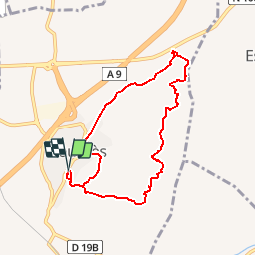
Trail Mountain bike of 7.7 km to be discovered at Occitania, Gard, Fournès. This trail is proposed by tracegps.
Description
Randonnée facile d'environ 2h00 sur de bons sentiers et chemins à faire toute l'année. Départ du parking de la mairie. Belle vue dégagée pendant une bonne partie de la balade. Dans Les Fosses de Fournès , on découvre un paysage de terre ravinée assez singulier. Bonne balade à tous !
Positioning
Country:
France
Region :
Occitania
Department/Province :
Gard
Municipality :
Fournès
Location:
Unknown
Start:(Dec)
Start:(UTM)
628422 ; 4864973 (31T) N.
Comments
Trails nearby
![Trail Walking Saint-Bonnet-du-Gard - Le Pont du Gard - Photo](https://media.geolcdn.com/t/375/260/ext.jpg?maxdim=2&url=https%3A%2F%2Fservices.sitytrail.com%2FGeolivesWS%2FDownloadMedia.ashx%3FTrailID%3D140741%26Media%3D20120722135743.jpeg)
![Walking Walking](https://static1.geolcdn.com/sitytour/trail-icons/101.png)
Le Pont du Gard
Walking
Difficult
(2)
Saint-Bonnet-du-Gard,
Occitania,
Gard,
France
![](/images/other/stat-length.png)
18.6 km | 24 km-effort
5h 30min
![](https://static1.geolcdn.com/siteimages/upload/files/16400158638029165_repeat_loop_refresh_sync_direction_icon.png)
Yes
![Trail Walking Saint-Bonnet-du-Gard - Chemins oubliés de l'Aqueduc - Photo](https://media.geolcdn.com/t/375/260/60ca721f-6c74-4f55-9fdb-9e35cb1dba72.jpg&format=jpg&maxdim=2)
![Walking Walking](https://static1.geolcdn.com/sitytour/trail-icons/101.png)
Chemins oubliés de l'Aqueduc
Walking
Medium
Saint-Bonnet-du-Gard,
Occitania,
Gard,
France
![](/images/other/stat-length.png)
12.7 km | 16.5 km-effort
3h 39min
![](https://static1.geolcdn.com/siteimages/upload/files/16400158638029165_repeat_loop_refresh_sync_direction_icon.png)
Yes
![Trail Walking Saint-Bonnet-du-Gard - SAINT BONNET DU GARD - PONT DU GARD - Variante - 15.8Km 05h00 - Dénivelé 410 m - Photo](https://media.geolcdn.com/t/375/260/ext.jpg?maxdim=2&url=https%3A%2F%2Fstatic1.geolcdn.com%2Fsiteimages%2Fupload%2Ffiles%2F1553511878bg_sport_marche.png)
![Walking Walking](https://static1.geolcdn.com/sitytour/trail-icons/101.png)
SAINT BONNET DU GARD - PONT DU GARD - Variante - 15.8Km 05h00 - Dénivelé 410 m
Walking
Difficult
(3)
Saint-Bonnet-du-Gard,
Occitania,
Gard,
France
![](/images/other/stat-length.png)
15.8 km | 21 km-effort
4h 30min
![](https://static1.geolcdn.com/siteimages/upload/files/16400158638029165_repeat_loop_refresh_sync_direction_icon.png)
Yes
![Trail Walking Saint-Bonnet-du-Gard - Pont du gard 2 - Photo](https://media.geolcdn.com/t/375/260/ext.jpg?maxdim=2&url=https%3A%2F%2Fstatic1.geolcdn.com%2Fsiteimages%2Fupload%2Ffiles%2F1553511878bg_sport_marche.png)
![Walking Walking](https://static1.geolcdn.com/sitytour/trail-icons/101.png)
Pont du gard 2
Walking
Very easy
(3)
Saint-Bonnet-du-Gard,
Occitania,
Gard,
France
![](/images/other/stat-length.png)
14.5 km | 18.8 km-effort
4h 1min
![](https://static1.geolcdn.com/siteimages/upload/files/16400158638029165_repeat_loop_refresh_sync_direction_icon.png)
Yes
![Trail Walking Saint-Bonnet-du-Gard - s'y bonnet et pont du Gard - Photo](https://media.geolcdn.com/t/375/260/ext.jpg?maxdim=2&url=https%3A%2F%2Fstatic1.geolcdn.com%2Fsiteimages%2Fupload%2Ffiles%2F1553511878bg_sport_marche.png)
![Walking Walking](https://static1.geolcdn.com/sitytour/trail-icons/101.png)
s'y bonnet et pont du Gard
Walking
Very easy
(1)
Saint-Bonnet-du-Gard,
Occitania,
Gard,
France
![](/images/other/stat-length.png)
9.1 km | 11.8 km-effort
2h 39min
![](https://static1.geolcdn.com/siteimages/upload/files/16400158638029165_repeat_loop_refresh_sync_direction_icon.png)
Yes
![Trail Walking Remoulins - remoulins by night - Photo](https://media.geolcdn.com/t/375/260/2d0bb882-ddf6-4872-bb3c-3db0a3975dfb.jpg&format=jpg&maxdim=2)
![Walking Walking](https://static1.geolcdn.com/sitytour/trail-icons/101.png)
remoulins by night
Walking
Easy
Remoulins,
Occitania,
Gard,
France
![](/images/other/stat-length.png)
4.6 km | 5.2 km-effort
1h 35min
![](https://static1.geolcdn.com/siteimages/upload/files/16400158638029165_repeat_loop_refresh_sync_direction_icon.png)
No
![Trail Walking Saint-Bonnet-du-Gard - mon 8 du pont du Gard - Photo](https://media.geolcdn.com/t/375/260/01b7a695-f91a-43ed-82bf-d6404834d06f.jpg&format=jpg&maxdim=2)
![Walking Walking](https://static1.geolcdn.com/sitytour/trail-icons/101.png)
mon 8 du pont du Gard
Walking
Medium
Saint-Bonnet-du-Gard,
Occitania,
Gard,
France
![](/images/other/stat-length.png)
12.4 km | 16.5 km-effort
4h 17min
![](https://static1.geolcdn.com/siteimages/upload/files/16400158638029165_repeat_loop_refresh_sync_direction_icon.png)
Yes
![Trail Walking Sernhac - Sernhac - tunnels Court - Photo](https://media.geolcdn.com/t/375/260/ext.jpg?maxdim=2&url=https%3A%2F%2Fstatic1.geolcdn.com%2Fsiteimages%2Fupload%2Ffiles%2F1553511878bg_sport_marche.png)
![Walking Walking](https://static1.geolcdn.com/sitytour/trail-icons/101.png)
Sernhac - tunnels Court
Walking
Medium
(1)
Sernhac,
Occitania,
Gard,
France
![](/images/other/stat-length.png)
5.8 km | 7.1 km-effort
1h 26min
![](https://static1.geolcdn.com/siteimages/upload/files/16400158638029165_repeat_loop_refresh_sync_direction_icon.png)
Yes
![Trail Walking Remoulins - Remoulins aqueducs - Photo](https://media.geolcdn.com/t/375/260/c3868c64-c85d-48f5-855f-368d2754ff70.jpg&format=jpg&maxdim=2)
![Walking Walking](https://static1.geolcdn.com/sitytour/trail-icons/101.png)
Remoulins aqueducs
Walking
Easy
Remoulins,
Occitania,
Gard,
France
![](/images/other/stat-length.png)
9.2 km | 11.3 km-effort
3h 10min
![](https://static1.geolcdn.com/siteimages/upload/files/16400158638029165_repeat_loop_refresh_sync_direction_icon.png)
Yes