Trail Running Χορευτό - footing chorefto - Photo
 tmazaus
tmazaus

User

© OpenStreetMap contributors
Length
Length
3.9 km
Max alt
Max alt
57 m
Uphill gradient
Uphill gradient
81 m
Km-Effort
Km-Effort  
4.9 km
Min alt
Min alt
-1 m
Downhill gradient
Downhill gradient
79 m
Boucle
Boucle
Yes
Creation date :
2019-07-24 06:10:56.808
Updated on :
2019-07-24 06:41:05.963

(0 Reviews)

Running
Running
29m
Difficulty : Very easy

Scan this QR Code to open this trail in the SityTrail application

FREE GPS app for hiking

Logo SityTrail SityTrail

IGN / Geographical institutes

Download SityTrail from the App Store Download SityTrail from Google Play

Logo SityTrail SityTrail World

The world is yours!

Download SityTrail from the App Store Download SityTrail from Google Play Download SityTrail on Huawei AppGallery

About

Trail Running of 3.9 km to be discovered at Thessaly and Central Greece, Regional Unit of Magnesia. This trail is proposed by tmazaus.

Elevation profile

Positioning

Country:
Greece
Region :
Thessaly and Central Greece
Department/Province :
Regional Unit of Magnesia
Municipality :
Χορευτό
Location:
Unknown
Start:(UTM)
682654 ; 4368897 (34S) N.

Trails nearby

Trail Walking  -  Gréce, Makrinitsa Volos retour - Photo
Walking
jopost

Walking

Easy
, Thessaly and Central Greece, Regional Unit of Magnesia, Greece
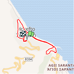
10.5 km | 14.5 km-effort
3h 45min
No
Trail Walking  - Grece Pelion : Tsagarada Damourachi Fakistra - Photo
Walking
Angie***

Walking

Difficult
, Thessaly and Central Greece, Regional Unit of Magnesia, Greece
9.4 km | 17.1 km-effort
3h 53min
Yes


Close
My subscriptions