![](/images/other/stat-length.png)
![Trail Walking Moux-en-Morvan - Marche Expérimentale Légion VIII Augusta - Anost - Saulieu - Photo](https://media.geolcdn.com/t/1900/400/ext.pjpeg?maxdim=2&url=https%3A%2F%2Fservices.sitytrail.com%2FGeolivesWS%2FDownloadMedia.ashx%3FTrailID%3D214881%26Media%3D15428_2.jpg)
Marche Expérimentale Légion VIII Augusta - Anost - Saulieu
tracegps
User
![Length](/images/other/stat-length.png)
![Max alt](https://static1.geolcdn.com/siteimages/upload/files/1508320355ic_sort_altitude_max_24dp.png)
![Uphill gradient](https://static1.geolcdn.com/siteimages/upload/files/1508320355ic_sort_den_pos_24dp.png)
![Km-Effort](/images/other/stat-length.png)
![Min alt](https://static1.geolcdn.com/siteimages/upload/files/1508320355ic_sort_altitude_min_24dp.png)
![Downhill gradient](https://static1.geolcdn.com/siteimages/upload/files/1508320355ic_sort_den_neg_24dp.png)
![Boucle](https://static1.geolcdn.com/siteimages/upload/files/16400158638029165_repeat_loop_refresh_sync_direction_icon.png)
![Walking](https://static1.geolcdn.com/sitytour/trail-icons/101.png)
5h00
Difficulty : Difficult
![Scan this QR Code to open this trail in the SityTrail application](https://capi.geolives.com/qq0zvz2zws4bq2lad0pu/sitytour/trails/214881/qr.png?size=200)
FREE GPS app for hiking
About
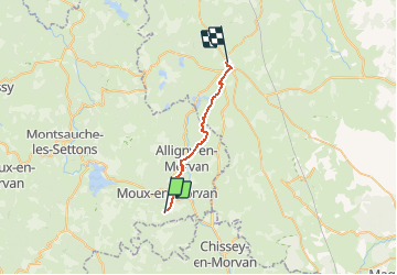
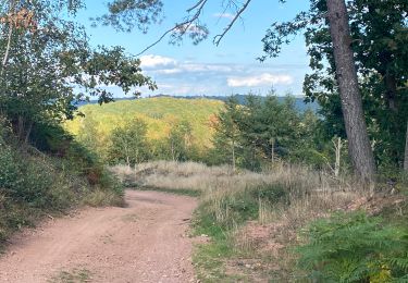
Trail Walking of 19 km to be discovered at Bourgogne-Franche-Comté, Nièvre, Moux-en-Morvan. This trail is proposed by tracegps.
Description
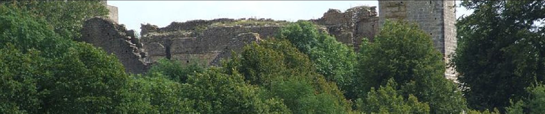
En 2010, l'association Légion VIII Augusta lançait un projet original : parcourir les 120 km qui séparent Bibracte d'Alésia, et ce, en essayant de reproduire les conditions de déplacement d'une patrouille de l'armée romaine. Expérimentant la résistance des équipements et les questions liées à l'hygiène et à l'approvisionnement en eau en 2010, ils ont été accompagnés en 2011 de deux mules. "Pierre Ecrite" est le nom d'un hameau de la commune d'Alligny-en-Morvan. Il est situé sur le tracé du chemin de Bibracte à Alésia, et doit son nom à une stèle gallo-romaine qui se dresse sous un tilleul du hameau et sur laquelle sont sculptés cinq personnages. D'origine gauloise ou gallo-romaine, elle n'a pas livré tous ses secrets : Cette pierre funéraire représente-elle une famille : Le père, la mère et à leurs pieds trois enfants, un riche couple et leurs employés ou bien une famille de bûcherons dont l'un d'eux est armé d'un coutre de fendeur ? A sa base peut-être quelques lettres grecques en usage chez les druides Gaulois. Selon l'archéologue J-G Bulliot : les cinq personnages représenteraient une famille de bûcherons. L'un de ces personnages tiendrait un coutre de fendeur alors qu'un autre fabriquerait une boule de bois sur un tour afin d'en tirer, en la partageant, deux écuelles de bois. Saulieu situé sur la Via Agrippa se dénommait à l’époque gallo-romaine Sidolocus ou Sidis Locus et profitait de sa situation privilégiée entre Aballo (Avallon) et Augustodonum (Autun).
Positioning
Comments
Trails nearby
![Trail Running Moux-en-Morvan - moux 2 trail et mix - Photo](https://media.geolcdn.com/t/375/260/ext.jpg?maxdim=2&url=https%3A%2F%2Fservices.sitytrail.com%2FGeolivesWS%2FDownloadMedia.ashx%3FTrailID%3D970060%26Media%3Dfix__20180520120201.jpg)
![Running Running](https://static1.geolcdn.com/sitytour/trail-icons/103.png)
Running
![](/images/other/stat-length.png)
![](https://static1.geolcdn.com/siteimages/upload/files/16400158638029165_repeat_loop_refresh_sync_direction_icon.png)
![Trail Walking Moux-en-Morvan - Manu-161008 - Morvan-LacSettons - Photo](https://media.geolcdn.com/t/375/260/ext.jpg?maxdim=2&url=https%3A%2F%2Fservices.sitytrail.com%2FGeolivesWS%2FDownloadMedia.ashx%3FTrailID%3D644928%26Media%3D1dcf9f96-3e9e-4659-bcc7-f9b68ec6230b.jpg)
![Walking Walking](https://static1.geolcdn.com/sitytour/trail-icons/101.png)
Walking
![](/images/other/stat-length.png)
![](https://static1.geolcdn.com/siteimages/upload/files/16400158638029165_repeat_loop_refresh_sync_direction_icon.png)
![Trail Nordic walking Moux-en-Morvan - Settons - Photo](https://media.geolcdn.com/t/375/260/0d360a6e-93ae-486b-b02d-465a63bc0d8b.jpg&format=jpg&maxdim=2)
![Nordic walking Nordic walking](https://static1.geolcdn.com/sitytour/trail-icons/102.png)
Nordic walking
![](/images/other/stat-length.png)
![](https://static1.geolcdn.com/siteimages/upload/files/16400158638029165_repeat_loop_refresh_sync_direction_icon.png)
![Trail Walking Alligny-en-Morvan - Jarnoy circuit des résistants - Photo](https://media.geolcdn.com/t/375/260/eb41c6ef-1740-43a5-9975-b863e5e5ad28.jpg&format=jpg&maxdim=2)
![Walking Walking](https://static1.geolcdn.com/sitytour/trail-icons/101.png)
Walking
![](/images/other/stat-length.png)
![](https://static1.geolcdn.com/siteimages/upload/files/16400158638029165_repeat_loop_refresh_sync_direction_icon.png)
![Trail Walking Alligny-en-Morvan - Jarnoy chemin du tortillard. - Photo](https://media.geolcdn.com/t/375/260/2fb438a4-48d3-49c8-a66f-74c8044f2072.jpg&format=jpg&maxdim=2)
![Walking Walking](https://static1.geolcdn.com/sitytour/trail-icons/101.png)
Walking
![](/images/other/stat-length.png)
![](https://static1.geolcdn.com/siteimages/upload/files/16400158638029165_repeat_loop_refresh_sync_direction_icon.png)
![Trail Walking Ménessaire - Ménessaire - Photo](https://media.geolcdn.com/t/375/260/ext.jpg?maxdim=2&url=https%3A%2F%2Fservices.sitytrail.com%2FGeolivesWS%2FDownloadMedia.ashx%3FTrailID%3D104687%26Media%3D8090_1.jpg)
![Walking Walking](https://static1.geolcdn.com/sitytour/trail-icons/101.png)
Walking
![](/images/other/stat-length.png)
![](https://static1.geolcdn.com/siteimages/upload/files/16400158638029165_repeat_loop_refresh_sync_direction_icon.png)
![Trail Road bike Moux-en-Morvan - Lac des Settons - Photo](https://media.geolcdn.com/t/375/260/d6a2ef37-6bb3-4a15-ae45-65d4860cd8d2.jpg&format=jpg&maxdim=2)
![Road bike Road bike](https://static1.geolcdn.com/sitytour/trail-icons/201.png)
Road bike
![](/images/other/stat-length.png)
![](https://static1.geolcdn.com/siteimages/upload/files/16400158638029165_repeat_loop_refresh_sync_direction_icon.png)
![Trail Walking Moux-en-Morvan - 29 - MOUX-EN-MORVAN - IGM - Photo](https://media.geolcdn.com/t/375/260/ext.jpg?maxdim=2&url=https%3A%2F%2Fstatic1.geolcdn.com%2Fsiteimages%2Fupload%2Ffiles%2F1553511878bg_sport_marche.png)
![Walking Walking](https://static1.geolcdn.com/sitytour/trail-icons/101.png)
Walking
![](/images/other/stat-length.png)
![](https://static1.geolcdn.com/siteimages/upload/files/16400158638029165_repeat_loop_refresh_sync_direction_icon.png)
![Trail Walking Moux-en-Morvan - Tour du Morvan pédestre - de Moux à Saint Brisson - Photo](https://media.geolcdn.com/t/375/260/ext.jpg?maxdim=2&url=https%3A%2F%2Fstatic1.geolcdn.com%2Fsiteimages%2Fupload%2Ffiles%2F1553511878bg_sport_marche.png)
![Walking Walking](https://static1.geolcdn.com/sitytour/trail-icons/101.png)
Walking
![](/images/other/stat-length.png)
![](https://static1.geolcdn.com/siteimages/upload/files/16400158638029165_repeat_loop_refresh_sync_direction_icon.png)