![](/images/other/stat-length.png)
![Trail Walking Thurins - Rando des 9 clochers 2013 - Thurins - Photo](https://media.geolcdn.com/t/1900/400/ext.pjpeg?maxdim=2&url=https%3A%2F%2Fservices.sitytrail.com%2FGeolivesWS%2FDownloadMedia.ashx%3FTrailID%3D214873%26Media%3D15374_1.jpg)
Rando des 9 clochers 2013 - Thurins
tracegps
User
![Length](/images/other/stat-length.png)
![Max alt](https://static1.geolcdn.com/siteimages/upload/files/1508320355ic_sort_altitude_max_24dp.png)
![Uphill gradient](https://static1.geolcdn.com/siteimages/upload/files/1508320355ic_sort_den_pos_24dp.png)
![Km-Effort](/images/other/stat-length.png)
![Min alt](https://static1.geolcdn.com/siteimages/upload/files/1508320355ic_sort_altitude_min_24dp.png)
![Downhill gradient](https://static1.geolcdn.com/siteimages/upload/files/1508320355ic_sort_den_neg_24dp.png)
![Boucle](https://static1.geolcdn.com/siteimages/upload/files/16400158638029165_repeat_loop_refresh_sync_direction_icon.png)
![Walking](https://static1.geolcdn.com/sitytour/trail-icons/101.png)
10h00
Difficulty : Difficult
![Scan this QR Code to open this trail in the SityTrail application](https://capi.geolives.com/qq0zvz2zws4bq2lad0pu/sitytour/trails/214873/qr.png?size=200)
FREE GPS app for hiking
About
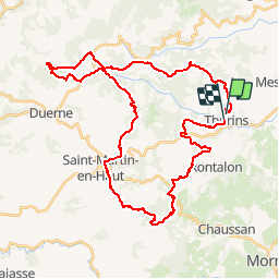
Trail Walking of 41 km to be discovered at Auvergne-Rhône-Alpes, Rhône, Thurins. This trail is proposed by tracegps.
Description
Le départ du 43 km se fait entre 7h et 8h. Le point culminant est le Signal de St André (934 m). Pas de difficultés particulières si ce n'est la distance. Habituellement, nous avons de 60 à 90 marcheurs sur ce circuit, qui mettent de 10h à 12 h pour le boucler. Le repas d'arrivée est servi jusqu'au dernier arrivant. Enfin, il est possible de couper 2 fois le circuit pour rejoindre la boucle du 33 km si vous avez une faiblesse ! (extrait Organisation)
Positioning
Comments
Trails nearby
![Trail Walking Messimy - De Messimy au belvédère du Piragoy en boucle - Photo](https://media.geolcdn.com/t/375/260/4f6a03fe-103d-4ea3-ac7c-d9a11a0a7724.jpg&format=jpg&maxdim=2)
![Walking Walking](https://static1.geolcdn.com/sitytour/trail-icons/101.png)
Walking
![](/images/other/stat-length.png)
![](https://static1.geolcdn.com/siteimages/upload/files/16400158638029165_repeat_loop_refresh_sync_direction_icon.png)
![Trail Walking Thurins - tour du bois du baron - Photo](https://media.geolcdn.com/t/375/260/ext.jpg?maxdim=2&url=https%3A%2F%2Fservices.sitytrail.com%2FGeolivesWS%2FDownloadMedia.ashx%3FTrailID%3D548394%26Media%3Dfix__20160403153341.jpg)
![Walking Walking](https://static1.geolcdn.com/sitytour/trail-icons/101.png)
Walking
![](/images/other/stat-length.png)
![](https://static1.geolcdn.com/siteimages/upload/files/16400158638029165_repeat_loop_refresh_sync_direction_icon.png)
![Trail Mountain bike Messimy - monté technique - Photo](https://media.geolcdn.com/t/375/260/ext.jpg?maxdim=2&url=https%3A%2F%2Fstatic1.geolcdn.com%2Fsiteimages%2Fupload%2Ffiles%2F1524743154velo.jpg)
![Mountain bike Mountain bike](https://static1.geolcdn.com/sitytour/trail-icons/202.png)
Mountain bike
![](/images/other/stat-length.png)
![](https://static1.geolcdn.com/siteimages/upload/files/16400158638029165_repeat_loop_refresh_sync_direction_icon.png)
![Trail Walking Yzeron - Yzeron - Les terres de Barmont - Photo](https://media.geolcdn.com/t/375/260/ext.jpg?maxdim=2&url=https%3A%2F%2Fstatic1.geolcdn.com%2Fsiteimages%2Fupload%2Ffiles%2F1553511878bg_sport_marche.png)
![Walking Walking](https://static1.geolcdn.com/sitytour/trail-icons/101.png)
Walking
![](/images/other/stat-length.png)
![](https://static1.geolcdn.com/siteimages/upload/files/16400158638029165_repeat_loop_refresh_sync_direction_icon.png)
![Trail Walking Thurins - thurins la chap. château neuf st Laurent de vaux - Photo](https://media.geolcdn.com/t/375/260/f3d6c053-06d8-4319-9ba3-960eec1a724b.jpg&format=jpg&maxdim=2)
![Walking Walking](https://static1.geolcdn.com/sitytour/trail-icons/101.png)
Walking
![](/images/other/stat-length.png)
![](https://static1.geolcdn.com/siteimages/upload/files/16400158638029165_repeat_loop_refresh_sync_direction_icon.png)
![Trail Walking Messimy - messimy. thurins. soucieux en jarrest - Photo](https://media.geolcdn.com/t/375/260/671b857f-de41-42c9-86c8-35db977a224d.jpg&format=jpg&maxdim=2)
![Walking Walking](https://static1.geolcdn.com/sitytour/trail-icons/101.png)
Walking
![](/images/other/stat-length.png)
![](https://static1.geolcdn.com/siteimages/upload/files/16400158638029165_repeat_loop_refresh_sync_direction_icon.png)
![Trail Walking Brindas - de brindas à soucieux en jarrest - Photo](https://media.geolcdn.com/t/375/260/0437dd9e-577f-4074-95ce-afdcae6f044f.jpg&format=jpg&maxdim=2)
![Walking Walking](https://static1.geolcdn.com/sitytour/trail-icons/101.png)
Walking
![](/images/other/stat-length.png)
![](https://static1.geolcdn.com/siteimages/upload/files/16400158638029165_repeat_loop_refresh_sync_direction_icon.png)
![Trail On foot Vaugneray - Circuit du Capauduc - Photo](https://media.geolcdn.com/t/375/260/2fad17de-e3ff-4154-a54e-2b877983e049.jpeg&format=jpg&maxdim=2)
![On foot On foot](https://static1.geolcdn.com/sitytour/trail-icons/100.png)
On foot
![](/images/other/stat-length.png)
![](https://static1.geolcdn.com/siteimages/upload/files/16400158638029165_repeat_loop_refresh_sync_direction_icon.png)
![Trail On foot Saint-Martin-en-Haut - Circuit des Sources du Garon - Photo](https://media.geolcdn.com/t/375/260/fe014065-bc06-4e54-b660-6900e183f331.jpeg&format=jpg&maxdim=2)
![On foot On foot](https://static1.geolcdn.com/sitytour/trail-icons/100.png)
On foot
![](/images/other/stat-length.png)
![](https://static1.geolcdn.com/siteimages/upload/files/16400158638029165_repeat_loop_refresh_sync_direction_icon.png)